

You are here
Avalanche Advisory for 2016-02-16 06:44:39
- EXPIRED ON February 17, 2016 @ 6:44 amPublished on February 16, 2016 @ 6:44 am
- Issued by Jon Dove - Shasta-Trinity National Forest
Bottom Line
LOW avalanche danger exists throughout the forecast area, all elevations and aspects. Loose wet snow instabilities such as roller balls, pinwheels, and loose wet avalanches are possible today on southerly facing aspects, slopes 37 degrees and steeper, during the warmest parts of the day. NORMAL CAUTION is advised.
Avalanche danger will increase for wind slabs and storm slabs tomorrow as a wet weather pattern returns to our area.


Avalanche Problem 1: Loose Wet
-
Character ?

-
Aspect/Elevation ?
-
Likelihood ?CertainVery LikelyLikelyPossible
 Unlikely
 -
Size ?HistoricVery LargeLargeSmall

Any loose wet snow instabilities will be limited to southerly facing aspects, elevations of 10,000 ft. and below, during the warmest parts of the day, today. They may take the form of roller balls, pinwheels, point-release sluff slides, or loose wet avalanches. These avalanches typically occur within the layer of wet snow on the surface of the snowpack, but may quickly gouge into deeper snowpack layers. They start at a point and entrain snow as they move down slope fanning out as they progress. They generally move slowly, but can contain enough snow to be a problem to backcountry travelers. Common areas to find these kinds of instabilities would be the SE aspect of Casaval Ridge that falls into Avalanche Gulch, the SE aspects of both Sun Bowl and Powder Bowl, and the southerly aspect of Right Peak at Castle Lake.
Forecast Discussion
We are on the verge of a shift back to a more active wet weather pattern, if only for just a few days. A vigorous set of strong systems is set to arrive on Wednesday, and pass over the region during the second half of the week. The first of these systems, however, is still well off shore meaning one more day of sunshine and some high clouds for today. "Spring like" conditions will persist, but will be tempered above treeline by moderate winds. A northwesterly wind direction will shift this afternoon toward a more southwesterly direction with the approaching front. Wind speeds at mid-mountain (10,000-11,000 ft.) will remain moderate for today at 25-30 mph, then increasing as Wednesday's storm passes overhead. Stormy weather will continue on Thursday and Friday with the three day water amounts totaling 2.04 inches. Snow levels will start out above 8,000 ft. as the first storm arrives early Wednesday, but will lower to around 5,000 ft. as the system passes. Snow levels will fall further Wednesday night, and again Thursday night, to around 3,500 ft. Get your powder skis waxed up!
THIS SEASON PRECIPITATION for MT SHASTA CITY: Since October 1st (the wet season), we have received 22.62 inches of water, normal is 25.93 inches, putting us at 87% of normal. For the month of February we've received 0.13 inches of water, normal is 3.66 inches, putting us at 3% of normal, and finally... for the year of 2016 we've received 13.13 inches of water, normal is 10.72 inches, putting us at 122% of normal .
Recent Observations
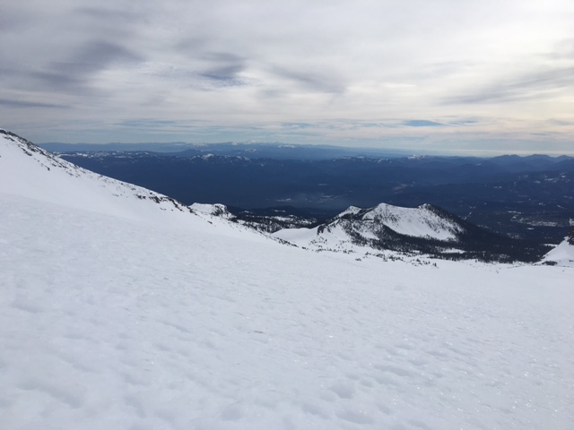
I took a look, yesterday, at the snow pack at higher elevations in an effort to find any possible wind slab formations from the light precipitation amounts received during Sunday's brief weather disturbance. At 10,000-11,000 ft. in Old Ski Bowl there was no sign of wind slab development. Wind speeds Sunday, and then again yesterday, were strong enough that any snow that had fallen was either completely sublimated, or simply blown away. The snow conditions present were indicative of the affect that the past 7+ days of warm and sunny weather have had on the snowpack. Snow layers have bonded nicely, and consolidated well. The snow surface was able to soften into corn snow conditions below 9,000 ft. The snow surface above this elevation was unable to soften due to gusty north/northwest winds. Firm and slightly variable snow surface conditions were found at 10,000 ft. with some spots being icy while others I could just kick in a shallow bootpack. Boot penetration measurements of 2-5 cm were recorded. Skinning uphill would have been difficult as the snow's surface had an icy glaze due to solar influenced melt/freeze at that elevation. Today, at 9,000 ft. and below any refreeze overnight will be superficial and quickly melt as the day warms up. Areas above 9,000 ft. will be wind scoured and icy, or breakable crust. Snow below treeline may get slightly sticky in the afternoon hours. Some decent corn snow conditions may be found in places like Sun Bowl, Powder Bowl, or the Castle Lake area.
For today, normal caution will continue to be our word of advice. For those who venture to mid-mountain elevations and higher expect firm, slightly variable snow, and breezy conditions. Southerly facing aspects may host loose wet snow instabilities in the form of roller balls, pinwheels, and point-release sluffs during the warmest parts of the day. While not much of a threat themselves, they could push you off your feet, over a cliff, into trees or rocks, into a terrain trap, etc. Use normal safe travel techniques. Avalanche danger will increase tomorrow for both storm and wind slabs. The firm and icy snow conditions will provide an ideally slick bed surface that may be hard for new snow to bond to.
Snow surface conditions in Old Ski Bowl 2/16/2016 at approximately 9,500 ft. -
________________________________________________________________________________________________________________________________________
LOCAL AREA ROAD, NORDIC and SNOWMOBILE PARK STATUS:
The Sand Flat cross country ski trails are in great shape and ready for your cross country skis or snow shoes. These are backcountry trails marked with blue diamonds on trees. Trails are not groomed. Snow shoers, please blaze a parallel trail to cross country skiers staying out of the skin track. These trails can be accessed via the Everett Memorial Highway. Thank you, and enjoy!
The Mt Shasta Nordic Center is open! These beautiful, groomed trails can be accessed via the Ski Park Highway. http://www.mtshastanordic.org
The Pilgrim Creek & Deer Mountain Snowmobile Parks are open! Trails are being groomed currently. Head to our "Education" tab on our website and find the snowmobile section for trail information, grooming status and other sledder resources!
The Castle Lake road is plowed to the lake. The Everett Memorial Highway is plowed to Bunny Flat.
The Five Red Flags of Avalanche Danger any time of year include: 1) Recent/current avalanche activity 2) Whumphing sounds or shooting cracks 3) Recent/current heavy snowfall 4) Strong winds transporting snow 5) Rapid warming or rain on snow.
Weather and Current Conditions
Weather Summary
Good Morning! In Mt Shasta City at 0500, we have a current temperature of 37 F, the same as yesterday at this time. Skies are clear with calm winds.
On Mt Shasta (South Side) in the last 24 hours...
Old Ski Bowl - 7,600 feet, the current temperature is 45 degrees F. Snow on the ground totals 103 inches with no new snow and 1 inch of settlement. Temperatures have ranged from 37 F to 51 F.
Grey Butte - 8,000 feet, the current temperature is 44 degrees F. Temperatures have ranged from 37 F to 46 F. Winds have been averaging 15-20 mph, northwest in direction with a max gust to 35 mph, NW.
Mt Eddy Range (West side of Interstate-5)...
Castle Lake - 5,600 feet, the current temperature is 44 degrees. Temperatures have ranged from 37 F to 56 F. Snow on the ground totals 58 inches with no new snow and little settlement.
Mt Eddy - 6,500 feet, the current temperature is 42 degrees F. Temperatures have ranged from 35 F to 48 F. Snow on the ground measures 73 inches with no new snow and 1 inch of settlement. Winds have averaged 3 mph, variable in direction with a max gust of 10 mph, south.
Always check the weather before you attempt to climb Mt Shasta. Further, monitor the weather as you climb. Becoming caught on the mountain in any type of weather can compromise life and limb. Be prepared.
| 0600 temperature: | 40 |
| Max. temperature in the last 24 hours: | 50 |
| Average wind direction during the last 24 hours: | Northwest |
| Average wind speed during the last 24 hours: | 15-20 mi/hr |
| Maximum wind gust in the last 24 hours: | 35 mi/hr |
| New snowfall in the last 24 hours: | 0 inches |
| Total snow depth: | 82 inches |
Two Day Mountain Weather Forecast
Produced in partnership with the Medford NWS
| For 7000 ft to 9000 ft | |||
|---|---|---|---|
|
Tuesday (4 a.m. to 10 p.m.) |
Tuesday Night (10 p.m. to 4 a.m.) |
Wednesday (4 a.m. to 10 p.m.) |
|
| Weather | Mostly sunny | Partly cloudy, then rain after 4 am | Rain showers before 10 am, then rain and snow showers. Then snow could be heavy at times. Windy |
| Temperature (°F) | 52 | 36 | 40 |
| Wind (mi/hr) | North then shifting to Southwest this afternoon 5-10 mph | South 10-15 mph | South 25-35 mph increasing to 30-45 mph in the afternoon |
| Precipitation SWE / Snowfall (in) | / 0 | / 0 | / 4-7 |
| For 9000 ft to 11000 ft | |||
| Tuesday | Tuesday Night | Wednesday | |
| Weather | Mostly sunny and windy | Partly cloudy then snow after 4 am. Windy | Snow before 10 am, then snow showers after 10 am. The snow could be heavy at times. Windy with wind chill values as low as -10 |
| Temperature (°F) | 34 | 34 | 23 |
| Wind (mi/hr) | West 25-30 mph with gusts to 55 mph | Southwest 0 | South 65-70 mph with higher gusts |
| Precipitation SWE / Snowfall (in) | / 0 | / 0-1 | / 9-13 |

