

You are here
Avalanche Advisory for 2016-02-17 06:54:42
- EXPIRED ON February 18, 2016 @ 6:54 amPublished on February 17, 2016 @ 6:54 am
- Issued by Nick Meyers - Shasta-Trinity National Forest
Bottom Line
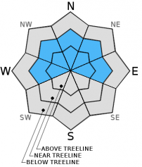
This morning, the avalanche danger is LOW for all elevations and aspects. This afternoon, the avalanche danger will increase as storm and wind slabs gain size and depth. MODERATE danger with pockets of CONSIDERABLE danger could be found near and above treeline late this afternoon. Wind loaded aspects E-NE-N-NW-W, near and above treeline should be most suspect.
Over the next 48 hours, up to 2 feet of new snow is possible with accompanied 40-50 mph south/southwest winds. Extra caution advised.


Avalanche Problem 1: Wind Slab
-
Character ?

-
Aspect/Elevation ?
-
Likelihood ?CertainVery LikelyLikelyPossible
 Unlikely
 -
Size ?HistoricVery LargeLargeSmall

Wind slab avalanche danger will increase today with new snow accumulation and wind loading. A winter storm is expected to bring up to 2 feet of new snow and high southerly winds over the next two days. Leeward slopes facing E-NE-N-NW-W will become rapidly wind loaded by new snow and wind transport. Existing snow surface conditions remains firm, melt/freeze snow. With the storm arriving warm and gradually becoming cooler, bonding of the new snow to the old snow may be good. That said, wind transport can load slopes 10x faster than falling snow... it could be simply a matter of too much snow too quickly, and that could tip the stress vs. strength scale. LOW wind slab avalanche danger this morning will rise to MODEARTE with pockets of CONSIDERABLE danger by late this afternoon.
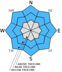
Avalanche Problem 2: Storm Slab
-
Character ?

-
Aspect/Elevation ?
-
Likelihood ?CertainVery LikelyLikelyPossible
Unlikely
-
Size ?HistoricVery LargeLargeSmall
Just like with wind slabs, storm slab danger will increase later today as storm snow builds up. Upwards of one inch of water today could bring up to a foot of new snow to elevations above 7,000 feet in the forecast area. Above treeline, storm slab formation will be limited due to high south/southwest winds. Near and below treeline, one can expect storm slabs to form and build in size as the storm progresses. Storm slabs will be most sensitive over the next 48 hours, specifically later tonight and tomorrow.
Forecast Discussion
A wet and windy few days is queing up just off the coast of California. Low pressure at 135W will move overhead and provide the area up to approximately 2 inches of rain by Thursday morning. Indeed it is quite balmy this morning. The good news... cold air is moving in and we will see temperatures fall throughout the day, and even further into the storm tomorrow. Thus, snow levels wil begin high, near 6,700 feet today, 4,500 feet tonight and to town by Thursday. Wind is notable with this system... above treeline, 700 mb winds indicate a steady flow of 40-50 mph wind with gusts higher. Winds will sustain for the next several days in the high country. By the end of the week, we could see upwards of 2 feet of fresh snow accompanied by high southerly wind. And just like that, we're back into Winter! The avalanche danger is certain to rise over the next few days with snow heavy at times and south/southwesterly wind.
THIS SEASON PRECIPITATION for MT SHASTA CITY: Since October 1st (the wet season), we have received 22.62 inches of water, normal is 26.21 inches, putting us at 86% of normal. For the month of February we've received 0.13 inches of water, normal is 3.94 inches, putting us at 3% of normal, and finally... for the year of 2016 we've received 13.13 inches of water, normal is 11.00 inches, putting us at 119% of normal .
Recent Observations
Currently, old existing melt/freeze snow awaits the new snow from the storm upon us. Rain this morning has already begun and a wet and windy system will bring a decent amount of new snow, wind and rain to the area. We have no existing concerns with the old snow. Avalanche concerns will lie within the new storm snow today. The avalanche danger will increase later this afternoon with the incoming storm. Wind and storm slabs will lead the avalanche problems for the next several days. As the storm arrives warm and then cools, we hope the warmer temps will help promote the new snow to "glue" onto existing snow. Near and above treeline will be the biggest area's of concern as cooler temperatures may not allow such good bonding as will mid to lower elevations.
Discussion from 12-16-16 (J. Dove):
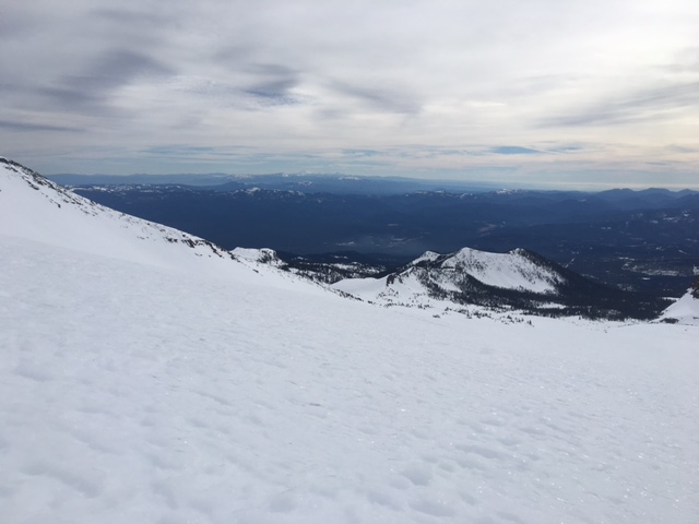
I took a look yesterday at the snow pack at higher elevations in an effort to find any possible wind slab formations from the light precipitation amounts received during Sunday's brief weather disturbance. At 10,000-11,000 ft. in Old Ski Bowl there was no sign of wind slab development. Wind speeds Sunday, and then again yesterday, were strong enough that any snow that had fallen was either completely sublimated, or simply blown away. The snow conditions present were indicative of the affect that the past 7+ days of warm and sunny weather have had on the snowpack. Snow layers have bonded nicely, and consolidated well. The snow surface was able to soften into corn snow conditions below 9,000 ft. The snow surface above this elevation was unable to soften due to gusty north/northwest winds. Firm and slightly variable snow surface conditions were found at 10,000 ft. with some spots being icy while others I could just kick in a shallow bootpack. Boot penetration measurements of 2-5 cm were recorded. Skinning uphill would have been difficult as the snow's surface had an icy glaze due to solar influenced melt/freeze at that elevation. Today, at 9,000 ft. and below any refreeze overnight will be superficial and quickly melt as the day warms up. Areas above 9,000 ft. will be wind scoured and icy, or breakable crust. Snow below treeline may get slightly sticky in the afternoon hours. Some decent corn snow conditions may be found in places like Sun Bowl, Powder Bowl, or the Castle Lake area.
Snow surface conditions in Old Ski Bowl 2/16/2016 at approximately 9,500 ft. -
________________________________________________________________________________________________________________________________________
LOCAL AREA ROAD, NORDIC and SNOWMOBILE PARK STATUS:
The Sand Flat cross country ski trails are in great shape and ready for your cross country skis or snow shoes. These are backcountry trails marked with blue diamonds on trees. Trails are not groomed. Snow shoers, please blaze a parallel trail to cross country skiers staying out of the skin track. These trails can be accessed via the Everett Memorial Highway. Thank you, and enjoy!
The Mt Shasta Nordic Center is open! These beautiful, groomed trails can be accessed via the Ski Park Highway. http://www.mtshastanordic.org
The Pilgrim Creek & Deer Mountain Snowmobile Parks are open! Trails are being groomed currently. Head to our "Education" tab on our website and find the snowmobile section for trail information, grooming status and other sledder resources!
The Castle Lake road is plowed to the lake. The Everett Memorial Highway is plowed to Bunny Flat.
The Five Red Flags of Avalanche Danger any time of year include: 1) Recent/current avalanche activity 2) Whumphing sounds or shooting cracks 3) Recent/current heavy snowfall 4) Strong winds transporting snow 5) Rapid warming or rain on snow.
Weather and Current Conditions
Weather Summary
Good Morning! In Mt Shasta City at 0500, we have a current temperature of 52 F, 15 degrees warmer than yesterday at this time. Skies are obscured with light winds.
On Mt Shasta (South Side) in the last 24 hours...
Old Ski Bowl - 7,600 feet, the current temperature is 35 degrees F. Snow on the ground totals 103 inches with no new snow and little settlement. Temperatures have ranged from 35 F to 50 F.
Grey Butte - 8,000 feet, the current temperature is 34 degrees F. Temperatures have ranged from 34 F to 48 F. Winds have been averaging 15-20 mph, northwest in direction with a max gust to 35 mph, NW until 2100....since then winds switched to southeast averaging 13 mph with gusts to 28 mph.
Mt Eddy Range (West side of Interstate-5)...
Castle Lake - 5,600 feet, the current temperature is 39 degrees. Temperatures have ranged from 39 F to 61 F. Snow on the ground totals 56 inches with no new snow and 1 inch settlement.
Mt Eddy - 6,500 feet, the current temperature is 37 degrees F. Temperatures have ranged from 36 F to 52 F. Snow on the ground measures 72 inches with no new snow and 1 inch of settlement. Winds have averaged 3 mph, variable in direction with a max gust of 16 mph, southwest.
Always check the weather before you attempt to climb Mt Shasta. Further, monitor the weather as you climb. Becoming caught on the mountain in any type of weather can compromise life and limb. Be prepared.
| 0600 temperature: | 37 |
| Max. temperature in the last 24 hours: | 54 |
| Average wind direction during the last 24 hours: | Northwest, switching to South |
| Average wind speed during the last 24 hours: | 15-20 mi/hr |
| Maximum wind gust in the last 24 hours: | 35 mi/hr |
| New snowfall in the last 24 hours: | 0 inches |
| Total snow depth: | 81 inches |
Two Day Mountain Weather Forecast
Produced in partnership with the Medford NWS
| For 7000 ft to 9000 ft | |||
|---|---|---|---|
|
Wednesday (4 a.m. to 10 p.m.) |
Wednesday Night (10 p.m. to 4 a.m.) |
Thursday (4 a.m. to 10 p.m.) |
|
| Weather | Rain showers likely before 10am, then snow showers. The snow could be heavy at times. Temperature falling to around 34 by 5pm. Windy | Snow showers. The snow could be heavy at times. Low around 27. Windy | Snow showers. High near 30. Breezy |
| Temperature (°F) | 39 and falling | 27 | 30 |
| Wind (mi/hr) | South 15-25 mph | South 20-30 mph | South 15-25 mph |
| Precipitation SWE / Snowfall (in) | / 3-7 | / 5-9 | / 3-7 |
| For 9000 ft to 11000 ft | |||
| Wednesday | Wednesday Night | Thursday | |
| Weather | Snow showers, mainly after 10am. The snow could be heavy at times. Temperature falling to around 18 by 5pm. Wind chill values as low as -9. Windy | Snow showers. The snow could be heavy at times. Low around 10. Wind chill values as low as -19. Windy | Snow showers. High near 13. Wind chill values as low as -18. Windy |
| Temperature (°F) | 22 and falling | 10 | 13 |
| Wind (mi/hr) | Southwest 30-40 mph with gusts to 50 mph | Southwest 6-10 | Southwest 30-40 mph |
| Precipitation SWE / Snowfall (in) | / 6-10 | / 8-12 | / 6-10 |

