

You are here
Avalanche Advisory for 2016-02-18 06:54:08
- EXPIRED ON February 19, 2016 @ 6:54 amPublished on February 18, 2016 @ 6:54 am
- Issued by Nick Meyers - Shasta-Trinity National Forest
Bottom Line
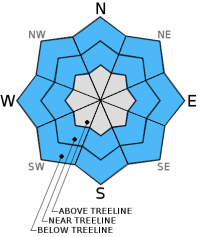
Today, below treeline on all aspects, the avalanche danger is MODERATE.
Near and above treeline, CONSIDERABLE avalanche danger will prevail. Isoloated pockets of HIGH danger may be found near and above treeline on W-NW-N-NE-E aspects due to rapid accumulation of wind transported snow.
Human triggered avalanches are likely today and natural avalanches possible. Avoid open and/or wind loaded slopes steeper than 30 degrees and pay attention to the terrain above you.


Avalanche Problem 1: Wind Slab
-
Character ?

-
Aspect/Elevation ?

-
Likelihood ?CertainVery LikelyLikelyPossible
 Unlikely
 -
Size ?HistoricVery LargeLargeSmall

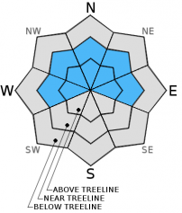
We will see a repeat of the storm that has occurred already over the next 48 hours. Southwest winds continue to blow and wind slabs will only increase in size and depth today. Slopes facing W-NW-N-NE-E will be the most heavily wind loaded. Slabs several feet thick are possible and could be very touchy. Slopes steeper than 35 degrees will be the most sensitive. Existing snow surface conditions remains firm, melt/freeze snow.
The unknown for us is how well the new snow bonded to the old snow. As one gains elevation today, red flags may begin to present themselves in the form of shooting cracks, whumfing, or even recent evidence of slides. We certainly are getting rapid snow accumulation with wind and that's a red flag in and of itself. Below treeline areas are not much of a concern. Steep convexities in the trees should be the biggest watch out for below treeline. Near and above treeline...that's where you'll need to be very careful and proceed cautiously... we advise only experienced backcountry travelers in the alpine today. Conduct stability tests and look for that potentially weak interface between new/old snow. Other weak layers or density changes may also be found within the new storm snow.
Avalanche Problem 2: Storm Slab
-
Character ?

-
Aspect/Elevation ?
-
Likelihood ?CertainVery LikelyLikelyPossible
Unlikely
-
Size ?HistoricVery LargeLargeSmall
Storm slabs got a slow start with this storm as snow below and near treeline did not begin to pile up until mid afternoon yesterday. Above treeline, winds have likely kept storm slab development at bay. Below and near treeline, slabs are buidlling in depth and will continue to do so. I'd expect dangerous storm slabs to begin popping up mid day today and increase in danger later this afternoon and tomorrow. Slopes steeper than 35 degrees should be most suspect for storm slab instabilities.
Avalanche Problem 3: Cornice
-
Character ?

-
Aspect/Elevation ?
-
Likelihood ?CertainVery LikelyLikelyPossible
Unlikely
-
Size ?HistoricVery LargeLargeSmall
Cornice formation along ridgelines will take place on leeward W-NW-N-NE-E facing aspects. Cornices can become very large, especially with heavy, wet snow. If triggered, hopefully you don't go with it, OR... hopefully it does not trigger a wind or storm slab below. Stay well away from ridgelines and be sure your up or down track is on terra firma! Cornices will build as the storm progresses. Common corniced areas are in the Castle Lake zone, Green Butte Ridge and Casaval Ridge.
Forecast Discussion
There is nothing like a little winter lightening and thunder storm to spice things up! It has been exciting having the electrical action yesterday, except when it knocks out all your weather stations. This wet-n-wild February storm is not done with us yet... another 1.55 inches of water is forecast to fall by the end of the work week. Temperatures have cooled also and will stay that way, so we should see the snow level stick to between 3,000 and 4,000 feet. All signs point towards continued snow in the forecast area with storm totals by Friday of 1 to 2 feet of new snow, perhaps more in wind loaded areas. Southwesterly winds will also continue to howl... while we don't have the Gray Butte station up, weather models suggest 40-50 mph winds at the 10,000 foot level. The jist: It's going to remain stormy for the rest of the week with ample new snow, high winds and potentially dangerous avalanche conditions. The weekend looks warmer slightly and drier...more on that later. Be careful out there today.
THIS SEASON PRECIPITATION for MT SHASTA CITY: Since October 1st (the wet season), we have received 24.19 inches of water, normal is 26.49 inches, putting us at 91% of normal. For the month of February we've received 1.70 inches of water, normal is 4.22 inches, putting us at 40% of normal, and finally... for the year of 2016 we've received 14.70 inches of water, normal is 11.28 inches, putting us at 130% of normal .
Recent Observations
Unfortunately, we have lost communications with all of our weather stations due to the lightening activity yesterday. The Gray Butte station commuincates with all the other stations...so if Gray Butte goes, they all go. Thus, we are making some educated guesses today and can make some reasonable assumptions based on the information that we do have. Sand Flat station, still up, recorded 5 inches of new snow over the past 24 hours. Temperatures at Sand Flat (6,750 feet) and Peterson Flat (7,150 feet) stations did not drop below freezing until about 1400 yesterday. The snow level hovered around 7,000 to 8,000 feet and perhaps even a bit higher early on in the storm. It wasn't until mid-afternoon that temps began to fall and the snow level dropped. Peterson Flat, over on the west side, received 10 inches of new snow. It also recorded snow accumulation beginning at 1400 hours. Mt. Shasta City recorded 1.69 inches of water. Southwesterly winds have been incessant.
The current situation out there is uncomplicated: rapid loading of new storm snow on top of old, melt/freeze snow and crusts. Except for above treeline areas, significant snow accumulation yesterday did not begin until mid-afternoon. The unknown at this point is how well the new snow has bonded to the old snow... and this is going to depend on elevation. The lower the elevation, likely the better the bonding. At higher, colder elevations, bonding may not be quite as good. Wet snow sticks well to old snow. Dryer, colder snow does not stick as well to old snow. My best guess is that areas above 9,000 feet could be quite touchy today. Add very windy southwesterlies into the mix and things could be very touchy! Wind loaded areas near and above treeline are certain and small to large wind slabs are most definintely possible, as well as small to large storm slabs. So, you guessed it... wind and storm slabs will lead the avalanche problems today. What we have already seen with this storm will essentially happen again over the next two days. Another 1.55 inches of water is forecast to fall by the end of the work week with continued southwest winds and snow levels hovering around 3-4,000 feet. Wind transported and storm snow will rapidly accumulate on our old melt/freeze snow surface and the chances of triggering an avalanche today are good.
________________________________________________________________________________________________________________________________________
LOCAL AREA ROAD, NORDIC and SNOWMOBILE PARK STATUS:
The Sand Flat cross country ski trails are in great shape and ready for your cross country skis or snow shoes. These are backcountry trails marked with blue diamonds on trees. Trails are not groomed. Snow shoers, please blaze a parallel trail to cross country skiers staying out of the skin track. These trails can be accessed via the Everett Memorial Highway. Thank you, and enjoy!
The Mt Shasta Nordic Center is open! These beautiful, groomed trails can be accessed via the Ski Park Highway. http://www.mtshastanordic.org
The Pilgrim Creek & Deer Mountain Snowmobile Parks are open! Trails are being groomed currently. Head to our "Education" tab on our website and find the snowmobile section for trail information, grooming status and other sledder resources!
The Castle Lake road is plowed to the lake. The Everett Memorial Highway is plowed to Bunny Flat.
The Five Red Flags of Avalanche Danger any time of year include: 1) Recent/current avalanche activity 2) Whumphing sounds or shooting cracks 3) Recent/current heavy snowfall 4) Strong winds transporting snow 5) Rapid warming or rain on snow.
Weather and Current Conditions
Weather Summary
Good Morning! In Mt Shasta City at 0500, we have a current temperature of 34 F, 18 degrees cooler than yesterday at this time. Some lingering light snow is falling with a skiff of fresh on the ground.
PLEASE NOTE: The weather station information below is from February 17th, 2016. During yesterday's lightening activity, we lost all communications with our weather stations. We suspect the Gray Butte station was compromised. We are working with US Forest Service tech's to get the stations back up as soon as possible. Thank you for understanding.
On Mt Shasta (South Side) in the last 24 hours...
Old Ski Bowl - 7,600 feet, the current temperature is 35 degrees F. Snow on the ground totals 103 inches with no new snow and little settlement. Temperatures have ranged from 35 F to 50 F.
Grey Butte - 8,000 feet, the current temperature is 34 degrees F. Temperatures have ranged from 34 F to 48 F. Winds have been averaging 15-20 mph, northwest in direction with a max gust to 35 mph, NW until 2100....since then winds switched to southeast averaging 13 mph with gusts to 28 mph.
Mt Eddy Range (West side of Interstate-5)...
Castle Lake - 5,600 feet, the current temperature is 39 degrees. Temperatures have ranged from 39 F to 61 F. Snow on the ground totals 56 inches with no new snow and 1 inch settlement.
Mt Eddy - 6,500 feet, the current temperature is 37 degrees F. Temperatures have ranged from 36 F to 52 F. Snow on the ground measures 72 inches with no new snow and 1 inch of settlement. Winds have averaged 3 mph, variable in direction with a max gust of 16 mph, southwest.
Always check the weather before you attempt to climb Mt Shasta. Further, monitor the weather as you climb. Becoming caught on the mountain in any type of weather can compromise life and limb. Be prepared.
| 0600 temperature: | 24 |
| Max. temperature in the last 24 hours: | 36 |
| Average wind direction during the last 24 hours: | Southerly |
| Average wind speed during the last 24 hours: | 10-20 mi/hr |
| Maximum wind gust in the last 24 hours: | n/a mi/hr |
| New snowfall in the last 24 hours: | 5-7 inches |
| Total snow depth: | 86 inches |
Two Day Mountain Weather Forecast
Produced in partnership with the Medford NWS
| For 7000 ft to 9000 ft | |||
|---|---|---|---|
|
Thursday (4 a.m. to 10 p.m.) |
Thursday Night (10 p.m. to 4 a.m.) |
Friday (4 a.m. to 10 p.m.) |
|
| Weather | Snow showers, chance of precip 100%, windy | Snow showers, chance of precip 90%, windy | Snow showers, chance of precip 100%, windy |
| Temperature (°F) | 31 | 25 | 29 |
| Wind (mi/hr) | South 15-25 mph | South 15-25 mph | Southwest 15-25 mph |
| Precipitation SWE / Snowfall (in) | / 4-8 | / 4-8 | / 10-16 |
| For 9000 ft to 11000 ft | |||
| Thursday | Thursday Night | Friday | |
| Weather | Snow showers, windy | Snow showers, windy | Snow showers, windy |
| Temperature (°F) | 14 | 13 | 13 |
| Wind (mi/hr) | Southwest/West 45-55 mph | Southwest 6-10 | Southwest 45-55 mph |
| Precipitation SWE / Snowfall (in) | / 6-10 | / 4-8 | / 12-18 |

