

You are here
Avalanche Advisory for 2016-02-19 07:01:28
- EXPIRED ON February 20, 2016 @ 7:01 amPublished on February 19, 2016 @ 7:01 am
- Issued by Nick Meyers - Shasta-Trinity National Forest
Bottom Line
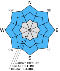
CONSIDERABLE avalanche danger exists near and above treeline on slopes steeper than 37 degrees, W-NW-N-NE-E facing due to wind and storm slabs. Elsewhere, overall MODERATE avalanche danger will prevail. Be able to identify where wind and storm slabs exist and avoid them if on steep slopes. Solid snowpack evaluation with cautious route-finding and sound decision making will be important today near and above treeline.


Avalanche Problem 1: Wind Slab
-
Character ?

-
Aspect/Elevation ?

-
Likelihood ?CertainVery LikelyLikelyPossible
 Unlikely
 -
Size ?HistoricVery LargeLargeSmall

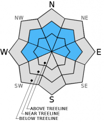
Continued strong southwesterly winds and significant amounts of new storm snow at mid to upper elevations over the past two days mean that wind slabs have formed on open and some protected slopes at all elevations. The largest and most sensitive wind slabs will exist on steep slopes, 37 degrees or greater, near and above treeline on W-NW-N-NE-E aspects. Wind slabs could also exist in more sheltered areas due to high wind speeds. These wind slabs will continue to grow in size and extent today. Natural wind slab release remains possible today. Human triggered wind slabs are certainly possible and could involve enough snow to bury people. The wind slabs will most likely fail on weaknesses withing the new snow, but some could break on the old snow surface above treeline. Use clues like cornices above a slope, blowing snow, wind drifted snow, ripples in the snow surface and other wind created textures to help identify where wind slabs may exist. Using observations like these to find wind slabs and then avoiding them is a good idea today!
Avalanche Problem 2: Storm Slab
-
Character ?

-
Aspect/Elevation ?
-
Likelihood ?CertainVery LikelyLikelyPossible
Unlikely
-
Size ?HistoricVery LargeLargeSmall
The storms in progress now arrived warm and progressively got colder. Subtle changes in temperature accompanied by rapid snow accumulation could have created some weaknesses within the new storm snow. Graupel layers or small density changes are common. Failures on these weaknesses could come in the form of small loose dry point releases. They could also allow human triggered storm slabs on open slopes, steeper than 37 degrees, near and below treeline where good storm slab characteristics exist.
Avalanche Problem 3: Cornice
-
Character ?

-
Aspect/Elevation ?
-
Likelihood ?CertainVery LikelyLikelyPossible
Unlikely
-
Size ?HistoricVery LargeLargeSmall
Cornice formation along ridgelines will take place on leeward W-NW-N-NE-E facing aspects. Cornices can become very large, especially with heavy, wet snow. If triggered, hopefully you don't go with it, OR... hopefully it does not trigger a wind or storm slab below. Stay well away from ridgelines and be sure your up or down track is on terra firma! Cornices will build as the storm progresses. Common corniced areas are in the Castle Lake zone, Green Butte Ridge and Casaval Ridge.
Forecast Discussion
A second blast of wintery weather is beginning to move over the Shasta area this morning. Back to back storm systems, this second storm is bringing a potent mix of wind and rain and snow on this fine Friday. The highest precip rates will occur over the first half of the day today and dwindle by nightfall. Tomorrow is forecast to be partly sunny. Today we will see continued southwest flow with up to .75 inches of water during daylight hours and snow levels at about 4,000 feet or slightly above. It will be very windy on the mountain and in the high country today. Winds will however decrease through tomorrow. Slightly warmer and drier weather will ensure this weekend and the next best chance at another storm is on Tuesday, though confidence is low.
THIS SEASON PRECIPITATION for MT SHASTA CITY: Since October 1st (the wet season), we have received 24.54 inches of water, normal is 26.77 inches, putting us at 91% of normal. For the month of February we've received 2.05 inches of water, normal is 4.50 inches, putting us at 45% of normal, and finally... for the year of 2016 we've received 15.05 inches of water, normal is 11.56 inches, putting us at 130% of normal .
Recent Observations
One of the first things I noticed on my way up the Everitt Memorial Highway yesterday was all the tree litter on the snow surface and roadway. It doesn't take a snow nerd to put two and two together here... very windy southwest flow has prevailed during the course of these two, back to back winter storms this week. Travels yesterday took me to the Bunny Flat area and up to the top of Gray Butte. While I was not able to get the weather stations back up (continuing to work on this), I was able to make some good snow observations.
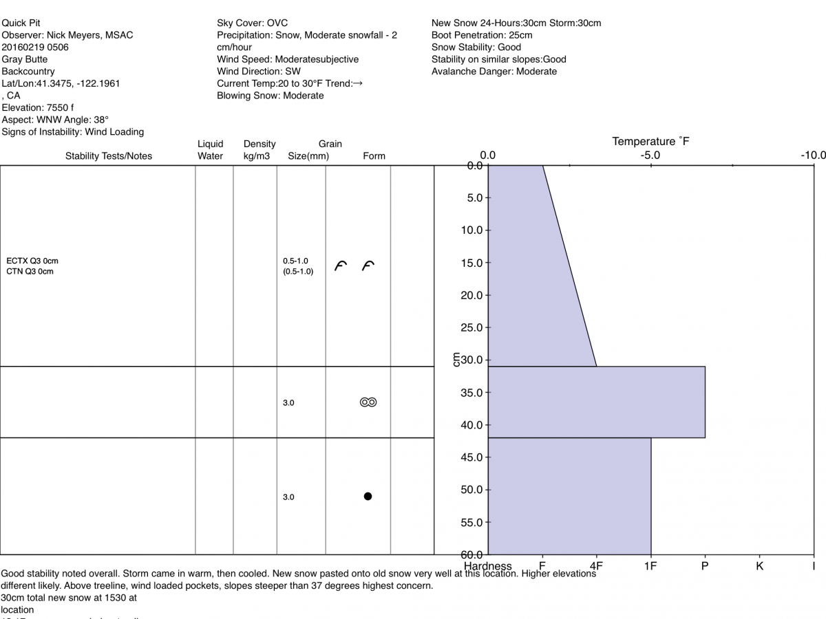
Below treeline, from about 6,500 feet to just below treeline (7,400 feet) I observed about 5-7 inches of new snow on top of the old melt/partially frozen snow. Instabilities were slim to none in below treeline areas. Near and above treeline, the snowpack was highly variable from wind scoured ridgelines to 1 to 2 foot wind slabs to 8-12 inch storm slabs. All that said, the stability was pretty darn good. I was unable to initiate any decisive fractures in any stability tests. Shear quality amongst test was very poor. Small test slopes would not fracture or propagate. A snow pit revealed very good bonding of the new snow with the old snow at the pit location. While we have had high winds and rapid accumulation of snow at times (both storm snow and wind transported), the storm(s) arrived warm and slowly cooled allowing for the new snow to "paste" onto the old very well. The classic "right side up" snowpack existed at my pit location and for all aspects below 8,000 feet.
The forecast area will get another round of snow and wind today. My biggest concern lies for steep slopes, at and above treeline, in areas where medium to large wind pillows/slabs have formed. As one gains elevation and the temperature cools, the old snow/new snow bonding may not be as good as near/below treeline areas. For those at and above treeline areas mentioned, extreme terrain, cross loaded couloirs, rock outcroppings and funky terrain where wind pillows have built up and perhaps hang precariously on a steeper slope...these are the areas of most concern. Poor visibility will likely limit most above treeline travel today.
________________________________________________________________________________________________________________________________________
LOCAL AREA ROAD, NORDIC and SNOWMOBILE PARK STATUS:
The Sand Flat cross country ski trails are in great shape and ready for your cross country skis or snow shoes. These are backcountry trails marked with blue diamonds on trees. Trails are not groomed. Snow shoers, please blaze a parallel trail to cross country skiers staying out of the skin track. These trails can be accessed via the Everett Memorial Highway. Thank you, and enjoy!
The Mt Shasta Nordic Center is open! These beautiful, groomed trails can be accessed via the Ski Park Highway. http://www.mtshastanordic.org
The Pilgrim Creek & Deer Mountain Snowmobile Parks are open! Trails are being groomed currently. Head to our "Education" tab on our website and find the snowmobile section for trail information, grooming status and other sledder resources!
The Castle Lake road is plowed to the lake. The Everett Memorial Highway is plowed to Bunny Flat.
The Five Red Flags of Avalanche Danger any time of year include: 1) Recent/current avalanche activity 2) Whumphing sounds or shooting cracks 3) Recent/current heavy snowfall 4) Strong winds transporting snow 5) Rapid warming or rain on snow.
Weather and Current Conditions
Weather Summary
Good Morning! In Mt Shasta City at 0500, we have a current temperature of 38 F, 4 degrees warmer than yesterday at this time. Light to moderate rain is falling with breezy conditions.
PLEASE NOTE: During the February 17th lightening activity, we lost all communications with our weather stations. Power has been compromised to the building on Gray Butte , where the base station exists for all our weather stations. We are working with Pacific Power and the US Forest Service tech's to get power restored as soon as possible. Thank you for understanding.
Below are a few nearby weather stations that are still up:
Sand Flat: 6,750 ft - the current temperature is 27 degrees F. Snow on the ground measures 90 inches with 4 inches new snow in the last 24 hours. Temperatures have ranged from 24 F to 30 F.
Peterson Flat: 7,150 ft - the current temperature is 27 F. Snow on the ground measures 69 inches with 5 inches new snow in the last 24 hours. Temperatures have ranged from 23 F to 30 F.
-------------------------------------------------------------------------------------------------------------------------------------------------------------------
On Mt Shasta (South Side) in the last 24 hours...
Old Ski Bowl - 7,600 feet, the current temperature is XX degrees F. Snow on the ground totals XXX inches with XX new snow and XX settlement. Temperatures have ranged from XX F to XX F.
Grey Butte - 8,000 feet, the current temperature is XX degrees F. Temperatures have ranged from XX F to XX F. Winds have been averaging XX mph, XX in direction with a max gust to XX out of the XX
Mt Eddy Range (West side of Interstate-5)...
Castle Lake - 5,600 feet, the current temperature is XX degrees. Temperatures have ranged from XX F to XX F. Snow on the ground totals XX inches with XX new snow and X inch settlement.
Mt Eddy - 6,500 feet, the current temperature is XX degrees F. Temperatures have ranged from XX F to XX F. Snow on the ground measures XX inches with XX new snow and X inch of settlement. Winds have averaged X mph, XX in direction with a max gust of XX mph, out of the XX.
Always check the weather before you attempt to climb Mt Shasta. Further, monitor the weather as you climb. Becoming caught on the mountain in any type of weather can compromise life and limb. Be prepared.
| 0600 temperature: | 26 |
| Max. temperature in the last 24 hours: | 30 |
| Average wind direction during the last 24 hours: | Southerly |
| Average wind speed during the last 24 hours: | 20-30 mph mi/hr |
| Maximum wind gust in the last 24 hours: | n/a mi/hr |
| New snowfall in the last 24 hours: | 4-6 inches |
| Total snow depth: | 90 inches |
Two Day Mountain Weather Forecast
Produced in partnership with the Medford NWS
| For 7000 ft to 9000 ft | |||
|---|---|---|---|
|
Friday (4 a.m. to 10 p.m.) |
Friday Night (10 p.m. to 4 a.m.) |
Saturday (4 a.m. to 10 p.m.) |
|
| Weather | Snow before 1pm, then snow showers, mainly after 1pm. The snow could be heavy at times. WIndy. | Snow showers likely, mainly before 10pm. Mostly cloudy | Partly sunny |
| Temperature (°F) | 27 | 16 | 36 |
| Wind (mi/hr) | Southwest 25-35 mph, decreasing | Southwest 10-15 mph, drecreasing | Southeast 5-10 mph |
| Precipitation SWE / Snowfall (in) | / 9-13 | / 0-1 | / 0 |
| For 9000 ft to 11000 ft | |||
| Friday | Friday Night | Saturday | |
| Weather | Snow before 1pm, then snow showers, mainly after 1pm. The snow could be heavy at times. Temperature falling to around 15 by 7am. Wind chill values as low as -15 | Snow showers likely, mainly before 10pm. Mostly cloudy. Wind chill values as low as -14. | Partly sunny, windy |
| Temperature (°F) | 15 | 15 | 21 |
| Wind (mi/hr) | Southwest/West 45-55 mph, decreasing | Southwest 11-17 | Southwest 10-20 mph |
| Precipitation SWE / Snowfall (in) | / 11-17 | / 0-1 | / 0 |

