

You are here
Avalanche Advisory for 2016-02-20 07:01:41
- EXPIRED ON February 21, 2016 @ 7:01 amPublished on February 20, 2016 @ 7:01 am
- Issued by Jon Dove - Shasta-Trinity National Forest
Bottom Line
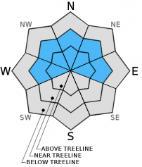
CONSIDERABLE avalanche danger for wind slabs exists above and near treeline. Slopes 37 degrees and steeper, leeward facing W-NW-N-NE-E-SE aspects will be most suspect. Overall, MODERATE avalanche danger exists all other locations. Human trigger of wind slabs is possible. Identify where wind and storm slabs may be. Avoid them, and possible runout zones. Roller balls and pinwheels may form, southerly aspects afternoon hours. Careful snowpack evaluation, cautious route-finding, and conservative decision making will be essential today.


Avalanche Problem 1: Wind Slab
-
Character ?

-
Aspect/Elevation ?
-
Likelihood ?CertainVery LikelyLikelyPossible
 Unlikely
 -
Size ?HistoricVery LargeLargeSmall

Strong southwesterly winds and significant amounts of new storm snow at mid to upper elevations over the past two days have developed wind slabs on open, and some protected slopes near and above treeline. The largest and most sensitive wind slabs will exist on slopes 37 degrees or steeper, on W-NW-N-NE-E aspects. Wind slabs could also exist in more sheltered areas due to the high wind speeds. These wind slabs will be most sensitive during the warmest parts of the day, especially on more southerly facing aspects. Natural wind slab release remains possible today. Human triggered wind slabs are certainly possible, and could involve enough snow to bury a person. The wind slabs will most likely fail at the density change identified approximately 48 cm deep, but some could break on the old snow surface above treeline. Use clues like cornices above a slope, blowing snow, wind drifted snow, ripples in the snow surface and other wind created textures to help identify where wind slabs may exist. Using observations like these to find wind slabs and then avoiding them is a good idea today!
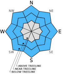
Avalanche Problem 2: Storm Slab
-
Character ?

-
Aspect/Elevation ?
-
Likelihood ?CertainVery LikelyLikelyPossible
Unlikely
-
Size ?HistoricVery LargeLargeSmall
Storm slabs that formed near and below treeline will settle today with an increase in temperature and plenty of sun exposure, especially on southerly facing aspects.The increase in temperature and solar gain today could create weakness within the new storm snow where small density changes exist. Failures on these weaknesses could come in the form of small loose dry point releases on shaded, northerly facing aspects. They could also allow human triggered storm slabs on open slopes, steeper than 37 degrees, near and below treeline where good storm slab characteristics exist. Loose wet instabilities in the form of roller balls or pinwheels may develop on southerly facing aspects in the warm afternoon hours.
Avalanche Problem 3: Cornice
-
Character ?

-
Aspect/Elevation ?

-
Likelihood ?CertainVery LikelyLikelyPossible
Unlikely
-
Size ?HistoricVery LargeLargeSmall
Cornice formation along ridgelines will take place on leeward W-NW-N-NE-E facing aspects. Cornices can become very large, especially with heavy, wet snow. If triggered, hopefully you don't go with it, OR... hopefully it does not trigger a wind or storm slab below. Stay well away from ridgelines and be sure your up or down track is on terra firma! Cornices will build as the storm progresses. Common corniced areas are in the Castle Lake zone, Green Butte Ridge and Casaval Ridge.
Forecast Discussion
As quickly as winter returned to our area, it makes it's exit stage right. According to NOAA meteorologists "The next several days will mark a battle of the seasons," as an a upper level ridge of high pressure builds over the region. The "battle" will be between this high pressure ridge and multiple attempts of weak, cold and wet systems to overcome the warm and dry ridge. The first front will make its attempt Sunday evening, but models show measurements of zero for any accompanied water amounts. The next front will approach late Thursday, but it too will be weak and will likely fail against the ridge. Models indicate that nothing will have the energy to force it's way past the high pressure over the coming week leaving relatively warm and dry conditions leading up to next weekend. Winds will be light to moderate today, increasing on Sunday as the cold front makes it's challenge. Temperatures will steadily increase through Tuesday with plenty of sunshine on tap.
THIS SEASON PRECIPITATION for MT SHASTA CITY: Since October 1st (the wet season), we have received 25.36 inches of water, normal is 27.05 inches, putting us at 93% of normal. For the month of February we've received 2.87 inches of water, normal is 4.78 inches, putting us at 60% of normal, and finally... for the year of 2016 we've received 15.87 inches of water, normal is 11.84 inches, putting us at 134% of normal .
Recent Observations
Yesterday brought the second round of wet weather of back to back storm systems bringing another 5+ inches of snow to the forecast area. This second system stayed cold maintaining the "right side up" layering structure of the new snow on top of old snow. As noted in yesterday's advisory the current bout of wet storms came in on Wednesday warm and wet with snow levels around 7,000 feet. The warmer temperatures and high water content of the snow enabled the crystals to more readily start to bond with the old snow surface near and below treeline. That is not to say that there is no chance of instabilities within the layers of new snow, especially in wind loaded areas near and above treeline where wind slabs have formed. In fact, sensitivities may still exist, and may be stressed by an increase in temperature and sun exposure today. As the day warms up and the snowpack settles added water weight may be just the thing to tip the stress vs. strength scale of wind slabs and lingering storm slabs.
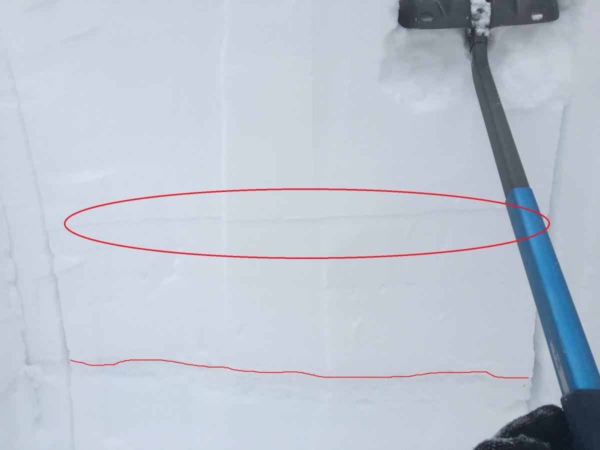
A ski tour up Green Butte Ridge revealed supportable powder snow, 9-13 inches deep, sitting on top of the old snow surface. A snow study pit was dug on the WNW aspect of the ridge above Avalanche Gulch at an elevation of approximately 8,000 feet on a slope of 34 degrees. The new snow, with an obvious density change 48 cm deep, sat on top of a thick melt-freeze crust. There were no indications of weakness at the interface of the old and new snow. Two extended column tests, however, did expose potential weakness at the density change noted at 48 cm. Both test required a moderate to strong amount of effort to initiate a fracture. The first test did not show any propagation, while the second test (photo below) did. This leads to some uncertainty as to wind slab sensitivity to trigger.
For today, the biggest concern for areas where one may potentially trigger a wind slab will be near and above treeline, on slopes 37 degrees and steeper, in the typical starting zones just below ridge tops, the tops of chutes or couloirs, and around rock outcroppings on leeward NW-N-NE-E-SE aspects. The sunny skies and good visibility will draw folks to above treeline locations today where wind slabs exist. As one gains elevation and the temperature cools, the old snow/new snow bonding may not be as good as near/below treeline areas. Caution should be taken when choosing one's route of travel, and areas where wind slabs/pillows may have formed should be identified and avoided.
Pit Profile from WNW aspect of Green Butte Ridge on 2-19-2016:
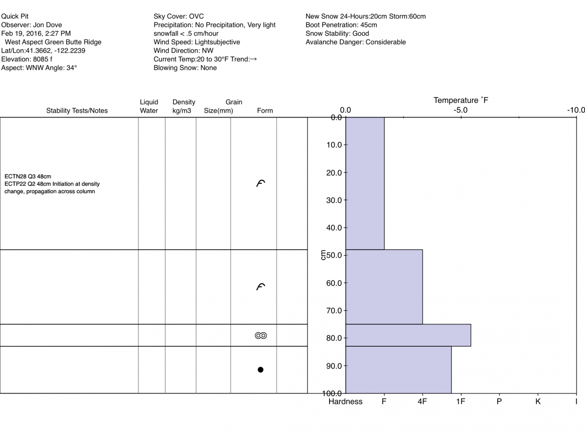
Photo of results from second extended column test performed in snow study pit, 2-19-2016 on WNW aspect of Green Butte Ridge (ECTP 22 Q2 48 cm deep at density change). Fracture circled in red with interface of new snow and old snow highlighted below:
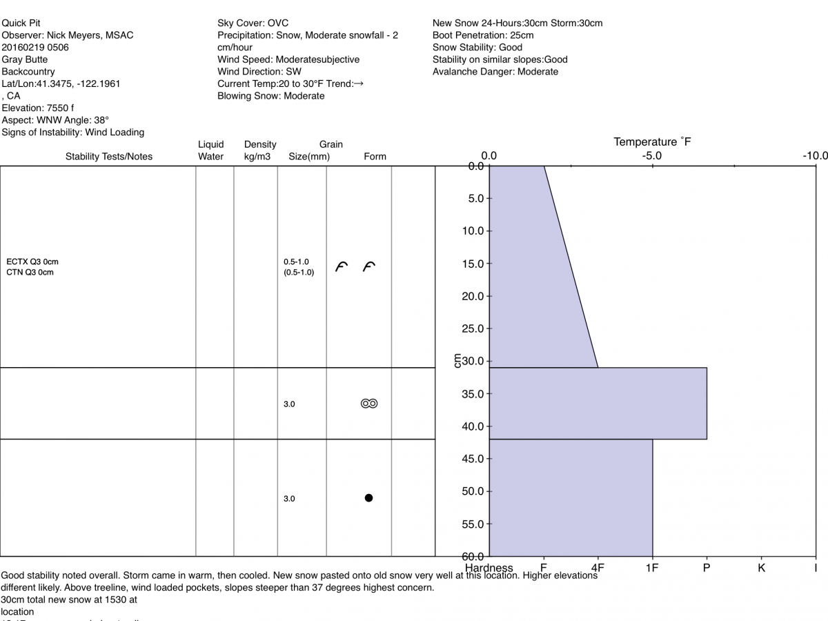
Pit Profile from Grey Butte on 2-18-2016:
________________________________________________________________________________________________________________________________________
LOCAL AREA ROAD, NORDIC and SNOWMOBILE PARK STATUS:
The Sand Flat cross country ski trails are in great shape and ready for your cross country skis or snow shoes. These are backcountry trails marked with blue diamonds on trees. Trails are not groomed. Snow shoers, please blaze a parallel trail to cross country skiers staying out of the skin track. These trails can be accessed via the Everett Memorial Highway. Thank you, and enjoy!
The Mt Shasta Nordic Center is open! These beautiful, groomed trails can be accessed via the Ski Park Highway. http://www.mtshastanordic.org
The Pilgrim Creek & Deer Mountain Snowmobile Parks are open! Trails are being groomed currently. Head to our "Education" tab on our website and find the snowmobile section for trail information, grooming status and other sledder resources!
The Castle Lake road is plowed to the lake. The Everett Memorial Highway is plowed to Bunny Flat.
The Five Red Flags of Avalanche Danger any time of year include: 1) Recent/current avalanche activity 2) Whumphing sounds or shooting cracks 3) Recent/current heavy snowfall 4) Strong winds transporting snow 5) Rapid warming or rain on snow.
Weather and Current Conditions
Weather Summary
Good Morning! In Mt Shasta City at 0500, we have a current temperature of 26 F, twelve degrees cooler than yesterday at this time. Clear skies and calm wind.
PLEASE NOTE: During the February 17th lightening activity, we lost all communications with our weather stations. Power has been compromised to the building on Gray Butte , where the base station exists for all our weather stations. We are working with Pacific Power and the US Forest Service tech's to get power restored as soon as possible. Thank you for understanding.
Below are a few nearby weather stations that are still up:
Sand Flat: 6,750 ft - the current temperature is 14 degrees F. Snow on the ground measures 95 inches with 5 inches new snow in the last 24 hours and little settlement. Temperatures have ranged from 14 F to 30 F.
Peterson Flat: 7,150 ft - the current temperature is 21 F. Snow on the ground measures 74 inches with 5 inches new snow in the last 24 hours. Temperatures have ranged from 20 F to 27 F.
-------------------------------------------------------------------------------------------------------------------------------------------------------------------
On Mt Shasta (South Side) in the last 24 hours...
Old Ski Bowl - 7,600 feet, the current temperature is XX degrees F. Snow on the ground totals XXX inches with XX new snow and XX settlement. Temperatures have ranged from XX F to XX F.
Grey Butte - 8,000 feet, the current temperature is XX degrees F. Temperatures have ranged from XX F to XX F. Winds have been averaging XX mph, XX in direction with a max gust to XX out of the XX
Mt Eddy Range (West side of Interstate-5)...
Castle Lake - 5,600 feet, the current temperature is XX degrees. Temperatures have ranged from XX F to XX F. Snow on the ground totals XX inches with XX new snow and X inch settlement.
Mt Eddy - 6,500 feet, the current temperature is XX degrees F. Temperatures have ranged from XX F to XX F. Snow on the ground measures XX inches with XX new snow and X inch of settlement. Winds have averaged X mph, XX in direction with a max gust of XX mph, out of the XX.
Always check the weather before you attempt to climb Mt Shasta. Further, monitor the weather as you climb. Becoming caught on the mountain in any type of weather can compromise life and limb. Be prepared.
| 0600 temperature: | 14 |
| Max. temperature in the last 24 hours: | 30 |
| Average wind direction during the last 24 hours: | west/northwest |
| Average wind speed during the last 24 hours: | 10-15 mph mi/hr |
| Maximum wind gust in the last 24 hours: | n/a mi/hr |
| New snowfall in the last 24 hours: | 3-5 inches |
| Total snow depth: | 95 inches |
Two Day Mountain Weather Forecast
Produced in partnership with the Medford NWS
| For 7000 ft to 9000 ft | |||
|---|---|---|---|
|
Saturday (4 a.m. to 10 p.m.) |
Saturday Night (10 p.m. to 4 a.m.) |
Sunday (4 a.m. to 10 p.m.) |
|
| Weather | Mostly sunny | Partly cloudy | Mostly sunny with increasing clouds. 10% chance of rain and snow showers after 4 pm. |
| Temperature (°F) | 38 | 26 | 42 |
| Wind (mi/hr) | Southeast 5-10 mph | South 5-10 mph | Southwest 5-10 mph |
| Precipitation SWE / Snowfall (in) | / 0 | / 0 | / 0 |
| For 9000 ft to 11000 ft | |||
| Saturday | Saturday Night | Sunday | |
| Weather | Mostly sunny and windy | Partly cloudy and windy | Mostly sunny with increasing clouds. 10% chance of snow showers after 4 pm. |
| Temperature (°F) | 22 | 22 | 24 |
| Wind (mi/hr) | West 15-20 mph with gusts to 30 | West 0 | West 30-35 mph with gusts to 45 mph |
| Precipitation SWE / Snowfall (in) | / 0 | / 0 | / 0 |

