

You are here
Avalanche Advisory for 2016-02-22 06:19:06
- EXPIRED ON February 23, 2016 @ 6:19 amPublished on February 22, 2016 @ 6:19 am
- Issued by Jon Dove - Shasta-Trinity National Forest
Bottom Line
Overall, LOW avalanche danger exists. Pockets of MODERATE avalanche danger will develop during the warmest parts of the day in the afternoon hours on E-SE-S-SW-W aspects, slopes 35 degrees and steeper. Human trigger of loose wet avalanches on sun exposed slopes will be a possibility today. Normal caution is advised.


Avalanche Problem 1: Loose Wet
-
Character ?

-
Aspect/Elevation ?
-
Likelihood ?CertainVery LikelyLikelyPossible
 Unlikely
 -
Size ?HistoricVery LargeLargeSmall

The unseasonably warm temperatures and ample sunshine combined with the recent snow accumulation will make for perfect conditions for loose wet snow instabilities to form today, tomorrow and later in the week. E-SE-S-SW-W aspects will be the most suspect during the warmest parts of the day. Enough snow may be entrained in a loose wet avalanche to bury a person if they are pushed into a terrain trap such as a gully bottom, or an abrupt transition such as a frozen lake surface at the bottom of a slope (think Castle Lake). Loose wet snow slides could also knock a person off of their feet and push them into undesirable terrain such as over a cliff band, strained through trees, or into rock outcroppings. Normal safe backcountry travel practices should be observed. Have good spacing between party members, cross suspect slopes one at a time, and have good communication amongst your group.
Forecast Discussion
High pressure and upper level ridging will continue to dominate the region through the work week. There are a couple of weak waves that will make a run at our area on Wednesday and Friday night, but the strength of the ridge will limit any potential for precipitation. We won't see any chance for significant amounts or precipitation until the coming weekend into early next week. Until then expect dry conditions and plenty of sunshine. Temperatures are forecast to increase today and Tuesday, and even into Wednesday staying at unseasonably warm levels. Winds will be moderate above treeline coming out of a northerly direction at speeds of 30-35 mph. Ridge top winds at higher elevations (12,000 ft.+) will see gusts of 45+ mph. The rather warm temperatures with lots of sunshine will make this week feel a bit spring like.
THIS SEASON PRECIPITATION for MT SHASTA CITY: Since October 1st (the wet season), we have received 25.36 inches of water, normal is 27.60 inches, putting us at 91% of normal. For the month of February we've received 2.87 inches of water, normal is 5.33 inches, putting us at 53% of normal, and finally... for the year of 2016 we've received 15.87 inches of water, normal is 12.39 inches, putting us at 128% of normal .
Recent Observations
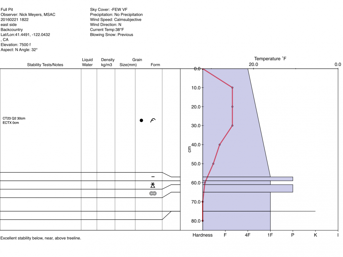
Yesterday an MSAC forecaster ventured out to the east side of our forecast area to make observations of the snowpack conditions. The only evidence of snow instability were some roller balls on east to south facing slopes around mid-day when temperatures were at their warmest. Winds increased in the afternoon coming out of the North, and high clouds began to stream over the area. Decent powder snow was still present on more northerly, shaded aspects making for good ski/board conditions. Snowmobilers had "high marked" and traversed on leeward, wind loaded slopes with no reaction from the snowpack. A snow study pit was dug, and a full pit profile taken (see graph below) on a north aspect at 7,500 feet with a slope angle of 32 degrees. An extended column stability test was performed resulting in a score of ECTX. A compression test was also performed resulting in a score of CT23 Q2 at 30 cm deep at a change in density. The forecasters opinion was that overall stable conditions exist.
For today, the biggest concern for any snow instabilities will be for wet loose snow avalanches, roller balls, pin wheels, and point release slough slides on E-SE-S-SW-W aspects during the warmest parts of the day. Day time warming over the next few days will be significant with unseasonably warm temperatures. Aspects where wet loose slides are common on Mt. Shasta are the SE aspect of Casaval ridge that drops into Avalanche Gulch, SE aspects in Sun Bowl and Powder Bowl, Right Peak in the Castle Lake area. Caution should be taken when choosing one's route of travel, especially in the afternoon hours due to loose wet instabilities. While not much of a problem themselves, they can entrain enough snow to be a hazard to backcountry travelers. They could knock one off of their feet, and push them over a cliff band, through tight trees, or into a terrain trap where enough snow could collect and fully bury a person.
Full Pit Profile from the east side of the forecast area on 2-21-2016:
Pit Profile from top of Grey Butte on 2-20-2016:
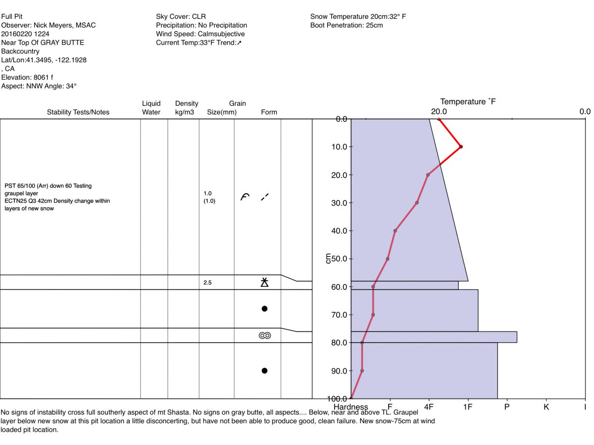
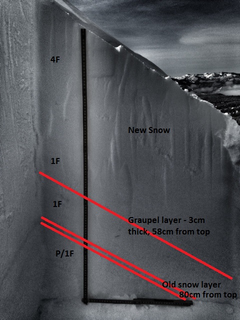
Photo of Grey Butte Pit Profile highlighting most recent snow layers:
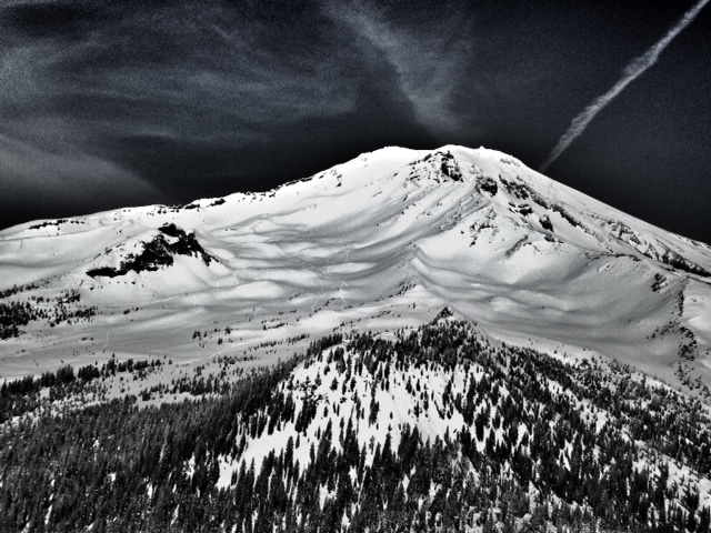
View of Old Ski Bowl, South side of Mt. Shasta, from the top of Grey Butte:
-------------------------------------------------------------------------------------------------------------------------------------------------------------------------------------------------------------
LOCAL AREA ROAD, NORDIC and SNOWMOBILE PARK STATUS:
The Sand Flat cross country ski trails are in great shape and ready for your cross country skis or snow shoes. These are backcountry trails marked with blue diamonds on trees. Trails are not groomed. Snow shoers, please blaze a parallel trail to cross country skiers staying out of the skin track. These trails can be accessed via the Everett Memorial Highway. Thank you, and enjoy!
The Mt Shasta Nordic Center is open! These beautiful, groomed trails can be accessed via the Ski Park Highway. http://www.mtshastanordic.org
The Pilgrim Creek & Deer Mountain Snowmobile Parks are open! Trails are being groomed currently. Head to our "Education" tab on our website and find the snowmobile section for trail information, grooming status and other sledder resources!
The Castle Lake road is plowed to the lake. The Everett Memorial Highway is plowed to Bunny Flat.
The Five Red Flags of Avalanche Danger any time of year include: 1) Recent/current avalanche activity 2) Whumphing sounds or shooting cracks 3) Recent/current heavy snowfall 4) Strong winds transporting snow 5) Rapid warming or rain on snow.
Weather and Current Conditions
Weather Summary
Good Morning! In Mt Shasta City at 0500, we have a current temperature of 37 F, nine degrees warmer than yesterday at this time. Mostly cloudy skies with light wind.
On Mt Shasta (South Side) in the last 24 hours...
Old Ski Bowl - 7,600 feet, the current temperature is 30 degrees F. Snow on the ground totals 126 inches with no new snow and 1 inch of settlement. Temperatures have ranged from 25 F to 40 F.
Grey Butte - 8,000 feet, the current temperature is 28 degrees F. Temperatures have ranged from 21 F to 33 F. Winds have been averaging 15-20 mph, west/northwest in direction with a max gust to 49 mph out of the NW.
Mt Eddy Range (West side of Interstate-5)...
Castle Lake - 5,600 feet, the current temperature is 27 degrees. Temperatures have ranged from 27 F to 51 F. Snow on the ground totals 70 inches with no new snow and 1 inch of settlement.
Mt Eddy - 6,500 feet, the current temperature is 29 degrees F. Temperatures have ranged from 24 F to 39 F. Snow on the ground measures 82 inches with no new snow and little settlement. Winds have averaged 3 mph, Variable in direction with a max gust of 7 mph, out of the SW.
Always check the weather before you attempt to climb Mt Shasta. Further, monitor the weather as you climb. Becoming caught on the mountain in any type of weather can compromise life and limb. Be prepared.
| 0600 temperature: | 22 |
| Max. temperature in the last 24 hours: | 40 |
| Average wind direction during the last 24 hours: | northwest |
| Average wind speed during the last 24 hours: | 15-20 mi/hr |
| Maximum wind gust in the last 24 hours: | 49 mi/hr |
| New snowfall in the last 24 hours: | 0 inches |
| Total snow depth: | 92 inches |
Two Day Mountain Weather Forecast
Produced in partnership with the Medford NWS
| For 7000 ft to 9000 ft | |||
|---|---|---|---|
|
Monday (4 a.m. to 10 p.m.) |
Monday Night (10 p.m. to 4 a.m.) |
Tuesday (4 a.m. to 10 p.m.) |
|
| Weather | Sunny | Mostly clear | Sunny |
| Temperature (°F) | 39 | 35 | 48 |
| Wind (mi/hr) | North 10-15 mph with gusts to 35 mph | Northeast 5-10 mph | Northeast 5-10 mph |
| Precipitation SWE / Snowfall (in) | / 0 | / 0 | / 0 |
| For 9000 ft to 11000 ft | |||
| Monday | Monday Night | Tuesday | |
| Weather | Sunny and windy | Mostly clear and windy | Sunny and breezy |
| Temperature (°F) | 26 | 26 | 32 |
| Wind (mi/hr) | Northwest 30-35 mph with higher gusts | Northwest 0 | Northwest 15-20 mph with gusts to 35 mph |
| Precipitation SWE / Snowfall (in) | / 0 | / 0 | / 0 |

