

You are here
Avalanche Advisory for 2016-02-24 06:30:55
- EXPIRED ON February 25, 2016 @ 6:30 amPublished on February 24, 2016 @ 6:30 am
- Issued by Nick Meyers - Shasta-Trinity National Forest
Bottom Line
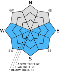
For today, the avalanche danger will be LOW during the morning hours. As daytime warming occurs, MODERATE avalanche danger is possible on E-SE-S-SW-W aspects on slopes steeper than 35 degrees due to loose wet avalanches. Small to medium size wind slabs may be encountered above treeline and on the upper mountain due to recent northerly winds.


Avalanche Problem 1: Loose Wet
-
Character ?

-
Aspect/Elevation ?
-
Likelihood ?CertainVery LikelyLikelyPossible
 Unlikely
 -
Size ?HistoricVery LargeLargeSmall

Most loose wet avalanches today will be in the form of human triggered roller balls, potentially forming into small point release style slides. Aspects E-SE-S-SW-W are slowly transitioning from the recent storm snow to melt/freeze conditions. Any wind on the snowpack, mainly above treeline, will help keep loose wet related instabilities at bay. Below and near treeline could be different where the snowpack is more protected from the cooling effects of wind.
Until a melt freeze crust is established, loose wet avalanches remain a concern.
Dig in the snow to identify where wet snow may sit on top of older dryer snow, where a solid melt/freeze process has yet to occur. Roller balls are an indicator that the snow is starting to loose strength and larger loose wet avalanches are possible.
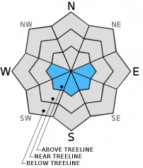
Avalanche Problem 2: Wind Slab
-
Character ?

-
Aspect/Elevation ?
-
Likelihood ?CertainVery LikelyLikelyPossible
Unlikely
-
Size ?HistoricVery LargeLargeSmall
Strong northerly winds on 2.22.16 were sending snow contrails billowing off of ridge tops above Shastina, the West Face, and the Red Banks. Snow was also visibly blowing across the Heart and upper Green Butte Ridge indicating the possibility for some mid-slope loading/cross loading as well. Despite multiple days of dry weather, it is important to remember that there is still loose, dry snow available for wind transport, especially at higher and cooler elevations. Wind slab development is likely in pockets around rock outcroppings just below ridge tops, the tops of chutes and couloirs, and mid-slope depressions and gullies. Lower wind speeds were recorded during the day at Grey Butte weather station, so formation of wind slabs will be confined to elevations of around 10,000 ft. and above on Mt. Shasta. Wind slab development may have occurred elsewhere in the forecast area, however, it will be limited to the highest leeward locations such as on Mt. Eddy and possibly Ash Creek Butte.
Forecast Discussion
Another temperature inversion in place this morning for the area... unseasonably warm temperatures, 10-15 degrees above normal, will host today's sunny skies and relatively mellow wind speeds. Mother Nature is taking a power nap currently and we hope she will make one last go of it in March! Climate experts believe March to be very wet based on past graphical data and current model outputs. Today, mostly clear skies and calm wind for the forecast area. Friday will present the next best chance at precipitation. Snow levels will start near 7,000 feet and lower to 4,000 to 5,000 feet by Saturday. Winds will also pick up later in the week out of the southwest. More on that later this week. Enjoy the beautiful day and try not to get recreationally stressed!
THIS SEASON PRECIPITATION for MT SHASTA CITY: Since October 1st (the wet season), we have received 25.36 inches of water, normal is 28.14 inches, putting us at 90% of normal. For the month of February we've received 2.87 inches of water, normal is 5.87 inches, putting us at 48% of normal, and finally... for the year of 2016 we've received 15.87 inches of water, normal is 12.93 inches, putting us at 122% of normal .
Recent Observations
Pretty good skiing of recycled powder and some mid-winter corn can be found out in the backcountry currently. We've had few observations submitted and that said, regarding snow stability, the old saying, "no news is good news" is the case. The snow stability has been excellent so most folks are simply just enjoying skiing and riding!
For today, our main concern for snow instabilities will continue to be for loose wet snow avalanches, roller balls, pinwheels, and point release slough slides on E-SE-S-SW-W aspects during the warmest parts of the day. Daytime warming will be significant with unseasonably warm temperatures. Aspects where loose wet slides are common on Mt. Shasta are the SE aspect of Casaval Ridge that drops into Avalanche Gulch, SE aspects in Sun Bowl and Powder Bowl, and Right Peak in the Castle Lake area.
Our second concern for today... On 2/22, strong northerly winds that affected elevations of 10,000 feet and above have likely developed new wind slab formations in pockets around rock outcroppings along and just below ridge tops (think Casaval Ridge), the tops of chutes and couloirs, and non-typical spots such as mid-slope depressions and gullies. It will be up to you to identify where new wind slabs have formed.
Full Pit Profile from the east side of the forecast area on 2-21-2016:
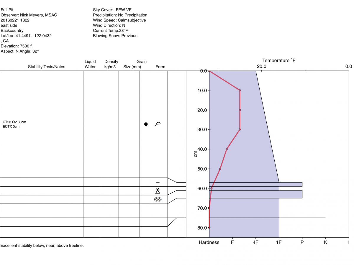
Photo of Grey Butte Pit Profile on 2-20-2016 highlighting the most recent snow layers:
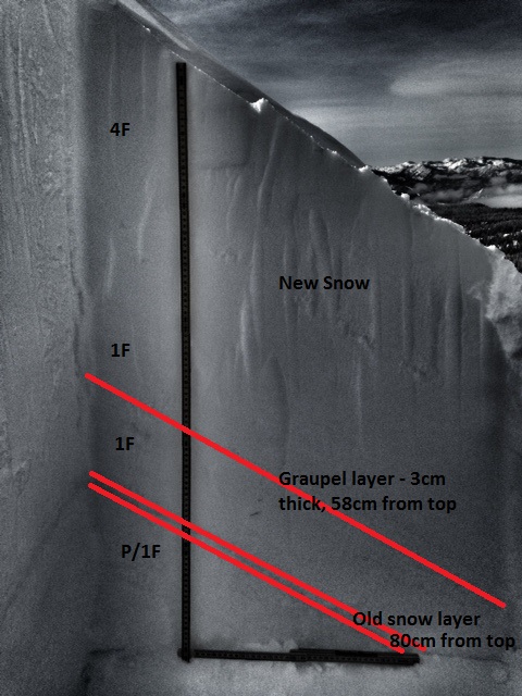
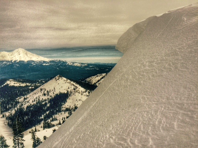
Photo: C. Carr, Shasta Mountain Guides
-----------------------------------------------------------------------------------------------------------------------------------------------------------
LOCAL AREA ROAD, NORDIC, AND SNOWMOBILE PARK STATUS:
The Sand Flat cross country ski trails are in good shape and ready for your cross country skis and snow shoes. These are backcountry routes marked with blue diamonds on trees. Trails are not groomed. Snow shoers, please blaze a parallel trail to cross country skiers staying out of the skin track. These trails can be accessed via the Everett Memorial Highway. Thank you, and enjoy!
The Mt. Shasta Nordic Center is open! These beautiful, groomed trails can be accessed via the Ski Park Highway. http://www.mtshastanordic.org
The Pilgrim Creek & Deer Mountain Snowmobile Parks are open! Trails have not been groomed in the past week and a half due to warm temperatures. Head to our "Education" tab on our website and find the snowmobile section for trail information, grooming status, and other sledder resources.
The Castle Lake Road is plowed to the lake. The Everett Memorial Highway is plowed to Bunny Flat.
The Five Red Flags of Avalanche Danger any time of year include: 1) Recent/current avalanche activity 2) Whumphing sounds or shooting cracks 3) Recent/current heavy snowfall 4) Strong winds transporting snow 5) Rapid warming or rain on snow.
Weather and Current Conditions
Weather Summary
Good Morning! In Mt Shasta City at 0500, we have a current temperature of 30 F, three degrees warmer than yesterday at this time, with clear skies and calm wind.
On Mt Shasta (South Side) in the last 24 hours...
Old Ski Bowl - 7,600 feet, the current temperature is 39 degrees F. Snow on the ground totals 123 inches with no new snow and 1 inch of settlement. Temperatures have ranged from 36 F to 53 F.
Grey Butte - 8,000 feet, the current temperature is 36 degrees F. Temperatures have ranged from 36 F to 50 F. Winds have averaged 10 mph out of the west/northwest with a max gust to 28 mph out of the east/northeast.
Mt Eddy Range (West side of Interstate-5)...
Castle Lake - 5,600 feet, the current temperature is 37 degrees. Temperatures have ranged from 34 F to 50 F. Snow on the ground totals 69 inches with no new snow and little settlement.
Mt Eddy - 6,500 feet, the current temperature is 36 degrees F. Temperatures have ranged from 33 F to 48 F. Snow on the ground measures 80 inches with no new snow and 1 inch of settlement. Winds have averaged 2 mph, Southerly in direction with a max gust of 7 mph, out of the east/southeast.
Always check the weather before you attempt to climb Mt Shasta. Further, monitor the weather as you climb. Becoming caught on the mountain in any type of weather can compromise life and limb. Be prepared.
| 0600 temperature: | 33 |
| Max. temperature in the last 24 hours: | 43 |
| Average wind direction during the last 24 hours: | West/Northwest |
| Average wind speed during the last 24 hours: | 5-10 mi/hr |
| Maximum wind gust in the last 24 hours: | 28 (Gray Butte) mi/hr |
| New snowfall in the last 24 hours: | 0 inches |
| Total snow depth: | 89 inches |
Two Day Mountain Weather Forecast
Produced in partnership with the Medford NWS
| For 7000 ft to 9000 ft | |||
|---|---|---|---|
|
Wednesday (4 a.m. to 10 p.m.) |
Wednesday Night (10 p.m. to 4 a.m.) |
Thursday (4 a.m. to 10 p.m.) |
|
| Weather | Mostly sunny | Partly cloudy | Sunny |
| Temperature (°F) | 48 | 32 | 51 |
| Wind (mi/hr) | Southeast/Southwest 5-10 mph | Southeast 5-10 mph | Southeast 5-10 mph |
| Precipitation SWE / Snowfall (in) | / 0 | / 0 | / 0 |
| For 9000 ft to 11000 ft | |||
| Wednesday | Wednesday Night | Thursday | |
| Weather | Mostly sunny and windy | Partly cloudy and breezy | Sunny and breezy |
| Temperature (°F) | 29 | 29 | 35 |
| Wind (mi/hr) | Southwest 5-15 mph with gusts to 20 mph | Southwest 0 | Southwest 10-20 mph with gusts to 30 mph |
| Precipitation SWE / Snowfall (in) | / 0 | / 0 | / 0 |

