

You are here
Avalanche Advisory for 2016-03-01 06:59:30
- EXPIRED ON March 2, 2016 @ 6:59 amPublished on March 1, 2016 @ 6:59 am
- Issued by Jon Dove - Shasta-Trinity National Forest
Bottom Line
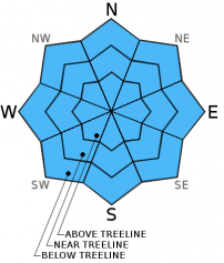
Overall, LOW avalanche danger will persist across the forecast area for all elevations and aspects. Snow instabilities will be few and far between. During the day, light rain is likely near and below treeline, but is not expected to affect the avalanche danger. A trace of snow is expected above treeline.
Normal caution is advised and safe travel techniques should be practiced.


Avalanche Problem 1: Normal Caution
-
Character ?

-
Aspect/Elevation ?
-
Likelihood ?CertainVery LikelyLikelyPossible
 Unlikely
 -
Size ?HistoricVery LargeLargeSmall

Normal caution will continue to be our travel advice for today. The only chance for snow instabilities will be isolated wind slabs which will be hard to find and stubborn to trigger. Wind slab formations from the scant amount of snow received this last Friday are widely spaced with poor uniformity and pose little threat. Triggering anything of size and consequence is slim to none. Increasing clouds, strong wind, and relatively cool temperatures will prevent any loose wet snow instabilities. It is always a smart idea to continue to practice safe travel techniques for backcountry travel even when that avalanche danger is low.
Forecast Discussion
A fast moving front will move over our area today bringing some light precipitation with rain falling up to around 7,500 feet. Gusty south winds will accompany this front with a wind advisory for today into this evening. Winds near and above treeline will reach speeds of close to 50 mph. Ridge top winds at higher elevations (10,000 feet and above) could possibly gust to near 70+ mph. This front will pass fairly quickly over our area moving to the east by this evening. A period of high pressure will follow bringing a brief spell of dry weather to the region on Wednesday. By Wednesday evening another round of precipitation is forecast, and it looks to be a bit heavier in amount of water produced. Snow levels will drop slightly on Thursday with snow levels predicted to be 5,500-6,500 feet. The "atmospheric river" event that was hinted at looks to becoming more of a reality with precipitation models showing close to 2 inches of water at the end of the week.
THIS SEASON PRECIPITATION for MT SHASTA CITY: Since October 1st (the wet season), we have received 25.52 inches of water, normal is 29.50 inches, putting us at 86% of normal. For the month of February we've received 3.03 inches of water, normal is 7.23 inches, putting us at 41% of normal, and finally... for the year of 2016 we've received 16.03 inches of water, normal is 14.29 inches, putting us at 112% of normal . -NO CHANGE DUE TO YESTERDAY BEING A LEAP YEAR DAY!
Recent Observations
Well, yesterday was unique due to being a leap year day. Other than that there is not much that sets it apart from the day before. Observations from the field are limited to what our weather stations have to say about the past 24 hours. Temperatures have warmed with overnight lows near treeline dipping to freezing or just below. Our bomber snowpack will show little signs of instability throughout the forecast area. The scattered "scabs" of wind buffed and sculpted snow will still be found above treeline interspersed amongst an otherwise firm and sometimes icy snow surface. Increasing clouds with the approaching front will bring rain to near and below treeline with trace amounts of snow above treeline. This weather system is not expected to change the avalanche danger today. Strong winds will prevent any significant snow accumulation. Thin, isolated wind slabs small in size may develop but will not pose a problem to backcountry travelers. Decreasing visibility and the power of the wind will prevent folks from venturing too high above treeline anyway.
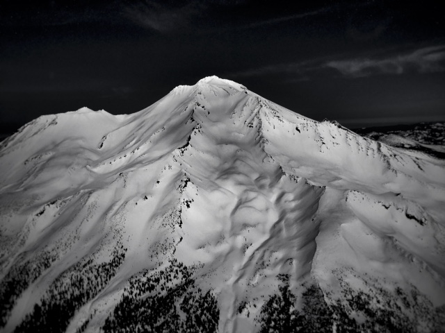
Aerial photo of Mt Shasta taken late February, 2016 by Jimmy Williams with his son Billy as pilot. Thanks for sharing you guys!
-----------------------------------------------------------------------------------------------------------------------------------------------------------
LOCAL AREA ROAD, NORDIC, AND SNOWMOBILE PARK STATUS:
The Sand Flat cross country ski trails are in good shape and ready for your cross country skis and snow shoes. These are backcountry routes marked with blue diamonds on trees. Trails are not groomed. Snow shoers, please blaze a parallel trail to cross country skiers staying out of the skin track. These trails can be accessed via the Everett Memorial Highway. Thank you, and enjoy!
The Mt. Shasta Nordic Center is open! These beautiful, groomed trails can be accessed via the Ski Park Highway. http://www.mtshastanordic.org
The Pilgrim Creek & Deer Mountain Snowmobile Parks are open! Trails have not been groomed in the past week and a half due to warm temperatures. Head to our "Education" tab on our website and find the snowmobile section for trail information, grooming status, and other sledder resources.
The Castle Lake Road is plowed to the lake. The Everett Memorial Highway is plowed to Bunny Flat.
The Five Red Flags of Avalanche Danger any time of year include: 1) Recent/current avalanche activity 2) Whumphing sounds or shooting cracks 3) Recent/current heavy snowfall 4) Strong winds transporting snow 5) Rapid warming or rain on snow.
Weather and Current Conditions
Weather Summary
Good Morning! In Mt Shasta City at 0500, we have a current temperature of 46 F, eighteen degrees warmer than yesterday at this time! Skies are overcast with calm wind.
On Mt Shasta (South Side) in the last 24 hours...
Old Ski Bowl - 7,600 feet, the current temperature is 34 degrees F. Snow on the ground totals 116 inches with no new snow and little settlement. Temperatures have ranged from 27 F to 41 F.
Gray Butte - 8,000 feet, the current temperature is 32 degrees F. Temperatures have ranged from 29 F to 37 F. Winds have averaged 15-20 mph and west/northwest in direction with a max gust to 49 mph west/northwest.
Mt Eddy Range (West side of Interstate-5)...
Castle Lake - 5,600 feet, the current temperature is 36 degrees. Temperatures have ranged from 32 F to 52 F. Snow on the ground totals 63 inches with no new snow and little settlement.
Mt Eddy - 6,500 feet, the current temperature is 36 degrees F. Temperatures have ranged from 27 F to 41 F. Snow on the ground measures 76 inches with no new snow and no settlement. Winds have averaged 2-3 mph, variable in nature with a max gust of 11 mph, south/southeast.
Always check the weather before you attempt to climb Mt Shasta. Further, monitor the weather as you climb. Becoming caught on the mountain in any type of weather can compromise life and limb. Be prepared.
| 0600 temperature: | 36 |
| Max. temperature in the last 24 hours: | 44 |
| Average wind direction during the last 24 hours: | West/northwest |
| Average wind speed during the last 24 hours: | 15-20 mi/hr |
| Maximum wind gust in the last 24 hours: | 49 (Gray Butte) mi/hr |
| New snowfall in the last 24 hours: | 0 inches |
| Total snow depth: | 81 inches |
Two Day Mountain Weather Forecast
Produced in partnership with the Medford NWS
| For 7000 ft to 9000 ft | |||
|---|---|---|---|
|
Tuesday (4 a.m. to 10 p.m.) |
Tuesday Night (10 p.m. to 4 a.m.) |
Wednesday (4 a.m. to 10 p.m.) |
|
| Weather | Partly cloudy this morning, then mostly cloudy with a 50% chance of rain this afternoon. Breezy | Mostly cloudy with a 60% percent chance of showers in the evening, then partly cloudy after midnight. | Partly cloudy with a 20% chance of rain in the afternoon. Windy. |
| Temperature (°F) | 40 | 34 | 45 |
| Wind (mi/hr) | South 15-25 with gusts to 50 mph | South 10-15 mph | South 10-15 mph increasing to 20-30 mph in the afternoon |
| Precipitation SWE / Snowfall (in) | / 0 | / 0 | / 0 |
| For 9000 ft to 11000 ft | |||
| Tuesday | Tuesday Night | Wednesday | |
| Weather | Partly cloudy this morning, then mostly cloudy with a 60% chance of snow after 10 am. Windy | Mostly cloudy with a 60% chance of snow showers before 10 pm, then partly cloudy after midnight. | Partly cloudy, then increasing clouds with a 20% chance of snow after 10 am. |
| Temperature (°F) | 29 | 25 | 32 |
| Wind (mi/hr) | Southwest 50-55 mph with gusts to 75 | West 0-1 | Southwest 35-40 mph with gusts to 55 |
| Precipitation SWE / Snowfall (in) | / 0-1 | / 0-1 | / 0 |

