

You are here
Avalanche Advisory for 2016-03-03 06:56:18
- EXPIRED ON March 4, 2016 @ 6:56 amPublished on March 3, 2016 @ 6:56 am
- Issued by Nick Meyers - Shasta-Trinity National Forest
Bottom Line
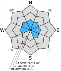
Overall, the avalanche danger is LOW for all aspects and elevations. However, pockets of MODERATE danger for newly formed, small wind slabs may exist on leeward W-NW-N-NE-E-SE facing slopes above treeline. A few inches of new snow above treeline with southwesterly winds could create small wind loaded pockets.
Normal caution is advised.


Avalanche Problem 1: Wind Slab
-
Character ?

-
Aspect/Elevation ?
-
Likelihood ?CertainVery LikelyLikelyPossible
 Unlikely
 -
Size ?HistoricVery LargeLargeSmall

Newly formed wind slabs, small in size, could be found above treeline today on W-NW-N-NE-E-SE facing slopes, but not limited too. Slabs will be small in size and hard to trigger. The overall snow conditions will likely be more like "dust on crust" but as one gains elevation, better accumulation might be found. The fresh wind deposits overlie what was already a variable snowpack consisting of isolated wind slabs, decomposing old snow, rain/sun crusts, wind crusts. Warm temperatures have encouraged good bonding and I don't forsee any consequential problems today due to wind slabs. In exposed terrain, expect to find significant variability in conditions, the presense or absence of fresh slabs, slab thickness, bonding at slab interface and stability over short distances. Watch for thin, soft and hard wind slabs beneath ridges, near prominent terrain features, in cross-loaded areas and lower on slopes below cliffs and on aprons. You might find buried graupel in concave areas where the slope angle eases, lower in cirques. Be cautious where slabs have formed above graupel layers. Check out the upper layers of the snowpack!
Forecast Discussion
Showers will linger into late morning today but trending toward a clearing phase. This will give you one last chance to wax up your boards or gas your snow machine because a band of moisture and the opening of the storm doors will begin Friday night. The first of a series of fronts will start friday night and be accompanied by strong south/southwest winds. A high wind watch is in effect for the area for Saturday. Snow levels are going to remain high until Sunday when cold air drops in from the north to help cool things off. Snow levels could lower below predicted levels this weekend due to intense rain fall. As we move into next week, temperatures fluctuate and thus with each of the storms that we get, snow levels are going to be the main variable.
THIS SEASON PRECIPITATION for MT SHASTA CITY: Since October 1st (the wet season), we have received 25.86 inches of water, normal is 30.03 inches, putting us at 86% of normal. For the month of March we've received .34 inches of water, normal is .53 inches, putting us at 64% of normal, and finally... for the year of 2016 we've received 16.37 inches of water, normal is 14.82 inches, putting us at 110% of normal .
Recent Observations
A warm blast of weather came through yesterday and temps are a few degrees warmer this morning...the Old Ski Bowl weather station recorded .80 inches of precipitation over the last 24 hours, but we only saw 1-2 inches of new snow at 8,000 feet. Temps did not drop below freezing at 8,000 feet until about midnight. Temperatures did NOT drop below freezing at all at Castle Lake and Mt Eddy areas and thus rain on snow occurred. This shrank the snowpack in those areas by several inches. So... it's still not quite a powder day. With only a couple inches new snow recorded, windy southwesterlies and a highly variable old snow surface, I suspect it still remains a mixed bag. Snow surface conditions vary from scattered scabs of wind buffed snow, rippled snow dunes to icy old snow. Thin, isolated wind slabs small in size may be found but are not expected to pose a problem to backcountry travelers today. Low lying gullies might have accumulated a bit more snow and smoothed things out. Report your observations or send us a picture!
-----------------------------------------------------------------------------------------------------------------------------------------------------------
LOCAL AREA ROAD, NORDIC, AND SNOWMOBILE PARK STATUS:
The Sand Flat cross country ski trails are in good shape and ready for your cross country skis and snow shoes. These are backcountry routes marked with blue diamonds on trees. Trails are not groomed. Snow shoers, please blaze a parallel trail to cross country skiers staying out of the skin track. These trails can be accessed via the Everett Memorial Highway. Thank you, and enjoy!
The Mt. Shasta Nordic Center is open! These beautiful, groomed trails can be accessed via the Ski Park Highway. http://www.mtshastanordic.org
The Pilgrim Creek & Deer Mountain Snowmobile Parks are open! Trails have not been groomed in the past week and a half due to warm temperatures. Head to our "Education" tab on our website and find the snowmobile section for trail information, grooming status, and other sledder resources.
The Castle Lake Road is plowed to the lake. The Everett Memorial Highway is plowed to Bunny Flat.
The Five Red Flags of Avalanche Danger any time of year include: 1) Recent/current avalanche activity 2) Whumphing sounds or shooting cracks 3) Recent/current heavy snowfall 4) Strong winds transporting snow 5) Rapid warming or rain on snow.
Weather and Current Conditions
Weather Summary
Good Morning! In Mt Shasta City at 0500, we have a current temperature of 46 F, nine degrees warmer than yesterday at this time. Skies are cloudy with light rain at times and breezy.
On Mt Shasta (South Side) in the last 24 hours...
Old Ski Bowl - 7,600 feet, the current temperature is 31 degrees F. Snow on the ground totals 116 inches with 1-2 inches new snow and two inches of settlement due to rain on snow. Temperatures have ranged from 28 F to 42 F. Temperatures did not drop below freezing until about midnight.
Gray Butte - 8,000 feet, the current temperature is 30 degrees F. Temperatures have ranged from 23 F to 35 F. Winds have averaged 10-15 mph with a max gust to 42 mph, southwest.
Mt Eddy Range (West side of Interstate-5)...
Castle Lake - 5,600 feet, the current temperature is 36 degrees. Temperatures have ranged from 35 F to 42 F. Snow on the ground totals 60 inches with no new snow and 2-3 inches of settlement due to rain on snow and warm temps.
Mt Eddy - 6,500 feet, the current temperature is 34 degrees F. Temperatures have ranged from 30 F to 39 F. Snow on the ground measures 72 inches with no new snow and 5 inches settlement due to rain on snow and warm temps. Winds have averaged 2-3 mph with a max gust of 14 mph, southwest.
Always check the weather before you attempt to climb Mt Shasta. Further, monitor the weather as you climb. Becoming caught on the mountain in any type of weather can compromise life and limb. Be prepared.
| 0600 temperature: | 34 |
| Max. temperature in the last 24 hours: | 40 |
| Average wind direction during the last 24 hours: | Southwest |
| Average wind speed during the last 24 hours: | 10-15 mi/hr |
| Maximum wind gust in the last 24 hours: | 42 (Gray Butte) mi/hr |
| New snowfall in the last 24 hours: | 1-2 inches |
| Total snow depth: | 79 inches |
Two Day Mountain Weather Forecast
Produced in partnership with the Medford NWS
| For 7000 ft to 9000 ft | |||
|---|---|---|---|
|
Thursday (4 a.m. to 10 p.m.) |
Thursday Night (10 p.m. to 4 a.m.) |
Friday (4 a.m. to 10 p.m.) |
|
| Weather | Rain showers likely before 10am, then a slight chance of rain and snow showers. Mostly cloudy | A chance of rain and snow showers before 4am, then a chance of snow showers. Mostly cloudy | A chance of snow before 10am, then rain and snow. Breezy |
| Temperature (°F) | 42 | 30 | 43 |
| Wind (mi/hr) | South 10-15 mph with gusts higher | South 10-15 mph with gusts higher | South 10-15 mph with gusts higher |
| Precipitation SWE / Snowfall (in) | / 0-.5 | / 0-.5 | / 0-.5 |
| For 9000 ft to 11000 ft | |||
| Thursday | Thursday Night | Friday | |
| Weather | Snow showers likely, mainly before 10am. Mostly cloudy, windy. Wind chill values as low as -1. | A chance of snow showers, mainly between 10pm and 4am, then a chance of snow after 4am. Mostly cloudy | Snow, mainly after 10am. High near 27. Windy |
| Temperature (°F) | 24 | 24 | 27 |
| Wind (mi/hr) | Southwest 30-40 mph | Southwest 1-2 | Southwest 40-50 mph |
| Precipitation SWE / Snowfall (in) | / 1-2 | / 0-.5 | / 2-4 |

