

You are here
Avalanche Advisory for 2016-03-05 07:00:58
- EXPIRED ON March 6, 2016 @ 7:00 amPublished on March 5, 2016 @ 7:00 am
- Issued by Jon Dove - Shasta-Trinity National Forest
Bottom Line
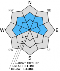
MODERATE avalanche danger exists near and above treeline for storm and wind slabs. Pockets of CONSIDERABLE danger exist in isolated areas above treeline on slopes 35 degrees and steeper on leeward W-NW-N-NE-E aspects. Human trigger of wind slabs in these areas will be likely.
LOW avalanche danger exists below treeline due to warm temperatures and rain. Avalanche danger will increase with more snow and wind over the weekend. Carful snowpack evaluation, cautious route finding, conservative decision making essential.


Avalanche Problem 1: Wind Slab
-
Character ?

-
Aspect/Elevation ?
-
Likelihood ?CertainVery LikelyLikelyPossible
 Unlikely
 -
Size ?HistoricVery LargeLargeSmall

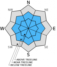
Strong southerly winds, increasing in strength today will develop wind slabs small to medium in size on leeward W-NW-N-NE-E aspects near and above treeline. Wind slabs will continue to build in size and distribution as we receive more snow over the course of the day, tonight, and tomorrow. Wind slabs will be found in the typical starting zones along ridge tops, the tops of chutes and couloirs, around rock outcroppings, and in gully bottoms. Due to the intensity of the winds at higher elevations wind slabs will also develop in non-tyical areas such as mid-slop depressions, and the sides of moraines and gullies. Human trigger of wind slab avalanches will be likely above treeline in isolated areas, on slopes 35 degrees and steeper. Human trigger will be possible near treeline.
Avalanche Problem 2: Storm Slab
-
Character ?

-
Aspect/Elevation ?
-
Likelihood ?CertainVery LikelyLikelyPossible
Unlikely
-
Size ?HistoricVery LargeLargeSmall
New storm slabs have, and will continue to develop today near and above treeline. The heavy and wet nature of the new snow will help it to bond to the old snow surface. That being said, the old snow is firm and will provide a nice bed surface for a slab to slide on. As the new snow piles up, and temperatures decrease as the weekend progresses sensitivity of storm slab failure will mostly likely lie at changes in density in the new snow. Human trigger of storm slabs will be possible. The strong southerly winds may limit the size of new storm slab development above treeline at higher elevations, but they will still be present. Evaluate the snow and terrain carefully, identify slopes and features of concern, and avoid them. Time to be cautious out there.
Forecast Discussion
Let the games begin! The Mount Shasta area is in the cross hairs with winter weather aimed right at us. The next in line of a series of very wet and windy storm systems is making it's way on shore this morning, and is steaming our way. A "high wind warning" has been issued for our area today into tonight with the coming front. Southerly winds with speeds of 35-45 mph will be found near and above treeline with gusts of close to hurricane force possible today, especially along exposed ridge tops at 9,000 feet and above. Generous amounts of water will be brought to the region with periods of heavy precipitation. Snow levels will hover around 7,000 feet today, and will slowly drop. By Sunday evening the snow levels will be around 4,000-5,000 feet. Precipitation amounts will decrease slightly, then ramp back up late Sunday afternoon into Sunday night. Bottom line is, the weekend will be wet with snow levels starting relatively high, then dropping as systems pass leaving us with a "right side up" nature to the new snow received. So, get your skis shined up and grab a stick of Juicy Fruit cause the winds will be sure to move ya!
THIS SEASON PRECIPITATION for MT SHASTA CITY: Since October 1st (the wet season), we have received 26.30 inches of water, normal is 30.53 inches, putting us at 86% of normal. For the month of March we've received 0.78 inches of water, normal is 1.03 inches, putting us at 75% of normal, and finally... for the year of 2016 we've received 16.81 inches of water, normal is 15.32 inches, putting us at 109% of normal .
Recent Observations
Rain began to fall yesterday with snow levels reaching up to just over 8,000 feet. In the last 24 hours Old Ski Bowl weather station recorded total water amounts of slightly more than 1.5 inches of water. New snow amounts, however, have totaled only about 3 inches of heavy and wet Cascade crud near treeline. Temperatures are set to rise slightly as the day warms up keeping snow levels hovering around 7,000 feet, and possibly a bit higher. Low avalanche danger will exist below treeline throughout the forecast area due to rain, possibly heavy at times, with maybe some heavy snow mixed in up on Mt. Shasta. Near and above treeline will offer the best chance for finding new snow to ski/ride on. That being said, strong southerly winds and poor visibility will deter anyone from venturing beyond treeline. The significant amounts of precipitation have, and will continue to form new storm and wind slabs. Despite the fact that the heavy and wet nature of the new snow will help glue it on to the old snow surface, human trigger of said avalanche problems will be possible today. Above treeline on leeward W-NW-N-NE-E aspects, along ridge tops, the tops of chutes and couloirs, and around rock outcroppings wind slabs of small to medium size will have formed. Due to the increasing strength of southerly winds, wind slabs will also develop in non-typical starting zones such as mid-slope depressions and along gullies as well. In these locations human trigger of wind slabs may be likely. As the snow level drops tonight and Sunday, with more snow on tap, avalanche danger will increase at all elevations and aspects. It's time to power up you avalanche radar. Safe travel techniques are mandatory, careful snowpack evaluation is a must, and cautious decision making should be practiced. We are all stoked for Powder's return, but all the new snow is sitting on a nice firm bed surface and avalanche conditions will be ripe for the picking, or avoiding, rather.
-----------------------------------------------------------------------------------------------------------------------------------------------------------
LOCAL AREA ROAD, NORDIC, AND SNOWMOBILE PARK STATUS:
The Sand Flat cross country ski trails are in good shape and ready for your cross country skis and snow shoes. These are backcountry routes marked with blue diamonds on trees. Trails are not groomed. Snow shoers, please blaze a parallel trail to cross country skiers staying out of the skin track. These trails can be accessed via the Everett Memorial Highway. Thank you, and enjoy!
The Mt. Shasta Nordic Center is open! These beautiful, groomed trails can be accessed via the Ski Park Highway. http://www.mtshastanordic.org
The Pilgrim Creek & Deer Mountain Snowmobile Parks are open! Trails have not been groomed in the past week and a half due to warm temperatures. Head to our "Education" tab on our website and find the snowmobile section for trail information, grooming status, and other sledder resources.
The Castle Lake Road is plowed to the lake. The Everett Memorial Highway is plowed to Bunny Flat.
The Five Red Flags of Avalanche Danger any time of year include: 1) Recent/current avalanche activity 2) Whumphing sounds or shooting cracks 3) Recent/current heavy snowfall 4) Strong winds transporting snow 5) Rapid warming or rain on snow.
Weather and Current Conditions
Weather Summary
Good Morning! In Mt Shasta City at 0500, we have a current temperature of 46 F, the same temperature as yesterday at this time. Winds are light at 5 mph and skies are mostly cloudy with light rain.
On Mt Shasta (South Side) in the last 24 hours...
Old Ski Bowl - 7,600 feet, the current temperature is 31 degrees F. Snow on the ground totals 117 inches with 2 inches of new snow and no settlement. Temperatures have ranged from 28 F to 35 F.
Gray Butte - 8,000 feet, the current temperature is 31 degrees F. Temperatures have ranged from 28 F to 33 F. Winds have averaged 10-15 mph with a max gust to 35 mph, south/southeast.
Mt Eddy Range (West side of Interstate-5)...
Castle Lake - 5,600 feet, the current temperature is 37 degrees. Temperatures have ranged from 34 F to 40 F. Snow on the ground totals 58 inches with no new snow and 2 inches of settlement.
Mt Eddy - 6,500 feet, the current temperature is 34 degrees F. Temperatures have ranged from 32 F to 39 F. Snow on the ground measures 72 inches with no new snow and 2 inches of settlement. Winds have averaged 2 mph with a max gust of 21 mph, south.
Always check the weather before you attempt to climb Mt Shasta. Further, monitor the weather as you climb. Becoming caught on the mountain in any type of weather can compromise life and limb. Be prepared.
| 0600 temperature: | 33 |
| Max. temperature in the last 24 hours: | 40 |
| Average wind direction during the last 24 hours: | Southerly |
| Average wind speed during the last 24 hours: | 10-15 mi/hr |
| Maximum wind gust in the last 24 hours: | 35 (Gray Butte) mi/hr |
| New snowfall in the last 24 hours: | 0 inches |
| Total snow depth: | 77 inches |
Two Day Mountain Weather Forecast
Produced in partnership with the Medford NWS
| For 7000 ft to 9000 ft | |||
|---|---|---|---|
|
Saturday (4 a.m. to 10 p.m.) |
Saturday Night (10 p.m. to 4 a.m.) |
Sunday (4 a.m. to 10 p.m.) |
|
| Weather | Cloudy with rain. Rain could be heavy at times. Windy | Cloudy. Rain/snow before 10 pm then snow showers. Rain/snow could be heavy at times. WIndy | Cloudy with snow showers. The snow could be heavy at times. |
| Temperature (°F) | 42 | 29 | 30 |
| Wind (mi/hr) | South 25-35 with gusts to 50 mph, increasing to 30-45 mph with gusts close to 75 mph this afternoon. | South becoming Southwest after midnight 30-45 mph, decreasing to 10-20 mph after midnight | South 10-20 mph |
| Precipitation SWE / Snowfall (in) | / 1-2 of water | / 1-3 | / 3-5 |
| For 9000 ft to 11000 ft | |||
| Saturday | Saturday Night | Sunday | |
| Weather | Cloudy with snow. The snow could be heavy at times. Windy | Cloudy with snow before 10 pm, then snow showers after 10 pm. The snow could be heavy at times. Windy with wind chill values as low as -15. | Cloudy with snow showers. The snow could be heavy at times. Windy with wind chill values as low as -18. |
| Temperature (°F) | 27 | 10 | 11 |
| Wind (mi/hr) | South 25-35 mph with gusts to 50 mph, increasing to 45-55 mph with gusts to 75+ mph | Southwest 12-18 | Southwest 30-35 mph |
| Precipitation SWE / Snowfall (in) | / 12-18 | / 10-14 | / 6-10 |

