

You are here
Avalanche Advisory for 2016-03-06 06:30:39
- EXPIRED ON March 7, 2016 @ 6:30 amPublished on March 6, 2016 @ 6:30 am
- Issued by Jon Dove - Shasta-Trinity National Forest
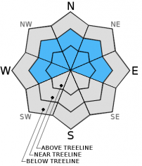
Bottom Line
Overall, MODERATE avalanche danger exists throughout the forecast area. CONSIDERABLE danger exists above treeline for storm and wind slabs on slopes 35 degrees and steeper. Wind slabs will be found on leeward W-NW-N-NE-E-SE aspects. Human trigger of wind slabs in these areas will be likely.
LOW avalanche danger exists below treeline due to high snow levels. Avalanche danger will increase with additional snow near and below treeline. Carful snowpack evaluation, cautious route finding, conservative decision making essential.


Avalanche Problem 1: Wind Slab
-
Character ?

-
Aspect/Elevation ?
-
Likelihood ?CertainVery LikelyLikelyPossible
 Unlikely
 -
Size ?HistoricVery LargeLargeSmall

Strong southerly winds yesterday have developed wind slabs medium in size on leeward W-NW-N-NE-E-SE aspects near and above treeline. Wind slabs will continue to build in size and distribution as we receive more snow later today into tonight as southerly winds pick back up with the next storm system. They will be found in the typical starting zones along ridge tops, around rock outcroppings, the tops of chutes, and in gully bottoms. Due to the intensity of the winds at higher elevations wind slabs will have also developed in non-typical starting zones such as mid-slop depressions, and the sides of moraines. Human trigger of wind slab avalanches will be likely above treeline at elevations of 8,000 feet and above in isolated areas, on slopes 35 degrees and steeper. Human trigger will also be possible near treeline, as well. Look for obvious signs of wind slab development such as smooth and rounded formations, sometimes hollow sounding. They can be soft to hard in density.
Avalanche Problem 2: Storm Slab
-
Character ?

-
Aspect/Elevation ?
-
Likelihood ?CertainVery LikelyLikelyPossible
Unlikely
-
Size ?HistoricVery LargeLargeSmall
Storm slabs have, and will continue to develop with new snow forecast for later today and tonight near and above treeline. New storm slabs may develop below treeline as snow levels drop with this incoming storm system. The heavy and wet nature of the new snow has helped it to bond to the old snow surface. The old snow surface that lies below the new snow is firm and will provide a nice bed surface for a slab to slide on. As additional new snow is added, and temperatures decrease as the next system passes sensitivity of storm slab failure will mostly likely lie at changes in density within the new snow. Human trigger of storm slabs will be possible near and above treeline, and potentially below treeline toward the tail end of the storm. The strong southerly winds may have limited the size of new storm slab development above treeline at higher elevations, but they will still be present. Evaluate the snow and terrain carefully, identify slopes and features of concern, and avoid them. Don't let the excitement of powder snow lead you to complacency.
Forecast Discussion
Well, that was a wet one. Yesterday surely delivered in the precipitation department. Unfortunately, the snow levels remained slightly higher than expected with rain falling almost to 8,000 feet. A pause in the stormy weather is happening this morning with partly cloudy skies. A cold air mass has moved in behind the front dropping temperatures across the forecast area. Low pressure will swing up from the Southwest as the next system begins to kick up another round of precipitation later today into tonight. Showers will continue behind this system, lingering into Monday, then slowly tapering off by Monday afternoon. Snow levels for today will hover around 6,500-7,000 feet, then dropping overnight to 3,000-3,500 feet. There is a chance for a snowflake or two to fall in Mt. Shasta City. Winds will pick back up with the approaching storm system this afternoon coming out of a southerly direction. They will then shift to the northwest on Monday as the system passes. Wind speeds above treeline today will measure 35-45 mph with higher gusts possible, especially along ridge tops and other exposed areas.
THIS SEASON PRECIPITATION for MT SHASTA CITY: Since October 1st (the wet season), we have received 28.87 inches of water, normal is 30.77 inches, putting us at 93% of normal. For the month of March we've received 3.35 inches of water, normal is 1.27 inches, putting us at 263% of normal, and finally... for the year of 2016 we've received 19.38 inches of water, normal is 15.56 inches, putting us at 124% of normal .
Recent Observations
Heavy rain fell yesterday with snow levels reaching up to close to 8,000 feet. In the last 24 hours the tipping bucket at the Old Ski Bowl weather station recorded total water amounts of slightly more than 3 inches of water. Temperatures have dropped noticeably with a cold air mass that has moved in behind yesterday's storm front. Cooling has been promoted as the clouds have broken allowing residual heat to escape. The next storm system will begin to roll over the area later today bringing more precipitation with lowering snow levels. For those who braved the rain, soggy and wet conditions were found below treeline with no signs of instabilities reported. New snow was not encountered until one made it above treeline. Conditions from treeline up, however, were quite inhospitable due to poor visibility and howling southerly winds. A brief break in the weather this morning may draw skiers/riders above treeline where new storm and wind slabs have developed. Caution should be taken in choosing you route today if you venture above 8,000 feet. Keep your eyes peeled for wind slabs and avoid them. Wind slabs will exist on leeward W-NW-N-NE-E-SE aspects, and will be small to medium in size. Human trigger of wind slabs will be likely, especially at higher elevations. They will be found in the typical areas such as along ridge tops, around rock outcroppings, the tops of chutes, and in depressions and gullies. The strong nature of the winds will have developed wind slabs in other non-typical starting zones such as mid-slope depressions, and along the sides of moraines. Careful snowpack evaluation, cautious route finding, and conservative decision making is advised for all above treeline terrain above 8,000 feet. Wind slabs and storm slabs will continue to develop with the next storm system later today.
-----------------------------------------------------------------------------------------------------------------------------------------------------------
LOCAL AREA ROAD, NORDIC, AND SNOWMOBILE PARK STATUS:
The Sand Flat cross country ski trails are in good shape and ready for your cross country skis and snow shoes. These are backcountry routes marked with blue diamonds on trees. Trails are not groomed. Snow shoers, please blaze a parallel trail to cross country skiers staying out of the skin track. These trails can be accessed via the Everett Memorial Highway. Thank you, and enjoy!
The Mt. Shasta Nordic Center is open! These beautiful, groomed trails can be accessed via the Ski Park Highway. http://www.mtshastanordic.org
The Pilgrim Creek & Deer Mountain Snowmobile Parks are open! Trails have not been groomed in the past week and a half due to warm temperatures. Head to our "Education" tab on our website and find the snowmobile section for trail information, grooming status, and other sledder resources.
The Castle Lake Road is plowed to the lake. The Everett Memorial Highway is plowed to Bunny Flat.
The Five Red Flags of Avalanche Danger any time of year include: 1) Recent/current avalanche activity 2) Whumphing sounds or shooting cracks 3) Recent/current heavy snowfall 4) Strong winds transporting snow 5) Rapid warming or rain on snow.
Weather and Current Conditions
Weather Summary
Good Morning! In Mt Shasta City at 0500, we have a current temperature of 37 F, nine degrees cooler than yesterday at this time. Skies are partly cloudy with calm wind.
On Mt Shasta (South Side) in the last 24 hours...
Old Ski Bowl - 7,600 feet, the current temperature is 22 degrees F. Snow on the ground totals 119 inches with 2 inches of new snow and no settlement. Temperatures have ranged from 22 F to 34 F.
Gray Butte - 8,000 feet, the current temperature is 21 degrees F. Temperatures have ranged from 21 F to 33 F. Winds have averaged 20-25 mph southerly in nature, shifting to west/northwest after 2200, with a max gust to 56 mph, south/southeast.
Mt Eddy Range (West side of Interstate-5)...
Castle Lake - 5,600 feet, the current temperature is 26 degrees. Temperatures have ranged from 26 F to 39 F. Snow on the ground totals 56 inches with no new snow and 2 inches of settlement.
Mt Eddy - 6,500 feet, the current temperature is 24 degrees F. Temperatures have ranged from 24 F to 37 F. Snow on the ground measures 73 inches with 1 inch of new snow and no settlement. Winds have averaged 4 mph with a max gust of 29 mph, west/southwest. It appears the anemometer has stopped working at 2 am this morning. We will be monitoring.
Always check the weather before you attempt to climb Mt Shasta. Further, monitor the weather as you climb. Becoming caught on the mountain in any type of weather can compromise life and limb. Be prepared.
| 0600 temperature: | 28 |
| Max. temperature in the last 24 hours: | 38 |
| Average wind direction during the last 24 hours: | Southerly until 2200 shifting to West/northwest |
| Average wind speed during the last 24 hours: | 20-25 mi/hr |
| Maximum wind gust in the last 24 hours: | 56 (Gray Butte) mi/hr |
| New snowfall in the last 24 hours: | 0 inches |
| Total snow depth: | 75 inches |
Two Day Mountain Weather Forecast
Produced in partnership with the Medford NWS
| For 7000 ft to 9000 ft | |||
|---|---|---|---|
|
Sunday (4 a.m. to 10 p.m.) |
Sunday Night (10 p.m. to 4 a.m.) |
Monday (4 a.m. to 10 p.m.) |
|
| Weather | Cloudy with snow showers. The snow could be heavy at times. Breezy. | Cloudy with snow showers, mainly before 10 pm. The snow could be heavy at times. Windy with wind chill values as low as -3. | Mostly cloudy with a 50% chance of snow showers, mainly before 4 pm. |
| Temperature (°F) | 35 | 17 | 35 |
| Wind (mi/hr) | Southwest shifting to South 10-15 mph increasing to 15-25 mph this afternoon with gusts to 40 mph | South becoming southwest after midnight 20-30 mph decreasing to 10-15 mph after midnight | Northwest 5-10 mph |
| Precipitation SWE / Snowfall (in) | / 3-7 | / 8-12 | / 0-.5 |
| For 9000 ft to 11000 ft | |||
| Sunday | Sunday Night | Monday | |
| Weather | Cloudy with snow showers. The snow could be heavy at times. Windy with wind chill values as low as -13. | Cloudy with snow showers, mainly before 10 pm. The snow could be heavy at times. Windy with wind chill values as low as -19. | Mostly cloudy with a 50% chance of snow showers, mainly before 4 pm. Blustery with wind chill values as low as -14. |
| Temperature (°F) | 12 | 8 | 9 |
| Wind (mi/hr) | Southwest 25-30 mph increasing to 35-45 in the afternoon. Higher gusts possible. | Southwest 8-12 | Northwest 20-25 mph |
| Precipitation SWE / Snowfall (in) | / 8-12 | / 13-19 | / 0-1 |

