

You are here
Avalanche Advisory for 2016-03-07 06:58:35
- EXPIRED ON March 8, 2016 @ 6:58 amPublished on March 7, 2016 @ 6:58 am
- Issued by Jon Dove - Shasta-Trinity National Forest
Bottom Line
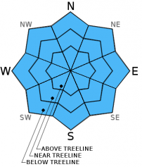
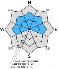
Overall, CONSIDERABLE avalanche danger exists for soft storm slabs and wind slabs above treeline, and pockets near treeline on leeward W-NW-N-NE-E aspects. MODERATE avalanche danger exists below treeline for new storm slabs. Size and distribution of wind slabs and their sensitivity to trigger is uncertain. Rapid snow accumulation of 13-18 inches is a definite Red Flag. Evaluate the snowpack, identify features of concern before committing to a slope and avoid them, use conservative decision making.


Avalanche Problem 1: Storm Slab
-
Character ?

-
Aspect/Elevation ?
-
Likelihood ?CertainVery LikelyLikelyPossible
 Unlikely
 -
Size ?HistoricVery LargeLargeSmall

Soft storm slabs have developed with the ample amount of light and dry snow that stacked up quickly during yesterday's storm. Measurements of 13-18 inches of new snow were recorded by weather stations on Mt. Shasta, Castle lake, and Mt. Eddy. These soft slabs will be found at all elevations due to the relatively light winds. The lack of wind influence has allowed the new snow to accumulate without being transported around to a large degree. Slabs of over a foot in depth exist throughout our forecast area. Weakness will lie at the interface of the new snow and the heavy wet snow that fell on Saturday near and above treeline. Below treeline the new snow is resting mainly on the old snow surface that is saturated with rain water. Moderate to considerable avalanche danger will be found at all locations, so safe travel techniques are absolutely mandatory today. Evaluate the snow, identify features of concern before committing to a slope, and use conservative decision making. Human trigger of storm slabs will be possible below, near, and above treeline today.
Avalanche Problem 2: Wind Slab
-
Character ?

-
Aspect/Elevation ?
-
Likelihood ?CertainVery LikelyLikelyPossible
Unlikely
-
Size ?HistoricVery LargeLargeSmall
Winds with yesterday's storm were light and allowed snow to accumulate with out to much wind transport. Wind slabs that developed with Saturday's storm are now covered by all the light and dry new snow. That being said, there was still some light wind with occasional moderate gusts, so new wind slabs of small size may have developed on leeward W-NW-N-NE-E aspects near and above treeline. Below treeline wind slab development is unlikely. The sensitivity to trigger of new wind slabs in uncertain.
Avalanche Problem 3: Loose Dry
-
Character ?

-
Aspect/Elevation ?

-
Likelihood ?CertainVery LikelyLikelyPossible
Unlikely
-
Size ?HistoricVery LargeLargeSmall
The potential for loose dry snow instabilities will be present today on slopes 37 degrees and steeper where human trigger will be possible. They will be small in size, but may entrain enough snow to be a hazard to backcountry travelers in just the right set of circumstances. They could push you into undesireable terrain such as into rocks or trees, or over a cliff band. Use caution when choosing your line today.
Forecast Discussion
Good Morning! In Mt Shasta City at 0500, we have a current temperature of 34 F, three degrees cooler than yesterday at this time. Skies are overcast with calm wind.
On Mt Shasta (South Side) in the last 24 hours...
Old Ski Bowl - 7,600 feet, the current temperature is 18 degrees F. Snow on the ground totals 137 inches with 18 inches of new snow and little settlement. Temperatures have ranged from 18 F to 23 F.
Gray Butte - 8,000 feet, the current temperature is 18 degrees F. Temperatures have ranged from 17 F to 23 F. Winds have averaged 10-15 mph west/northwest in direction, shifting to southwest after 900, with a max gust to 21 mph, west/northwest. The anemometer at the Gray Butte weather station appears to have rimed up and has stopped working at about 2 am this morning. We will monitor, but expect it to melt and start functioning as soon as temperatures rise.
Mt Eddy Range (West side of Interstate-5)...
Castle Lake - 5,600 feet, the current temperature is 25 degrees. Temperatures have ranged from 24 F to 35 F. Snow on the ground totals 69 inches with 13 inches of new snow and no settlement.
Mt Eddy - 6,500 feet, the current temperature is 23 degrees F. Temperatures have ranged from 21 F to 30 F. Snow on the ground measures 82 inches with 10 inches of new snow and 1 inch of settlement. Winds have averaged 2 mph with a max gust of 13 mph, southwest. The anemometer was functioning again by 11 am yesterday morning.
Always check the weather before you attempt to climb Mt Shasta. Further, monitor the weather as you climb. Becoming caught on the mountain in any type of weather can compromise life and limb. Be prepared.
Recent Observations
Observations made yesterday were reported as snow was just really beginning to pile up during the early afternoon. At that time new snow depths were recorded at around 5 inches near and slightly above treeline. No definitive wind slabs were found, and instabilities were hard to judge due to the shallow new snow depth on top of the old snow surface. A snow study pit and stability tests would not have revealed much. Temperatures yesterday were cold lending to a light and dry snow quality with very light density. This new snow is sitting on top of a few inches of heavy and more dense snow that fell on Saturday. This snow is pretty well glued on to the old snow surface. Snow instabilities for today will take the form of soft storm slabs at below, near, and above treeline, and loose dry snow sloughs. Any weakness will lie at the interface between the new light and less dense snow with the heavy more dense snow from Saturday. Wind slabs that are small in size may have developed as well with the light wind and occasional moderate gusts. There distribution and sensitivity to trigger is uncertain. Simply considering the fact that 16-18 inches of snow fell is such a short time frame should have everyone's avalanche radar on high alert. Use caution when choosing you route of travel today. Evaluate the snowpack, travel one at a time when crossing steeper slopes and known avalanche paths or run out zones, identify any features of concern and avoid them, and use conservative decision making. Good group communication is a must.
-----------------------------------------------------------------------------------------------------------------------------------------------------------
LOCAL AREA ROAD, NORDIC, AND SNOWMOBILE PARK STATUS:
The Sand Flat cross country ski trails are in good shape and ready for your cross country skis and snow shoes. These are backcountry routes marked with blue diamonds on trees. Trails are not groomed. Snow shoers, please blaze a parallel trail to cross country skiers staying out of the skin track. These trails can be accessed via the Everett Memorial Highway. Thank you, and enjoy!
The Mt. Shasta Nordic Center is open! These beautiful, groomed trails can be accessed via the Ski Park Highway. http://www.mtshastanordic.org
The Pilgrim Creek & Deer Mountain Snowmobile Parks are open! Trails have not been groomed in the past week and a half due to warm temperatures. Head to our "Education" tab on our website and find the snowmobile section for trail information, grooming status, and other sledder resources.
The Castle Lake Road is plowed to the lake. The Everett Memorial Highway is plowed to Bunny Flat.
The Five Red Flags of Avalanche Danger any time of year include: 1) Recent/current avalanche activity 2) Whumphing sounds or shooting cracks 3) Recent/current heavy snowfall 4) Strong winds transporting snow 5) Rapid warming or rain on snow.
Weather and Current Conditions
Weather Summary
Good Morning! In Mt Shasta City at 0500, we have a current temperature of 34 F, three degrees cooler than yesterday at this time. Skies are overcast with calm wind.
On Mt Shasta (South Side) in the last 24 hours...
Old Ski Bowl - 7,600 feet, the current temperature is 18 degrees F. Snow on the ground totals 137 inches with 18 inches of new snow and little settlement. Temperatures have ranged from 18 F to 23 F.
Gray Butte - 8,000 feet, the current temperature is 18 degrees F. Temperatures have ranged from 17 F to 23 F. Winds have averaged 10-15 mph west/northwest in direction, shifting to southwest after 900, with a max gust to 21 mph, west/northwest. The anemometer at the Gray Butte weather station appears to have rimed up and has stopped working at about 2 am this morning. We will monitor, but expect it to melt and start funcitioning as soon as temperatuers rise.
Mt Eddy Range (West side of Interstate-5)...
Castle Lake - 5,600 feet, the current temperature is 25 degrees. Temperatures have ranged from 24 F to 35 F. Snow on the ground totals 69 inches with 13 inches of new snow and no settlement.
Mt Eddy - 6,500 feet, the current temperature is 23 degrees F. Temperatures have ranged from 21 F to 30 F. Snow on the ground measures 82 inches with 10 inches of new snow and 1 inch of settlement. Winds have averaged 2 mph with a max gust of 13 mph, southwest. The anemometer was functioning again by 11 am yesterday morning.
Always check the weather before you attempt to climb Mt Shasta. Further, monitor the weather as you climb. Becoming caught on the mountain in any type of weather can compromise life and limb. Be prepared.
| 0600 temperature: | 25 |
| Max. temperature in the last 24 hours: | 29 |
| Average wind direction during the last 24 hours: | West/northwest until 900 shifting to Southwest |
| Average wind speed during the last 24 hours: | 10-15 mph dropping to 5 mi/hr |
| Maximum wind gust in the last 24 hours: | 21 (Gray Butte) mi/hr |
| New snowfall in the last 24 hours: | 17 inches |
| Total snow depth: | 92 inches |
Two Day Mountain Weather Forecast
Produced in partnership with the Medford NWS
| For 7000 ft to 9000 ft | |||
|---|---|---|---|
|
Monday (4 a.m. to 10 p.m.) |
Monday Night (10 p.m. to 4 a.m.) |
Tuesday (4 a.m. to 10 p.m.) |
|
| Weather | Mostly cloudy then becoming partly cloudy with a 40% chance of snow showers, mainly before 10 am. | Partly cloudy | Increasing clouds with a 70% chance of snow after 10 am |
| Temperature (°F) | 29 | 18 | 34 |
| Wind (mi/hr) | Northwest 5-10 mph with gusts to 15 mph | North 5-10 mph with gusts to 15 mph | Southeast 5-10 mph |
| Precipitation SWE / Snowfall (in) | / 0-.5 | / 0 | / 0-1 |
| For 9000 ft to 11000 ft | |||
| Monday | Monday Night | Tuesday | |
| Weather | Mostly cloudy then becoming partly cloudy with a 40% chance of snow showers, mainly before 10 am. Cold | Partly cloudy and windy with wind chill values as low as -14. | Increasing clouds with a 70% chance of snow after 10 am. Windy with wind chill values as low as -12. |
| Temperature (°F) | 10 | 10 | 20 |
| Wind (mi/hr) | Northwest 10-15 mph with gusts to 20 mph | Northwest becoming west/southwest after midnight 0-.5 | West 25-35 mph with gusts to 45 mph |
| Precipitation SWE / Snowfall (in) | / 0-.5 | / 0 | / 1-2 |

