

You are here
Avalanche Advisory for 2016-03-08 06:59:43
- EXPIRED ON March 9, 2016 @ 6:59 amPublished on March 8, 2016 @ 6:59 am
- Issued by Jon Dove - Shasta-Trinity National Forest
Bottom Line
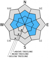
Overall, MODERATE avalanche danger exists near and below treeline all aspects slopes 37 degrees and steeper. CONSIDERABLE danger exists above treeline for continued wind slab formation mainly on leeward NE-E-SE aspects slopes 35 degrees and steeper. Remaining storm slabs may exist above treeline 9,000 feet and up all aspects. Size and distribution of wind slabs and their sensitivity to trigger is uncertain. Human trigger of wind slabs remains possible. Evaluate the snowpack, identify features of concern, use conservative decision making.


Avalanche Problem 1: Wind Slab
-
Character ?

-
Aspect/Elevation ?
-
Likelihood ?CertainVery LikelyLikelyPossible
 Unlikely
 -
Size ?HistoricVery LargeLargeSmall

Stiff wind slabs will be our main avalanche problem of concern today near and above treeline. Natural avalanche activity was observed on SSE to ESE aspects at 9,800 feet and above along Casaval and Sargent's Ridge. Remaining wind slab distribution and sensitivity to human trigger is uncertain due to lack of observation of the snowpack at higher elevations. Decent visibility above treeline this morning may entice backcountry travelers to venture further up above treeline on Mt. Shasta. Caution should be taken in choosing your route of travel. Avoid exposure to terrain traps with suspect leeward slopes above. SE-E-NE slopes 35 degrees and steeper will be the most likely aspects to find wind slabs, but cross loading may have developed slabs on W-NW-N aspects as well.
Avalanche Problem 2: Storm Slab
-
Character ?

-
Aspect/Elevation ?
-
Likelihood ?CertainVery LikelyLikelyPossible
Unlikely
-
Size ?HistoricVery LargeLargeSmall
Soft storm slabs may remain, but will be more likely to be encountered on northerly aspects. The sun had a noticeable impact on the snow yesterday on southerly aspects creating a melt/sun crust that froze overnight. That may make things interesting for backcountry travelers today. Natural trigger of any remaining soft storm slabs will be unlikely. Human trigger may be possible if just the right trigger point is found on slopes 37 degrees and steeper. The potential for loose dry snow instabilities will remain a possibility, as well, on northerly shaded aspect, slopes 37 degrees and steeper. They will be small in size, but may entrain enough snow to be a hazard to backcountry travelers in just the right set of circumstances. They could push you into undesirable terrain such as into rocks or trees, or over a cliff band. Use caution when choosing your line today.
Forecast Discussion
Good Morning! In Mt Shasta City at 0500, we have a current temperature of 34 F, three degrees cooler than yesterday at this time. Skies are overcast with calm wind.
On Mt Shasta (South Side) in the last 24 hours...
Old Ski Bowl - 7,600 feet, the current temperature is 18 degrees F. Snow on the ground totals 137 inches with 18 inches of new snow and little settlement. Temperatures have ranged from 18 F to 23 F.
Gray Butte - 8,000 feet, the current temperature is 18 degrees F. Temperatures have ranged from 17 F to 23 F. Winds have averaged 10-15 mph west/northwest in direction, shifting to southwest after 900, with a max gust to 21 mph, west/northwest. The anemometer at the Gray Butte weather station appears to have rimed up and has stopped working at about 2 am this morning. We will monitor, but expect it to melt and start functioning as soon as temperatures rise.
Mt Eddy Range (West side of Interstate-5)...
Castle Lake - 5,600 feet, the current temperature is 25 degrees. Temperatures have ranged from 24 F to 35 F. Snow on the ground totals 69 inches with 13 inches of new snow and no settlement.
Mt Eddy - 6,500 feet, the current temperature is 23 degrees F. Temperatures have ranged from 21 F to 30 F. Snow on the ground measures 82 inches with 10 inches of new snow and 1 inch of settlement. Winds have averaged 2 mph with a max gust of 13 mph, southwest. The anemometer was functioning again by 11 am yesterday morning.
Always check the weather before you attempt to climb Mt Shasta. Further, monitor the weather as you climb. Becoming caught on the mountain in any type of weather can compromise life and limb. Be prepared.
Recent Observations
Observations with Weather Synopsis below:
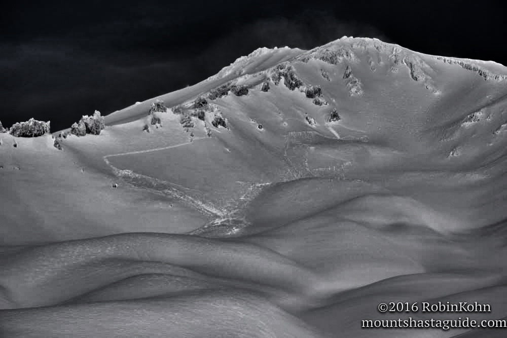
Yesterday's weather favored those who made it out in the backcountry early. Light and dry powder conditions greeted those who favor the dawn patrol approach. As the day progressed the clouds began to dissipate, and by mid afternoon mostly sunny skies prevailed. The sun had a profound impact on southerly aspects settling the new snow several inches near treeline and created a melt/sun crust an inch thick in places. Reports from a backcountry skier who toured to just above treeline yesterday afternoon in the Avalanche Gulch vicinity reported less than desirable conditions due to solar gain affecting the snow. On more northerly, shaded aspects the snow was wind affected but soft with 4 finger to fist density. Stability tests did not reveal much as the soft snow simply colapsed under stress with no clear shearing or failure. A very large naturally triggered avalanche occurred at the tail end of Sunday's storm on the SSE aspect of Casaval Ridge (see photo) stretching from above the foot of 50/50 flat to near "Madonna's Spire" above Helen Lake. The crown was estimated to be 1-2 ft thick. Evidence of a crown on a similar ESE aspect of Sargent's Ridge emptying into Mud Creek Glacier cirque was observed as well.
For today, the main concern will be for stiff wind slabs above treeline, mainly on leeward SE-E-NE aspects. Some soft storm slab instabilities may be found at higher elevations (9,500 feet and up). The distribution of wind slabs and their sensitivity to trigger is uncertain due to lack of observations in above treeline areas at higher altitudes. Simply considering the fact that 16-18 inches of snow fell is such a short time frame with Sunday's storm, lingering sensitivities may still exist today. Continue to use caution when choosing your route of travel, especially if considering going above treeline. Loose dry sloughs may still be encountered on northerly shaded aspects on slopes 37 degrees and steeper. Evaluate the snowpack, travel one at a time when crossing steeper slopes and known avalanche paths or run out zones, identify any features of concern and avoid them, and use conservative decision making. Good group communication is essential.
Very large naturally triggered wind/storm slab avalanche on SSE aspect of Casaval Ridge depositing into Climbers's Gully, Avalanche Gulch 3/7/2016-photo: Robin Kohn:
Weather Synopsis:
A weak cold front will move across our area with light precipitation beginning to fall around mid day. Winds will increase with the coming front reaching speeds of 30-40 mph near and above treeline. As this system dissipates a warm front will follow on Wednesday with more precipitation and rising snow levels. For today's storm, expect snow levels of around 5,500 feet. They will rise to 6,500-7,500 feet on Wednesday then begin to drop on Friday into the weekend. The second half of this week looks to be fairly wet with total water amounts reaching 3+ inches.
-----------------------------------------------------------------------------------------------------------------------------------------------------------
LOCAL AREA ROAD, NORDIC, AND SNOWMOBILE PARK STATUS:
The Sand Flat cross country ski trails are in good shape and ready for your cross country skis and snow shoes. These are backcountry routes marked with blue diamonds on trees. Trails are not groomed. Snow shoers, please blaze a parallel trail to cross country skiers staying out of the skin track. These trails can be accessed via the Everett Memorial Highway. Thank you, and enjoy!
The Mt. Shasta Nordic Center is open! These beautiful, groomed trails can be accessed via the Ski Park Highway. http://www.mtshastanordic.org
The Pilgrim Creek & Deer Mountain Snowmobile Parks are open! Trails have not been groomed in the past week and a half due to warm temperatures. Head to our "Education" tab on our website and find the snowmobile section for trail information, grooming status, and other sledder resources.
The Castle Lake Road is plowed to the lake. The Everett Memorial Highway is plowed to Bunny Flat.
The Five Red Flags of Avalanche Danger any time of year include: 1) Recent/current avalanche activity 2) Whumphing sounds or shooting cracks 3) Recent/current heavy snowfall 4) Strong winds transporting snow 5) Rapid warming or rain on snow.
Weather and Current Conditions
Weather Summary
Good Morning! In Mt Shasta City at 0500, we have a current temperature of 28 F, six degrees cooler than yesterday at this time. Skies are partly cloudy with calm wind.
On Mt Shasta (South Side) in the last 24 hours...
Old Ski Bowl - 7,600 feet, the current temperature is 15 degrees F. Snow on the ground totals 129 inches with no new snow and 8 inches of settlement! Temperatures have ranged from 14 F to 33 F.
Gray Butte - 8,000 feet, the current temperature is 19 degrees F. Temperatures have ranged from 15 F to 32 F. Winds have averaged 0-5 mph until midnight then increasing to 10-15 mph easterly in direction with a max gust to 28 mph, east. The anemometer at the Gray Butte weather station started functioning again yesterday at 4 pm with some sun exposure and warming temps.
Mt Eddy Range (West side of Interstate-5)...
Castle Lake - 5,600 feet, the current temperature is 24 degrees. Temperatures have ranged from 21 F to 31 F. Snow on the ground totals 67 inches with no new snow and 2 inches of settlement.
Mt Eddy - 6,500 feet, the current temperature is 16 degrees F. Temperatures have ranged from 13 F to 26 F. Snow on the ground measures 81 inches with no new snow and 1 inch of settlement. Winds have averaged 2 mph with a max gust of 14 mph, south/southeast.
Always check the weather before you attempt to climb Mt Shasta. Further, monitor the weather as you climb. Becoming caught on the mountain in any type of weather can compromise life and limb. Be prepared.
| 0600 temperature: | 13 |
| Max. temperature in the last 24 hours: | 32 |
| Average wind direction during the last 24 hours: | Easterly |
| Average wind speed during the last 24 hours: | 0-5 mph until midnight increasing to 10-15 mi/hr |
| Maximum wind gust in the last 24 hours: | 28 (Gray Butte) mi/hr |
| New snowfall in the last 24 hours: | 0 inches |
| Total snow depth: | 91 inches |
Two Day Mountain Weather Forecast
Produced in partnership with the Medford NWS
| For 7000 ft to 9000 ft | |||
|---|---|---|---|
|
Tuesday (4 a.m. to 10 p.m.) |
Tuesday Night (10 p.m. to 4 a.m.) |
Wednesday (4 a.m. to 10 p.m.) |
|
| Weather | Partly cloudy this morning then mostly cloudy with a 70% chance of snow in the afternoon. Breezy | Cloudy with 100% chance of snow. | Cloudy with 100% chance of snow in the morning, then rain and snow. in the afternoon. |
| Temperature (°F) | 34 | 25 | 40 |
| Wind (mi/hr) | Northeast becoming south/southwest late morning 10-15 mph with gusts to around 40 mph | South 10-15 mph with gusts to 25 | South 15-20 mph |
| Precipitation SWE / Snowfall (in) | / 0-1 | / 1-3 | / 0-1 |
| For 9000 ft to 11000 ft | |||
| Tuesday | Tuesday Night | Wednesday | |
| Weather | Partly cloudy this morning then mostly cloudy with a 70% chance of snow this afternoon. Windy with wind chill values as low as -10 | Cloudy with a 100% chance of snow. Windy with wind chill values as low as -5 | Cloudy with 100% chance of snow. Windy with wind chill values as low as -3 |
| Temperature (°F) | 20 | 20 | 23 |
| Wind (mi/hr) | West 25-30 mph with gusts to around 50 mph | West 1-3 | West 45-55 mph with higher gusts |
| Precipitation SWE / Snowfall (in) | / 1-3 | / 3-5 | / 3-5 |

