

You are here
Avalanche Advisory for 2016-03-09 06:59:36
- EXPIRED ON March 10, 2016 @ 6:59 amPublished on March 9, 2016 @ 6:59 am
- Issued by Nick Meyers - Shasta-Trinity National Forest
Bottom Line
Below treeline, the avalanche danger is LOW. Near and above treeline, MODERATE danger continues for wind slab instabilities. Remaining weaknesses could linger on NE-E-SE slopes. New, small wind slabs are also possible on similar aspects due to new snow and southerly winds forecast for today. Depending how rapid of onset the new snow, CONSIDERABLE avalanche danger is possible late in the day. Slopes steeper than 37 degrees should be of highest concern.


Avalanche Problem 1: Wind Slab
-
Character ?

-
Aspect/Elevation ?

-
Likelihood ?CertainVery LikelyLikelyPossible
 Unlikely
 -
Size ?HistoricVery LargeLargeSmall

Wind slabs will be our main avalanche problem of concern today near and above treeline. Natural avalanche activity was observed on SSE to ESE aspects at 9,800 feet and above along Casaval and Sargent's Ridge two days ago. Remaining wind slabs remains possible at higher elevations. Avoid exposure to terrain traps with suspect leeward slopes above. SE-E-NE slopes 37 degrees and steeper will be the most likely aspects to find wind slabs, but cross loading may have developed slabs on W-NW-N aspects as well. New wind slabs may form today due to new snow and southerly wind increasing throughout the day.
Recent Observations
We saw widespread settlement in the snowpack since our 18 inch snowstorm from two days ago. Eight inches of settlement was recorded at the Old Ski Bowl station. Still the only reported slides that came in were the Casaval/Avalanche Gulch slide (pictured below) and the east side (Mud Creek area) crown viewed from the top of Gray Butte. It's likely that most of the avalanche danger resulting from our most recent storm has subsided given we've had two days of decent sun on the snowpack.
Southerly aspects got impacted heavily when the sun was out the past few days. A several inch zipper crust exists on most sunny aspects currently. Soft snow was reported in the protected trees on shadier aspects. Above treeline, observations have been limited. Ridgelines certainly look wind affected. We've had a mix of winds the past few days blowing from many directions.
I would suspect that east/southeast facing slopes above treeline will continue to be most suspect. These slopes will be the same aspect as the two slides observed from a two days ago. Remaining wind/storm slabs are possible. New wind slabs are certain with the incoming storm and accompanied wind out of the south/southwest.
Discussion from 3-8-16:
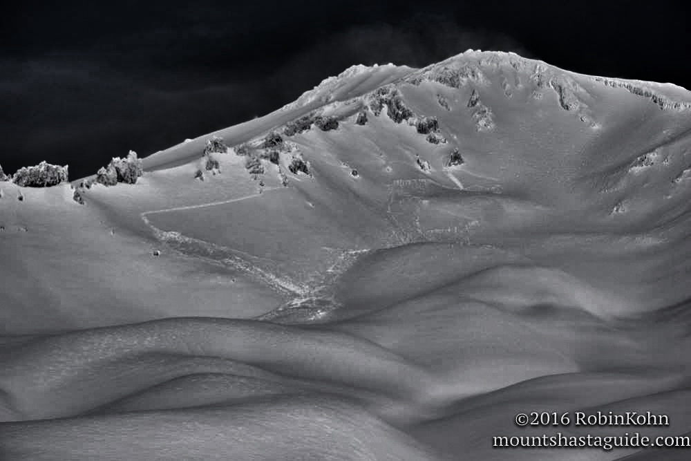
Yesterday's (3-7-16) weather favored those who made it out in the backcountry early with light and dry powder. As the day progressed the clouds began to dissipate, and by mid afternoon mostly sunny skies prevailed. The sun had a profound impact on southerly aspects settling the new snow several inches near treeline and created a melt/sun crust an inch thick in places. Reports from a backcountry skier who toured to just above treeline yesterday afternoon in the Avalanche Gulch vicinity reported less than desirable conditions due to solar gain affecting the snow. On more northerly, shaded aspects the snow was wind affected but soft with 4 finger to fist density. Stability tests did not reveal much as the soft snow simply colapsed under stress with no clear shearing or failure. A large naturally triggered avalanche occurred at the tail end of Sunday's storm on the SSE aspect of Casaval Ridge (see photo) stretching from above the foot of 50/50 flat to near "Madonna's Spire" above Helen Lake. The crown was estimated to be 1-2 ft thick. Evidence of a crown on a similar ESE aspect of Sargent's Ridge emptying into Mud Creek Glacier cirque was observed as well.
Large naturally triggered wind/storm slab avalanche on SSE aspect of Casaval Ridge depositing into Climbers's Gully, Avalanche Gulch 3/7/2016
-----------------------------------------------------------------------------------------------------------------------------------------------------------
LOCAL AREA ROAD, NORDIC, AND SNOWMOBILE PARK STATUS:
The Sand Flat cross country ski trails are in good shape and ready for your cross country skis and snow shoes. These are backcountry routes marked with blue diamonds on trees. Trails are not groomed. Snow shoers, please blaze a parallel trail to cross country skiers staying out of the skin track. These trails can be accessed via the Everett Memorial Highway. Thank you, and enjoy!
The Mt. Shasta Nordic Center is open! These beautiful, groomed trails can be accessed via the Ski Park Highway. http://www.mtshastanordic.org
The Pilgrim Creek & Deer Mountain Snowmobile Parks are open! Trails have not been groomed in the past week and a half due to warm temperatures. Head to our "Education" tab on our website and find the snowmobile section for trail information, grooming status, and other sledder resources.
The Castle Lake Road is CLOSED at the gate. The culvert blew out and we do not know when it will be repaired. The Everett Memorial Highway is plowed to Bunny Flat.
The Five Red Flags of Avalanche Danger any time of year include: 1) Recent/current avalanche activity 2) Whumphing sounds or shooting cracks 3) Recent/current heavy snowfall 4) Strong winds transporting snow 5) Rapid warming or rain on snow.
Weather and Current Conditions
Weather Summary
Good Morning! In Mt Shasta City at 0500, we have a current temperature of 36 F, six degrees warmer than yesterday at this time. Skies are obscured with light snow falling.
On Mt Shasta (South Side) in the last 24 hours...
Old Ski Bowl - 7,600 feet, the current temperature is 23 degrees F. Snow on the ground totals 132 inches with 3 inches new snow and little settlement. Temperatures have ranged from 17 F to 26 F.
Gray Butte - 8,000 feet, the current temperature is 22 degrees F. Temperatures have ranged from 18 F to 23 F. Winds have averaged 10 mph, westerly in nature with gusts to 35 mph out of the northwest.
Mt Eddy Range (West side of Interstate-5)...
Castle Lake - 5,600 feet, the current temperature is 26 degrees. Temperatures have ranged from 24 F to 34 F. Snow on the ground totals 69 inches with 2 inches new snow and little settlement.
Mt Eddy - 6,500 feet, the current temperature is 25 degrees F. Temperatures have ranged from 20 F to 33 F. Snow on the ground measures 81 inches with a trace new snow and little settlement. Winds have averaged 2 mph with a max gust of 9 mph, south/southeast.
Always check the weather before you attempt to climb Mt Shasta. Further, monitor the weather as you climb. Becoming caught on the mountain in any type of weather can compromise life and limb. Be prepared.
WEATHER DISCUSSION:
We've got several storms on tap to entertain us for the remainder of the week. A windy one is upon us now... today expect increasing southerly winds with light to moderate precipitation for most of the day. The storm should kick up considerably tonight with winds increasing as well as precipitation rates. We are looking at about 2 inches of water expected by Friday morning. Cold air is going to struggle to stay in the area. Snow levels will hover around 5,800 feet today, 6,800 feet tonight and 5,500 feet tomorrow. Above treeline wind speeds of 60-70 mph are forecast for tonight and tomorrow with gusts higher. The remainder of the week... we should get a break Thursday night, another front on Friday, a brief break on Friday evening and then a stronger system this weekend on Saturday/Sunday. Needless to say, the next 5 days are going to be wet and windy with snow in the mountains. Keep your heads up for heightened avalanche danger.
THIS SEASON PRECIPITATION for MT SHASTA CITY: Since October 1st (the wet season), we have received 30.29 inches of water, normal is 31.46 inches, putting us at 96% of normal. For the month of March we've received 4.77 inches of water, normal is 1.96 inches, putting us at 243% of normal, and finally... for the year of 2016 we've received 20.80 inches of water, normal is 16.25 inches, putting us at 128% of normal .
| 0600 temperature: | 27 |
| Max. temperature in the last 24 hours: | 27 |
| Average wind direction during the last 24 hours: | Westerly |
| Average wind speed during the last 24 hours: | 10 mi/hr |
| Maximum wind gust in the last 24 hours: | 35 (Gray Butte) mi/hr |
| New snowfall in the last 24 hours: | 1-3 inches |
| Total snow depth: | 91 inches |
Two Day Mountain Weather Forecast
Produced in partnership with the Medford NWS
| For 7000 ft to 9000 ft | |||
|---|---|---|---|
|
Wednesday (4 a.m. to 10 p.m.) |
Wednesday Night (10 p.m. to 4 a.m.) |
Thursday (4 a.m. to 10 p.m.) |
|
| Weather | Snow before 10am, then rain showers. Windy | Rain before 10pm, then rain and snow. Windy. Chance of precipitation is 100%. | Snow before 4pm, then snow showers after 4pm. Breezy. Chance of precipitation is 100%. |
| Temperature (°F) | 39 | 37 | 37 |
| Wind (mi/hr) | South/southeast 10-20 mph | South 10-20 mph | South 10-20 mph |
| Precipitation SWE / Snowfall (in) | / 0-1 | / 3-7 | / 6-10 |
| For 9000 ft to 11000 ft | |||
| Wednesday | Wednesday Night | Thursday | |
| Weather | Snow before 10am, then snow showers between 10am and 4pm, then snow after 4pm. Windy, Chance of precipitation is 100%. | Snow. Windy. Chance of precipitation is 100%. | Snow before 4pm, then snow showers after 4pm. The snow could be heavy at times. Chance of precipitation is 100%. |
| Temperature (°F) | 29 | 21 | 21 |
| Wind (mi/hr) | Southwest 50-60 mph | South/southest 3-5 | South/southwest 40-50 mph |
| Precipitation SWE / Snowfall (in) | / 3-5 | / 5-9 | / 8-12 |

