

You are here
Avalanche Advisory for 2016-03-10 07:13:18
- EXPIRED ON March 11, 2016 @ 7:13 amPublished on March 10, 2016 @ 7:13 am
- Issued by Nick Meyers - Shasta-Trinity National Forest
Bottom Line
As one gains elevation today, the avalanche danger will increase. Southerly winds and upwards of 8 inches of new snow (1.35" h20) fell at treeline over the past 24 hours. CONSIDERABLE danger exists for old and new wind slabs above treeline. At treeline, MODERATE danger will be found for wind and storm slabs. During storms, the avalanche danger may reach periods of HIGH due to rapid snow accumulation paired with wind loading. LOW danger exists below treeline.


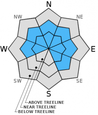
Avalanche Problem 1: Wind Slab
-
Character ?

-
Aspect/Elevation ?
-
Likelihood ?CertainVery LikelyLikelyPossible
 Unlikely
 -
Size ?HistoricVery LargeLargeSmall

Gale force winds have likely transported much of the snow away, far away, off the mountain...but, not all. Wind slabs, new and existing, will be found near and above treeline today. Use caution, conduct stability tests and don't trust them. Lack of above treeline observations leave uncertainty concerning wind slab stability. Unstable wind slabs are likely immediately during or just after snowy/windy periods. If you saw the photo of the Casaval slide from a few days ago, that is a classic example. If you didn't see it, log on to our Facebook page. Cross loading of slopes and mid-slope wind loaded areas are more common during extreme wind events, like we just experienced this past 12 hours.
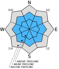
Avalanche Problem 2: Storm Slab
-
Character ?

-
Aspect/Elevation ?
-
Likelihood ?CertainVery LikelyLikelyPossible
Unlikely
-
Size ?HistoricVery LargeLargeSmall
New heavy, wet snow on top of lighter density snow (just below March 7 crust) could create storm slab release. Up to a foot of new snow sits on top of the March 7th crust with lighter density snow below the delicate layer. Conduct stability tests, dig hand pits to identify where heavier snow may sit on top of lighter snow.
Recent Observations
Despite mist, fog and very poor visibility yesterday, I traveled up into treeline areas on the south side of Mt Shasta for a look at the snowpack. With the recent new snow, sun, rain and mixed weather we've had over the past three days, I figured there might be a few layers of concern...especially given the looming forecast for additional FEET of snow. I am a little uncertain how exactly the current snowpack will accept the ample amounts of new snow over the remainder of the week, but my gut feeling is that we will see some avalanche activity. That said, we've had three days for the snow to settle out. Upwards of 8-10 inches of settlement occured in some areas and the only avalanches we observed or have been reported are the Casaval and East side slides, both SE facing slopes at similar elevations, occuring late on 3-6 or early on 3-7. Above treeline is still uncertain from lack of snowpit data. My biggest concern is not so much the current snowpack as it stands, but ample amounts of NEW snow ON TOP of our current snowpack in the coming days.
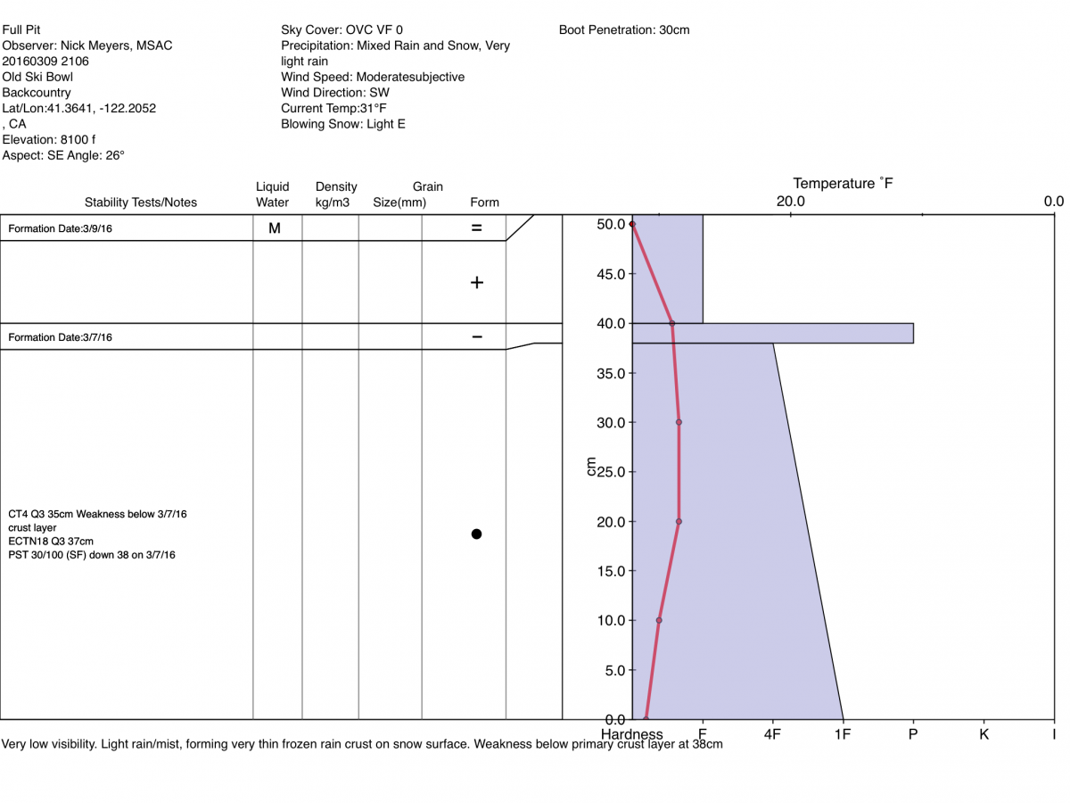
The current snowpack, above the hard, old snow, consists of approximately 50-55cm new snow near treeline. Most of that fell over the course of 15 hours this past Sunday/Monday (3-6 and 3-7). It was mid to late in the day on Monday the 7th that our temperature/sun crust formed and froze, creating a 1-2cm pencil hardness zipper crust. This crust lies about 10-15 cm deep in the snowpack. The crust distribution is fairly widespread and can be easily felt with hand pits, though in some areas immediately adjacent, the crust was absent. This was in part due to shading from trees and/or a shadier aspects. Northerly aspects, the crust is absent. On top of the crust, 10cm of snow fell most recently early in the week and another few inches on top of that from the last 24 hours. Late yesterday, despite an air temperature of 31 degrees, a light mist/rain was present at 8,100 feet and was creating a very thin rain crust on the immediate surface of the snowpack. So...that is the current set-up.
Stability test wise, weaknesses were consistent directly below the March 7th sun crust, but propagation was poor. [ ECTN18@37cm - Q3 / CT4@35cm - Q3 / PST30/100(SF) down 13cm ] Lighter density snow exists below the March 7th crust and this was the failing layer with all tests. It is my concern that rapid onset of heavy precipitation, high precip rates including rain on snow, additional wind loading...all these factors on top of this snowpack could create small to large slides in the coming days. Additionally, the thin rain crust of mention on the surface of the snowpack could create a suttle enough bed surface for another potential weak layer.
Above treeline observations have been limited due to visibility. We got a good look at the southeast facing slide off Casaval Ridge and the East side on Monday. Remaining and also NEW wind slabs above treeline are certainly a possibility today and for the rest of the week. Below treeline, rain on snow yesterday helped squish the snowpack and avalanche concerns are minimal, again below treeline.
Today, wind loaded slopes above treeline will be the biggest concern. Existing wind slabs will continue to build in size with steady precipitation expected today. Southerly winds will load NW-N-NE-E-SE slopes. Changes in temperature and snow levels will create different density snow layering. It's often that these density changes act as the weak layer. Your 'A" game is going to be necessary and it might just be a good idea to stay off avalanche terrain entirely. Periods of HIGH avalanche danger are likely immediately during or just after these storms.
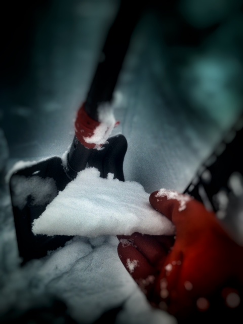
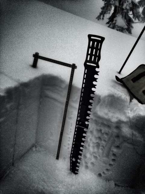
Left - March 7th crust, 1-2cm thick sitting 10-15cm deep in the snowpack, now deeper due to 8 inches new snow within the last 24 hours. Right - New snow since Sunday the 6th.
-----------------------------------------------------------------------------------------------------------------------------------------------------------
LOCAL AREA ROAD, NORDIC, AND SNOWMOBILE PARK STATUS:
The Sand Flat cross country ski trails are in good shape and ready for your cross country skis and snow shoes. These are backcountry routes marked with blue diamonds on trees. Trails are not groomed. Snow shoers, please blaze a parallel trail to cross country skiers staying out of the skin track. These trails can be accessed via the Everett Memorial Highway. Thank you, and enjoy!
The Mt. Shasta Nordic Center is open! These beautiful, groomed trails can be accessed via the Ski Park Highway. http://www.mtshastanordic.org
The Pilgrim Creek & Deer Mountain Snowmobile Parks are open! Trails have not been groomed in the past week and a half due to warm temperatures. Head to our "Education" tab on our website and find the snowmobile section for trail information, grooming status, and other sledder resources.
The Castle Lake Road is CLOSED at the gate. The culvert blew out and we do not know when it will be repaired. The Everett Memorial Highway is plowed to Bunny Flat.
The Five Red Flags of Avalanche Danger any time of year include: 1) Recent/current avalanche activity 2) Whumphing sounds or shooting cracks 3) Recent/current heavy snowfall 4) Strong winds transporting snow 5) Rapid warming or rain on snow.
Weather and Current Conditions
Weather Summary
Good Morning! In Mt Shasta City at 0500, we have a current temperature of 43 F, seven degrees warmer than yesterday at this time. Skies are obscured with rain falling, heavy at times and windy.
On Mt Shasta (South Side) in the last 24 hours...
Old Ski Bowl - 7,600 feet, the current temperature is 29 degrees F. Snow on the ground totals 138 inches with 4-6 inches new snow and little settlement. Temperatures have ranged from 26 F to 31 F.
Gray Butte - 8,000 feet, the current temperature is 28 degrees F. Temperatures have ranged from 24 F to 30 F. Winds have been southerly in nature. Wind speeds are inaccurate this morning due to riming on the anemometer. It seems the heaters for the instruments have quit working. We are addressing the issue. It is quite likely that the winds have been much stronger than reported from the station.
Mt Eddy Range (West side of Interstate-5)...
Castle Lake - 5,600 feet, the current temperature is 33 degrees. Temperatures have ranged from 26 F to 35 F. Snow on the ground totals 67 inches with no new snow and 2 inches settlement due to rain on snow.
Mt Eddy - 6,500 feet, the current temperature is 31 degrees F. Temperatures have ranged from 24 F to 34 F. Snow on the ground measures 78 inches with a 2-4 inches new snow and 2 inches settlement due to rain on snow at times. Winds have averaged 4 mph with a max gust of 21 mph, south/southeast.
Always check the weather before you attempt to climb Mt Shasta. Further, monitor the weather as you climb. Becoming caught on the mountain in any type of weather can compromise life and limb. Be prepared.
WEATHER DISCUSSION:
We are looking at FIVE storms to impact the forecast area from now through Sunday, and it looks like this: Today, lingering strong winds and continued moderate showers will be the main impact from this first storm. Next, a storm on Friday that will mainly impact Southern Siskiyou County and south across California. A third strong cold front will be focused on our area Saturday. The fourth on Sunday, stronger and wetter than models originally suggested and lastly, a surface trough on Monday with light to moderate precipitation focused mainly on the West side but also lowering snow levels. Sheesh! I might need to start a tally to keep track of all these storms. Today, west side areas will see the storm grip loosen a bit, however the Mt Shasta area will get upwards of an inch of water. Snow levels are going to stay near 6,000 feet today, perhaps slightly higher. We will get a short "break" in the action late today/tonight, but quick to pick back up on Friday with a cold front, helping lower snow levels down to 5,500 feet. From now through Saturday morning, we're looking at near 2.5 inches of water. Winds should lighten up, but never cease throughout the rest of the week.
THIS SEASON PRECIPITATION for MT SHASTA CITY: Since October 1st (the wet season), we have received 30.76 inches of water, normal is 31.69 inches, putting us at 97% of normal. For the month of March we've received 5.24 inches of water, normal is 2.19 inches, putting us at 239% of normal, and finally... for the year of 2016 we've received 21.27 inches of water, normal is 16.48 inches, putting us at 129% of normal .
| 0600 temperature: | 27 |
| Max. temperature in the last 24 hours: | 27 |
| Average wind direction during the last 24 hours: | Westerly |
| Average wind speed during the last 24 hours: | 10 mi/hr |
| Maximum wind gust in the last 24 hours: | 35 (Gray Butte) mi/hr |
| New snowfall in the last 24 hours: | 1-3 inches |
| Total snow depth: | 91 inches |
Two Day Mountain Weather Forecast
Produced in partnership with the Medford NWS
| For 7000 ft to 9000 ft | |||
|---|---|---|---|
|
Thursday (4 a.m. to 10 p.m.) |
Thursday Night (10 p.m. to 4 a.m.) |
Friday (4 a.m. to 10 p.m.) |
|
| Weather | Snow before 10am, then snow showers after 10am. High near 38. Breezy, with a south wind 20 to 25 mph, with gusts as high as 40 mph. Chance of precipitation is 100%. Total daytime snow accumulation of 2 to 4 inches possible. | Snow showers before 10pm, then snow after 10pm. Low around 31. Breezy, with a south southeast wind 10 to 20 mph, with gusts as high as 30 mph. Chance of precipitation is 100%. New snow accumulation of 8 to 12 inches possible. | Snow. High near 36. Breezy, with a south wind 10 to 20 mph, with gusts as high as 40 mph. Chance of precipitation is 100%. New snow accumulation of 6 to 10 inches possible. |
| Temperature (°F) | 38 | 31 | 36 |
| Wind (mi/hr) | South 20-25 | South/southeast 10-20 mph | South 10-20 mph |
| Precipitation SWE / Snowfall (in) | / 2-4 | / 8-12 | / 6-10 |
| For 9000 ft to 11000 ft | |||
| Thursday | Thursday Night | Friday | |
| Weather | Snow before 10am, then snow showers after 10am. The snow could be heavy at times. Temperature falling to around 20 by 5pm. Wind chill values as low as -4. Windy, with a south southwest wind 45 to 50 mph decreasing. Winds could gust as high as 115 mph in exposed areas. Chance of precipitation is 100%. Total daytime snow accumulation of 10 to 14 inches possible. | Snow showers before 10pm, then snow after 10pm. The snow could be heavy at times. Low around 18. Wind chill values as low as -6. Windy, with a south wind 40 to 45 mph, with gusts as high as 80 mph in exposed areas. Chance of precipitation is 100%. New snow accumulation of 10 to 14 inches possible. | Snow. The snow could be heavy at times. High near 23. Wind chill values as low as -2. Windy, with a south wind 35 to 40 mph decreasing in the morning. Winds could gust as high as 85 mph in exposed areas. Chance of precipitation is 100%. New snow accumulation of 9 to 13 inches possible. |
| Temperature (°F) | 20 | 18 | 23 |
| Wind (mi/hr) | South/Southwest 45-50 | South 10-14 | South 35-40 |
| Precipitation SWE / Snowfall (in) | / 10-14 | / 10-14 | / 9-13 |

