

You are here
Avalanche Advisory for 2016-04-13 06:29:05
- EXPIRED ON April 14, 2016 @ 6:29 amPublished on April 13, 2016 @ 6:29 am
- Issued by Nick Meyers - Shasta-Trinity National Forest
Bottom Line
Overall, LOW avalanche danger exists for all elevations and aspects today.
A winter storm advisory is in effect for later today, tonight and tomorrow. Increasing southwest winds (40-50 mph above treeline) with 5-10 inches of new snow is expected over the next 48 hours. New wind and storm slabs are certain and the avalanche danger will rise as new snow accumulates on top of our firm, melt/freeze snowpack.


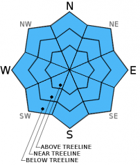
Avalanche Problem 1: Normal Caution
-
Character ?

-
Aspect/Elevation ?
-
Likelihood ?CertainVery LikelyLikelyPossible
 Unlikely
 -
Size ?HistoricVery LargeLargeSmall

Today is the calm before the storm. We are going to see some scattered showers here and there with cooling temperatures, however the brunt of the storm will arrive tonight and tomorrow. A decent re-freeze last night will keep loose wet slides in the bag and until new snow begins to fall, wind and storm slabs will not be an issue. Tomorrow and Friday are our biggest concerns for avalanche activity. Normal caution is advised today and LOW avalanche danger will prevail for all aspects and elevations. The danger will rise, potentially as early as late this afternoon, but most likely tomorrow.
Pay attention to the weather as you recreate on Mt Shasta. This time of year it can change drastically and we're going to see a good example of that over the next several days. In regards to the potential of lightening... the bottom line is, Mt Shasta is a 14,000 foot lightening rod. Do not climb into a white-out and/or electrical activity! It's never a good idea, period.
Forecast Discussion
We are on track for a significant change in the weather today and into Thursday evening with mountain snowfall with wet and windy conditions, mainly on Thursday. Isolated showers this morning and some this afternoon are possible. Most notable will be the increasing southwest winds. Speeds of 40-50 mph with gusts higher in exposed terrain are likely. Rain with a cold front will arrive this eveing. Snow levels will drop from about 6,000 feet down to 3,500 to 4,000 feet by Thursday morning. Crater Lake is expected to receive some decent snowfall, Mt Shasta will be slightly less. Snowfall is predicted to be the most over western Siskiyou County. Cooling behind the storm will be drastic with highs on Thursday about a dozen degrees below normal. Widespread showers Thursday will taper Friday. An abrubt warming trend from incoming high pressure will take place from Friday to early next week. In fact, the possibility of a morning freeze on Saturday could be followed by record highs on Monday. Classic spring weather! This is exactly what we mean when we tell climbers to be prepared for any type of weather this time of year! Snow, wind, rain, cold, and/or hot!
THIS SEASON PRECIPITATION for MT SHASTA CITY: Since October 1st (the wet season), we have received 37.55 inches of water, normal is 36.77 inches, putting us at 102% of normal. For the month of April we've received 0.82 inches of water, normal is 1.31 inches, putting us at 62% of normal, and finally... for the year of 2016 we've received 28.06 inches of water, normal is 21.56 inches, putting us at 130% of normal.
Recent Observations
The cooling trend mentioned yesterday is happening... temps are already 10-15 degrees cooler than yesterday. About .5 inches of water fell yesterday, mostly in the AM hours and with a brief shot in the afternoon. Snow levels were high, so mostly rain on snow occurred except for the upper mountain that likely received a shallow coating. Lightening storms were visible to the south of Mt Shasta in the evening, but nothing locally.
Significant instability has not been observed in the forecast area. Small loose wet slides off the southeast aspect of Casaval Ridge, below 10,000 feet, have been noted over the week, but nothing large enough to bury a person. One loose wet made it down into Climbers Gully, but still didn't host enought snow to cause concern for backcountry travelers. With the temperatures falling below freezing last night and further cooling today and tomorrow, loose wet slides will not be a concern. Some rain on snow has put even a further dampener on the chance of loose wet activity. Snow levels have been about 9 to 10,000 feet for much of the week. Some high elevation snow has occurred, but it has not accumulated enough to prompt concern for new wind and/or storm slab avalanches.
That said, we've got snow levels dropping over the next 48 hours with 5 to 10 inches of snow possible. That IS enough snow, accompanied by moderate to high southwest winds, to cause concern for climbers and skiers this weekend. WIth some fresh snow on the mountain and the skies turning blue on Friday, backcountry users are going to need to be aware of the hazards of this scenario. New wind slabs will be the primary concern. Be sure to check the avalanche advisory before you head up onto the mountain this weekend. Pay attention to mother natures signs of instability. Recent avalanche activity is one of the best signs that avalanches are possible. If you plan on climbing this weekend, a beacon, shovel and probe are highly recommended. If your a backcountry skier, this might seem like a no brainer. However in the Spring, we see climbers come up all the time sans beacon, shovel and probe. Get the gear, get the training, get the forecast, get the picture and stay out of harms way!
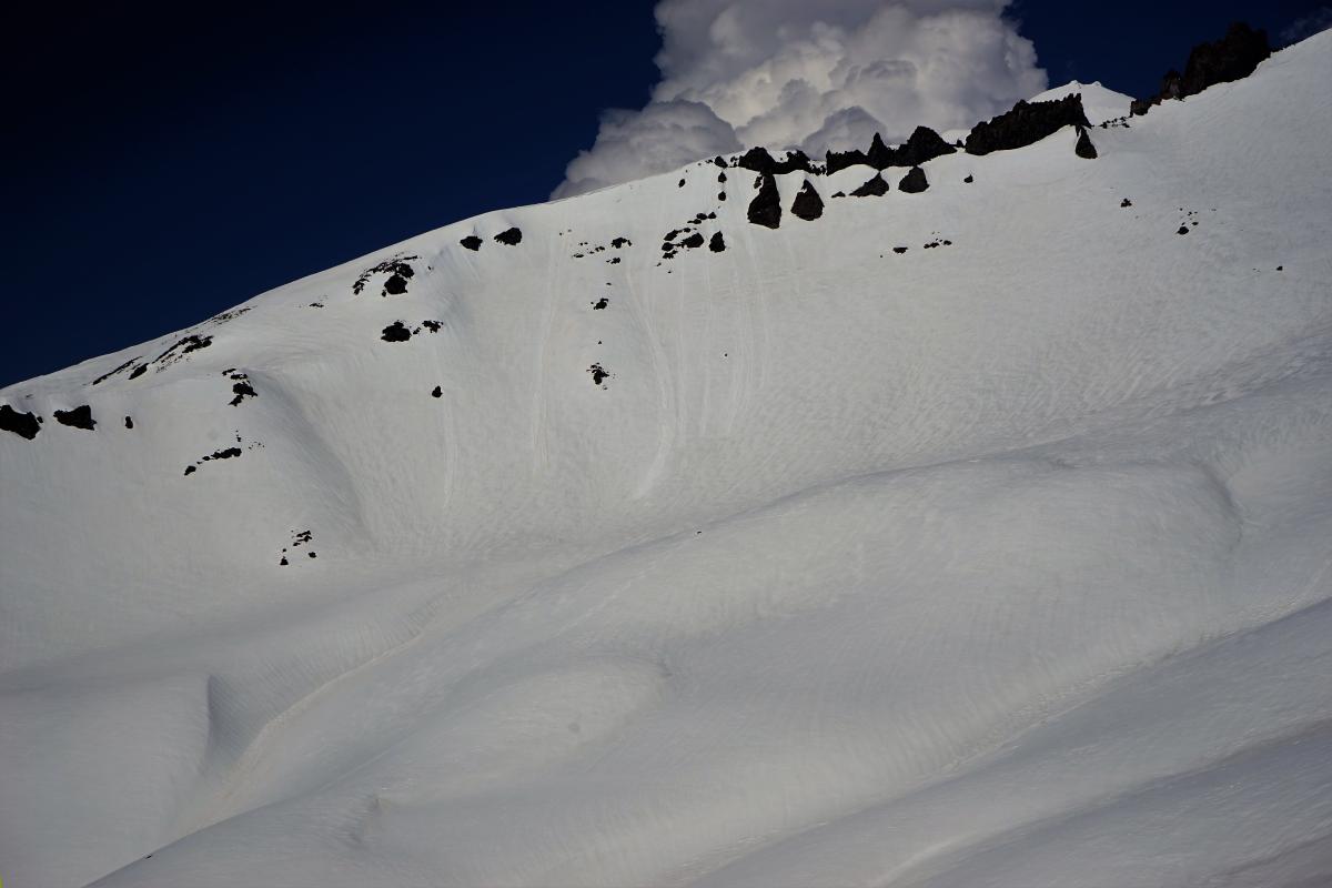
Small loose wet point releases off Casaval Ridge below 10,000 feet - 4.11.16 - Photo: C Carr / Shasta Mtn Guides
Climbing Conditions: Current climbing conditions are good to great. Steadily increasing temperatures this week with overnight lows above freezing will not allow a solid snow re-freeze at night. This could mean post-holing at lower elevations. At higher elevations (11,000 feet and above), however, snow will refreeze better and be firm in the morning hours making crampons (and ice axe) necessary equipment.
Below are some things to think about when planning your trip this Spring:
- Avalanche Danger & Weather: You may encounter a variety of snow conditions during the spring time. Late season storms can bring fresh snow and high winds to the mountains. Avalanche danger can quickly spike due to new wind and storm slabs on top of icy, firm melt/freeze snow. Further, warm and sometimes downright hot days can create loose wet avalanches. Low danger in the cool morning hours may rise rapidly to higher danger during the afternoon hours on sunny aspects. These are two different avalanche problems associated with different weather patterns with both being possible during the same week, or even the same day. A beacon, shovel and probe continue to be essential, even during Spring time. Always check the avalanche advisory before starting your climb, and call the ranger station for the latest in weather and conditions. Spring time weather patterns can bring it all. The point is... you need to bring the appropriate attire to accommodate all weather conditions. Snow, rain, sun, wind... you can count on all of it on Shasta at some point during Spring time. Further, Mt Shasta can often host a cloud cap creating poor visibility conditions. DO NO climb into a white-out. It is very easy to wander off the WRONG side of Mt Shasta when on the upper mountain, >12,500 feet. This can create a long day and perhaps night for climber, party members, rescue resources and family. Play it safe.
- Firm and smooth snow (slide for life conditions): Snow conditions on Mount Shasta are great right now. That being said, the snow in the morning hours is very firm and very smooth. These types of conditions have caused serious injury in the past to those who slip, trip, or fall and fail to self-arrest as they slide. You MUST know how to self-arrest with an ice axe. This is one of your best defenses for a safe trip on Mt Shasta. Practice this and other climbing skills on small, short slopes in soft snow. If you fall, you must immediately self-arrest or you will take a long, sliding, tumbling fall resulting in serious injury or death. Along with your solid ice axe skills, know how to walk/climb with crampons on. It is easy to catch the front points of the crampon on the cuff of your pant leg resulting in a fall if you are not careful with each step.
- Rime Ice: What is rime ice? Rime ice forms on rocks, towers, etc. as super cooled water droplets freeze upon contact with a solid object. The ice grows into the wind taking on a cauliflower like appearance. The exposed rocks on Mt Shasta at higher elevations are currently plastered in rime ice. This hazard will diminish as the ice flakes off on warm days, but until then... HEADS UP! You absolutely should wear a helmet if climbing. As the days warm, chances increase of getting hit by falling ice until all of it falls off.
-----------------------------------------------------------------------------------------------------------------------------------------------------------
LOCAL AREA ROAD, NORDIC, AND SNOWMOBILE PARK STATUS:
The Sand Flat cross country ski trails are in good shape still and ready for your cross country skis and snow shoes. These are backcountry routes marked with blue diamonds on trees. Trails are not groomed. Snow shoers, please blaze a parallel trail to cross country skiers staying out of the skin track. These trails can be accessed via the Everett Memorial Highway. Thank you, and enjoy!
The Mt. Shasta Nordic Center is CLOSED for the season. http://www.mtshastanordic.org
The Pilgrim Creek & Deer Mountain Snowmobile Parks are open, however snow is dwindling fast at these locations. One had to drive down the 19 road (Military Pass) a mile or so to get to consistent snow before unloading just a few days ago. Head to our "Education" tab on our website and find the snowmobile section for trail information, grooming status, and other sledder resources.
The Castle Lake Road is OPEN. The Everett Memorial Highway is OPEN. The Castle Lake and Everett Hwy are plowed year round to the trailheads. The roads are not always first priority, so your dawn patrol powder mission might be ceased if the plow has not made it up yet. Siskiyou County does a great job keeping the roads clear. Be respectful of the plow drivers if you encounter them. If you get to Bunny Flat before or during when the plow is there, please park on the uphill, LEFT side of the parking lot as you drive in. This is uphill and lookers right of the bathrooms. Thank You!
The Five Red Flags of Avalanche Danger any time of year include: 1) Recent/current avalanche activity 2) Whumphing sounds or shooting cracks 3) Recent/current heavy snowfall 4) Strong winds transporting snow 5) Rapid warming or rain on snow.
Weather and Current Conditions
Weather Summary
Good Morning! In Mt Shasta City at 0500, we have a current temperature of 35 F, 15 degrees cooler than yesterday at this time. Skies are obscured with calm wind.
On Mt Shasta (South Side) in the last 24 hours...
Old Ski Bowl - 7,600 feet, the current temperature is 26 degrees F. Snow on the ground totals 126 inches with no new snow and 1 inch of settlement. Temperatures have ranged from 26 F to 40 F.
Gray Butte - 8,000 feet, the current temperature is 24 degrees F. Temperatures have ranged from 24 F to 37 F. Wind speeds are not available for Gray Butte at this time. The anemometer was taken down due to the need for repairs. Thank you for your understanding.
Mt Eddy Range (West side of Interstate-5)...
Castle Lake - 5,600 feet, the current temperature is 30 degrees F. Temperatures have ranged from 30 F to 53 F. Snow on the ground totals 46 inches with no new snow and 2 inches of settlement.
Mt Eddy - 6,500 feet, the current temperature is 27 degrees F. Temperatures have ranged from 27 F to 43 F. Snow on the ground measures 56 inches with no new snow and 1 inch of settlement. Winds have been variable in nature with an average of 1-2 mph, and a maximum gust of 7 mph.
Always check the weather before you attempt to climb Mt Shasta. Further, monitor the weather as you climb. Becoming caught on the mountain in any type of weather can compromise life and limb. Be prepared.
| 0600 temperature: | 28 |
| Max. temperature in the last 24 hours: | 43 |
| Average wind direction during the last 24 hours: | N/A |
| Average wind speed during the last 24 hours: | N/A mi/hr |
| Maximum wind gust in the last 24 hours: | N/A mi/hr |
| New snowfall in the last 24 hours: | 0 inches |
| Total snow depth: | 71 inches |
Two Day Mountain Weather Forecast
Produced in partnership with the Medford NWS
| For 7000 ft to 9000 ft | |||
|---|---|---|---|
|
Wednesday (4 a.m. to 10 p.m.) |
Wednesday Night (10 p.m. to 4 a.m.) |
Thursday (4 a.m. to 10 p.m.) |
|
| Weather | A 20 percent chance of snow showers after 11am. Increasing clouds.. | Snow before 11pm, then snow showers after 11pm. Windy. Chance of precipitation is 90%. | Snow showers. Some thunder is also possible. Breezy. Chance of precipitation is 100%. |
| Temperature (°F) | 41 | 27 | 33 |
| Wind (mi/hr) | Southwest 10-15 mph | South 10-15 mph | South becoming west/southwest in the morning 15-20 mph |
| Precipitation SWE / Snowfall (in) | / 0 | / 2-4 | / 3-5 |
| For 9000 ft to 11000 ft | |||
| Wednesday | Wednesday Night | Thursday | |
| Weather | A 20 percent chance of snow showers after 11am. Increasing clouds. Wind chill values as low as -8. Windy. | Snow before 11pm, then snow showers after 11pm. Wind chill values as low as -18. Windy. Chance of precipitation is 100%. | Snow showers. Some thunder is also possible. Wind chill values as low as -16. Windy. Chance of precipitation is 100%. |
| Temperature (°F) | 19 | 13 | 13 |
| Wind (mi/hr) | Southwest 20-30 mph | Southwest 0 | West 40-50 mph |
| Precipitation SWE / Snowfall (in) | / 0 | / 3-5 | / 3-5 |

