

You are here
Avalanche Advisory for 2017-01-21 07:03
- Issued by Andrew Kiefer - Mt Shasta Avalanche Center
Bottom Line
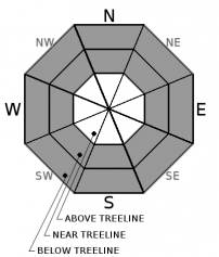
HIGH avalanche danger exists in the backcountry above treeline and near treeline. Below treeline the danger is CONSIDERABLE. Wind slab avalanches are the primary concern, and additional storm slab and cornice problems complicate conditions. Natural avalanches are likely, and human-triggered avalanches are very likely. Snowfall is expected to continue, and the NWS has issued a Winter Storm Warning in effect 4pm this afternoon until 4pm Sunday.


Avalanche Problem 1: Wind Slab
-
Character ?

-
Aspect/Elevation ?

-
Likelihood ?CertainVery LikelyLikelyPossible
 Unlikely
 -
Size ?HistoricVery LargeLargeSmall

Steady, moderate to strong winds have blown for the past 4 days and have created wind slabs on all aspects near and above treeline. Winds have primarily blown from the south, but significant variability has occurred in the redistribution of the new snow throughout the terrain. Avoid traveling on or below steep and wind-loaded slopes. Wind slabs continue to build in size, and the potential for large and destructive wind slab avalanches exists today.
Avalanche Problem 2: Storm Slab
-
Character ?

-
Aspect/Elevation ?
-
Likelihood ?CertainVery LikelyLikelyPossible
Unlikely
-
Size ?HistoricVery LargeLargeSmall
Storm slabs exist on all aspects near and below treeline. Storm slabs may fail within the new snow, or at the old snow/new snow interface. Several small, human-triggered storm slab avalanches occurred yesterday and were 12-16 inches deep. Look for obvious signs of instability like recent avalanches, shooting cracks, and collapsing/whumphing. Avoid slopes steeper than 30 degrees where evidence of an unstable storm slab problem exists.
Avalanche Problem 3: Cornice
-
Character ?

-
Aspect/Elevation ?
-
Likelihood ?CertainVery LikelyLikelyPossible
Unlikely
-
Size ?HistoricVery LargeLargeSmall
Ridgelines within the advisory area hold small to large cornice features, particularly on the west side of I-5 in the Castle Lake and Cliff Lake areas. Rapid snow accumulation and wind transport are adding weight to existing cornices, and building new cornice features. Cornices are often overhung and can break in very unpredictable ways. Be sure to stand back on ridgelines, and avoid traveling on or below steep slopes that are threatened by cornices from above.
Forecast Discussion
Several feet of new snow and strong winds have created a mix of problems, and complex and dangerous avalanche conditions exist in the backcountry. More snow is on the way, and another potent storm is expected to begin by 4pm this afternoon. The avalanche danger will remain elevated, and large avalanches are possible in many areas. Today, respect obvious signs of instability like recent avalanches, shooting cracks, and collapsing/whumphing. Conservative decision-making is essential, and travel in avalanche terrain is not recommended. The Everitt Memorial Highway road status is unknown at this time, and more snow this afternoon and tomorrow will compromise driving conditions.
Recent Observations
Our advisory area has received up to 60” of new snow since the evening of 01/17. Southerly winds have been steady, and temperatures have remained below freezing at all of our remote weather stations for the past 4 days.
Yesterday, multiple storm slab avalanches were human triggered in an area called Eagle’s Flight Cliffs on the boundary of the Mount Shasta Ski Park (See Observations Below). One remotely triggered avalanche occurred as well from about 20ft away while a skier was approaching a steep and unsupported slope. These avalanches occurred on slopes steeper than 35 degrees on southwest aspects at 6500ft. All of these avalanches failed on a density break within new snow - specifically at the interface between Thursday’s storm and Friday’s storm. This interface sits about 12-16 inches below the snow surface.
A rapid load of several inches of water and several feet of new snow has been added to a stable lower snowpack. The new snow appears to be bonding relatively well to the old snow surface, and the primary instabilities lie within the storm snow. Below treeline observations have revealed a reactive storm slab problem, and active wind slab and cornice development continues, and becomes more problematic with elevation gain. So far, observations above treeline have been very limited, but a few quick glimpses into the alpine have revealed significant wind effect, and surprisingly little avalanche activity.
Weather and Current Conditions
Weather Summary
A trough of low pressure will pass through Northern California this morning bringing a chance of light to moderate snowfall for the advisory area. Midday should provide a break in precipitation before it turns back on around 4pm this afternoon. By 10pm tonight, .6 inches of water and 4-8 inches of snow is expected with freezing levels remaining near 3000ft. Moderate southerly winds will continue, and high temperatures for today will reach the low 30’s at the 6000ft elevation.
Another big event arrives later this afternoon and tonight. The National Weather Service has issued a Winter Storm Warning in effect from 4pm this afternoon to 4pm Sunday. A deepening surface low-pressure system sits just offshore of the Oregon Coastline, and will produce southerly and southeasterly flow. This system is looking to be extremely windy, and will provide another dose of heavy precipitation. By Sunday morning, Mount Shasta City could receive an additional foot of heavy snow, while 20-24 inches is expected for areas above 6000ft. Sunday, the snowfall continues, with another 18-20 inches expected by 4pm. Lingering precipitation may last through Monday, and the region should dry out by Tuesday.
===========================================================
In Mt Shasta City at 0500, we have a current temperature of 33 F.
On Mt Shasta (South Side) in the last 24 hours...
Old Ski Bowl - (7,600ft) Not recording data at this time. We are working to get this station up and running again ASAP. Sand Flat (6,750 feet) is recording 5 inches of new snow and 1 inch of settlement in the last 24 hours with a total of 90 inches of snow on the ground.
Grey Butte - 8,000 feet, the current temperature is 17 degrees F. Temperatures have ranged from 17 F to 21 F. Winds have averaged 10-20 mph with gusts to 35 mph, blowing out of the south/southeast and shifting west/southwest.
Mt Eddy Range (West side of Interstate-5)...
Castle Lake - 5,600 feet, the current temperature is 23 degrees F. Temperatures have ranged from 23 F to 29 F. Snow on the ground totals 86 inches with 8 inches of new snow and 2 inches of settlement.
Mt Eddy - 6,500 feet, the current temperature is 20 degrees F. Temperatures have ranged from 20 F to 26 F. Snow on the ground measures 80 inches with 6 inches new snow and 2 inches of settlement. Winds have averaged 1-5 mph with gusts to 17 mph, blowing south/southeast.
THIS SEASON PRECIPITATION for MT SHASTA CITY: Since October 1st (the wet season), we have received 31.11 inches of water, normal is 19.91 inches, putting us at 156% of normal. For the month of January and for the year of 2017, we received 9.95 inches of water, normal is 4.70 inches, putting us at 212% of normal.
Always check the weather before you attempt to climb Mt Shasta. Further, monitor the weather as you climb. Becoming caught on the mountain in any type of weather can compromise life and limb. Be prepared.
| 0600 temperature: | 23 |
| Max. temperature in the last 24 hours: | 27 |
| Average wind direction during the last 24 hours: | South/Southeast |
| Average wind speed during the last 24 hours: | 10-20 mi/hr |
| Maximum wind gust in the last 24 hours: | 35 mi/hr |
| New snowfall in the last 24 hours: | 5 inches |
| Total snow depth: | 90 inches |
Disclaimer

