

You are here
Avalanche Advisory for 2017-04-09 06:32:39
- EXPIRED ON April 10, 2017 @ 6:32 amPublished on April 9, 2017 @ 6:32 am
- Issued by Aaron Beverly - Mount Shasta Avalanche Center
Bottom Line
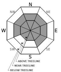
Avalanche danger is MODERATE near and above treeline. MODERATE means natural avalanches are unlikely and human triggered avalanches are possible. Unlikely does not mean impossible so evaluate the snowpack when traveling on or near slopes greater than 35 degrees. Avalanche danger below treeline is LOW.


Avalanche Problem 1: Wind Slab
-
Character ?

-
Aspect/Elevation ?
-
Likelihood ?CertainVery LikelyLikelyPossible
 Unlikely
 -
Size ?HistoricVery LargeLargeSmall

Wind slabs are the primary concern near and above treeline on slopes greater than 35 degrees. The period for natural avalanches has probably passed, but the snowpack could still be sensitive to human trigger. Unsupported slopes, convexities, and slopes below ridgelines are where a wind slab is mostly likely to be triggered. Look for scoured and textured snow surfaces for an indication of where the wind has been blowing and where the leeward aspects are that may be wind loaded.
Forecast Discussion
The snowpack continues to show signs of increasing stability since the storms beginning late Wednesday night brought over 30 inches of new snow. The storm slab problem was short lived and no new signs of this problem have been observed. A natural wind slab avalanche was observed along a north west aspect of Green Butte ridge indicating some instability may still exist within the snow pack near and above treeline. Unusually cold overnight temperatures may have helped preserve these instabilities.
Roller balls were observed yesterday afternoon below treeline as solar radiation warmed up the surface snow. This may indicate a developing wet-loose avalanche problem. Cold temperatures today will likely keep this problem at bay. If you find yourself on steep sun exposed aspects and your boots are penetrating beyond the cuffs into wet snow, you may want to change your route plan to avoid this terrain.
Our last avalanche advisory of the season will be Sunday, April 16th.
Recent Observations
New snow over Friday night totaled 2-3 inches. Westerly winds created isolated wind crusts on easterly aspects. Not much snow remains available for transport and it is mostly confined to gulleys and sheltered areas. No new wind transport was observed. Solar radiation followed by a re-freeze created a breakable crust in sun exposed areas. The best skiing was reported in Avalanche Gulch, though this snow may now be affected by the warming event.
Pit profile on a SW facing aspect of Green Butte Ridge just below treeline shows a right side up snow pack with good bonding within the new snow and at the old snow surface. Moderate resistant planar failures occurred in column tests within the new snow. No propagation was achieved in large column tests.
Height of new snow received since 4/5/17 is 71 cm (28 in). Ski pentetration was 27 cm (10 in) and boot penetration was 64 cm (25 in).
A natural slab avalanche was observed along a northwest facing slope off of Green Butte ridge. This extended about a quarter of a mile with about a 1 foot crown. Run out was short. Ski tracks were seen in Sun Bowl with no signs of avalanche.
Roller balls were seen below treeline along the road cut below Bunny Flat.
Weather and Current Conditions
Weather Summary
Today, expect mostly mostly dry and sunny conditions with increasing cloud cover tonight as a new frontal system moves through. Elevations above 6000' should see below or near freezing temperatures.
The frontal system is expected to bring a short lived storm that could produce a few inches of snow overnight. Snow levels will remain 4000' or lower today and tomorrow.
Monday should be clearer, but more unsettled weather will begin Tuesday and continue through Thursday.
--------------------------------------------------------------------------------
In Mt Shasta City at 0500, we have a current temperature of 29 F
On Mt Shasta (South Side) in the last 24 hours...
Sand Flat - 6,750 ft. The current temperature is 21 degrees F. Temperatures have ranged from 16 F to 31 F. Snow on the ground totals 121 inches with 1 inch of new snow, and 3 inches of settlement.
Old Ski Bowl - 7,600ft. The current temperature is 16 degrees F. Temperatures have ranged from 13 F to 28 F. Snow on the ground totals 205 inches with no new snow and about 4 inches of settlement.
Grey Butte - 8,000 feet. The current temperature is 16 degrees F. Temperatures have ranged from 10 F to 30 F. Winds have averaged 10-15 mph with gusts to 28 mph, blowing mostly from the west and northwest.
Mt Eddy Range (West side of Interstate-5)...
Castle Lake - 5,800 feet. The current temperature is 22 degrees F. Temperatures have ranged from 19 F to 46 F. Snow on the ground totals 111 inches with no new snow and about 3 inches of settlement.
Mt Eddy - 6,500 feet, the current temperature 16 degrees F. Temperatures have ranged from 15 F to 30 F. Snow on the ground measures 105 inches with no new snow and 3 inches of settlement. Winds have averaged 2 mph out of the west southwest with gusts up to 7 mph.
THIS SEASON PRECIPITATION for MT SHASTA CITY: Since October 1st (the wet season), we have received 53.24 inches of water, normal is 36.37 inches, putting us at 146% of normal. For the month of April, we have received 3.78 inches of water, normal is .91 inches, which is 415% of normal. And finally for the year of 2017, we received 32.08 inches of water, normal is 21.16 inches, putting us at 152% of normal.
Always check the weather before you attempt to climb Mt Shasta. Further, monitor the weather as you climb. Becoming caught on the mountain in any type of weather can compromise life and limb. Be prepared.
| 0600 temperature: | 21 |
| Max. temperature in the last 24 hours: | 31 |
| Average wind direction during the last 24 hours: | W, NW |
| Average wind speed during the last 24 hours: | 10-15 mi/hr |
| Maximum wind gust in the last 24 hours: | 28 mi/hr |
| New snowfall in the last 24 hours: | 1 inches |
| Total snow depth: | 121 inches |
Two Day Mountain Weather Forecast
Produced in partnership with the Medford NWS
| For 7000 ft to 9000 ft | |||
|---|---|---|---|
|
Sunday (4 a.m. to 10 p.m.) |
Sunday Night (10 p.m. to 4 a.m.) |
Monday (4 a.m. to 10 p.m.) |
|
| Weather | Mostly sunny. | Snow. Chance of precipitation is 100%. | A 40 percent chance of snow showers, mainly before 11am. Partly sunny. |
| Temperature (°F) | 33 | 22 | 35 |
| Wind (mi/hr) | South 10-15 mph, gusting up to 30 | South 10-20 mph | Southwest 5-10 mph |
| Precipitation SWE / Snowfall (in) | / 0 | / 3-6 | / <1 |
| For 9000 ft to 11000 ft | |||
| Sunday | Sunday Night | Monday | |
| Weather | Mostly sunny. Windy. | Snow. Windy. Chance of precipitation is 100%. | A 40 percent chance of snow showers, mainly before 11am. Partly sunny. Windy. |
| Temperature (°F) | 15 | 11 | 15 |
| Wind (mi/hr) | Southwest 25-30 mph | Southwest 0 | West 14-20 mph |
| Precipitation SWE / Snowfall (in) | / 0 | / 3-7 | / <1 |

