

You are here
Avalanche Advisory for 2017-04-12 06:28:10
- EXPIRED ON April 13, 2017 @ 6:28 amPublished on April 12, 2017 @ 6:28 am
- Issued by Aaron Beverly - Mount Shasta Avalanche Center
Bottom Line
Avalanche danger is expected to rise to CONSIDERABLE throughout the day due to the continued growth of wind slabs. Stay clear of wind loaded aspects greater than 35 degrees. Wind slabs will be most prevalent on NW-N-NE aspects, but mountain winds can be unpredictable so pay attention near all steep terrain. Avalanche danger is MODERATE below treeline due to the potential of a storm slab problem.


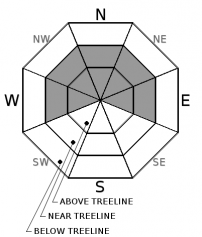
Avalanche Problem 1: Wind Slab
-
Character ?

-
Aspect/Elevation ?
-
Likelihood ?CertainVery LikelyLikelyPossible
 Unlikely
 -
Size ?HistoricVery LargeLargeSmall

Wind slabs continue to be the primary concern near and above treeline. Reactive slabs were observed on northerly aspects yesterday near the top of leeward terrain. With 4 more inches of snow received last night, and 6 inches or more expected today paired with strong southerly winds, these slabs will continue to grow in thickness and extend further down into this terrain. Look for scoured or textured snow surfaces as indicators of where wind has been blowing. Stay clear of wind loaded slopes greater than 35 degrees.
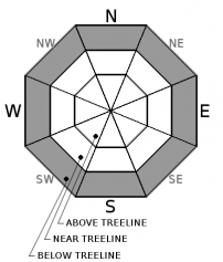
Avalanche Problem 2: Storm Slab
-
Character ?

-
Aspect/Elevation ?
-
Likelihood ?CertainVery LikelyLikelyPossible
Unlikely
Reactive storm slabs were observed below treeline yesterday on steep slopes where snow was moist to wet and not well bonded to the melt-freeze crust below. With continued snow expected today, these slabs may remain unstable and new slabs could form within the new storm snow.
A storm slab is a soft cohesive layer of new snow that breaks within the storm snow or on the old snow surface. Storm slabs are most dangerous on slopes with terrain traps, such as timber, gullies, over cliffs, or terrain features that make it difficult for a rider to escape off the side.
Forecast Discussion
A melt-freeze crust forming late Monday afternoon has locked in any new snow received Sunday night and Monday near and below treeline. However, up to 8 inches received since yesterday could be available for wind transport near treeline. At least 13 inches could be available at higher elevations. Six inches or more is expected today. Expect avalanche danger to increase to CONSIDERABLE throughout the day and as you ascend to higher elevations where temperatures have remained below freezing. CONSIDERABLE means human triggered avalanches are likely and natural avalanches are possible. When choosing routes today, evaluate the snowpack carefully and be conservative when making decisions.
We will issue our last avalanche advisory of the season this Sunday, April 16th.
Recent Observations
A tour of Grey Butte on Tuesday afternoon saw 3-6 inches of new snow atop a widespread melt-freeze crust up to at least 8000'. This melt-freeze crust formed late Monday afternoon. Snow levels were near 5000' with wet heavy conditions up to 7600'.
New snow did not bond well to the melt freeze crust. Moderate failures in column tests near 8000' occurred just below this crust. No propagation was seen in large column tests. Below 7600' the surface snow transitioned to moist-wet and was more slab-like. Small D1-1.5 storm slabs avalanches were sensitive to ski-trigger on slopes above 35 degrees (west aspects of Grey Butte). These avalanches had 4-6 inch crowns and were slow moving.
Wind loading was observed on north and northwest aspects and 4-6 inch wind slabs were reactive to ski trigger on rollovers. These slabs were isolated near the top of leeward areas.

Weather and Current Conditions
Weather Summary
A winter weather advisory will be in effect from 11 a.m. this morning to 11 p.m. this evening above 4500 feet. Expect blizzard conditions with gale force winds above tree-line today.
A low pressure system off the coast of Oregon and Washington will continue to bring unsettled weather today and tonight with the brunt of the storm tonight. Behind the front moving through is a cold air mass that could bring snow levels down to town by tomorrow. We could get over a foot of snow out of this one.
Expect a short break Friday and Saturday, and then more precipitation starting Sunday.
---------------------------------------------------------------------------------------------------------
In Mt Shasta City at 0500, we have a current temperature of 43 F
On Mt Shasta (South Side) in the last 24 hours...
Sand Flat - 6,750 ft. The current temperature is 32 degrees F. Temperatures have ranged from 29 F to 33 F. Snow on the ground totals 127 inches with 8 inches of new.
Old Ski Bowl - 7,600ft. The current temperature is 29 degrees F. Temperatures have ranged from 26 F to 30 F. Snow on the ground totals 213 inches with 8.5 inches of new.
Grey Butte - 8,000 feet. The current temperature is 28 degrees F. Temperatures have ranged from 24 F to 29 F. Winds have ranged from 10-20 mph with gusts to 35 mph, blowing mostly from the south and south southwest.
Mt Eddy Range (West side of Interstate-5)...
Castle Lake - 5,800 feet. The current temperature is 33 degrees F. Temperatures have ranged from 30 F to 34 F. Snow on the ground totals 112 inches with 3 inches of new.
Mt Eddy - 6,500 feet, the current temperature 31 degrees F. Temperatures have ranged from 29 F to 33 F. Snow on the ground measures 105 inches with 2 inches of new. Winds have averaged 3 mph out of the south with gusts up to 19 mph.
THIS SEASON PRECIPITATION for MT SHASTA CITY: Since October 1st (the wet season), we have received 54.60 inches of water, normal is 36.68 inches, putting us at 149% of normal. For the month of April, we have received 5.14 inches of water, normal is 1.22 inches, which is 421% of normal. And finally for the year of 2017, we received 33.44 inches of water, normal is 21.47 inches, putting us at 158% of normal.
Always check the weather before you attempt to climb Mt Shasta. Further, monitor the weather as you climb. Becoming caught on the mountain in any type of weather can compromise life and limb. Be prepared.
| 0600 temperature: | 32 |
| Max. temperature in the last 24 hours: | 33 |
| Average wind direction during the last 24 hours: | South |
| Average wind speed during the last 24 hours: | 10-20 mi/hr |
| Maximum wind gust in the last 24 hours: | 35 mi/hr |
| New snowfall in the last 24 hours: | 8 inches |
| Total snow depth: | 127 inches |
Two Day Mountain Weather Forecast
Produced in partnership with the Medford NWS
| For 7000 ft to 9000 ft | |||
|---|---|---|---|
|
Wednesday (4 a.m. to 10 p.m.) |
Wednesday Night (10 p.m. to 4 a.m.) |
Thursday (4 a.m. to 10 p.m.) |
|
| Weather | Snow. Breezy. Chance of precipitation is 100%. | Snow before 11pm, then snow showers after 11pm. The snow could be heavy at times. Breezy. Chance of precipitation is 100%. | Snow showers. Some thunder is also possible. Chance of precipitation is 90%. |
| Temperature (°F) | 34 | 24 | 31 |
| Wind (mi/hr) | South 20-30 mph, gusting to 50 | South 20-30 mph then 5-10 mph | South 10-15 mph |
| Precipitation SWE / Snowfall (in) | / 3-6 | / 3-7 | / 1-3 |
| For 9000 ft to 11000 ft | |||
| Wednesday | Wednesday Night | Thursday | |
| Weather | Snow. The snow could be heavy at times. Windy. Chance of precipitation is 100%. | Snow before 11pm, then snow showers after 11pm. The snow could be heavy at times. Windy. Chance of precipitation is 100%. | Snow showers. Some thunder is also possible. Windy. Chance of precipitation is 90%. |
| Temperature (°F) | 20 | 10 | 10 |
| Wind (mi/hr) | South 41-68 mph | Southwest 5-7 | Southwest 37-39 mph |
| Precipitation SWE / Snowfall (in) | / 5-7 | / 6-8 | / 2-3 |

