

You are here
Avalanche Advisory for 2017-12-01 06:45:39
- EXPIRED ON December 2, 2017 @ 6:45 amPublished on December 1, 2017 @ 6:45 am
- Issued by Nick Meyers - Shasta-Trinity National Forest
Bottom Line
LOW Danger and Normal Caution is advised for the Mt Shasta area backcountry. Early season conditions prevail with our barely usable snowpack above 6,500 feet. Watch for rocks, trees and other objects sticking above the snow surface.
Extremely firm and icy conditions will be encountered on Mt Shasta above 8,000 feet. Self-arrest is nearly impossible, even on low angle slopes. Be prepared. A climb of Mt Shasta with these conditions brings increased difficulty and consequences.


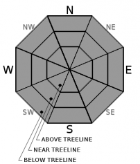
Avalanche Problem 1: Normal Caution
-
Character ?

-
Aspect/Elevation ?
-
Likelihood ?CertainVery LikelyLikelyPossible
 Unlikely
 -
Size ?HistoricVery LargeLargeSmall

Normal Caution advised. We currently do not have enough snow and/or concerning weak layers to host a good recipe for an avalanche.
Forecast Discussion
Season's Greetings from the Mt Shasta Avalanche Center! Welcome to the 2017/18 season. We are ready, we are set and here we go! The forecast area mountains started off this season with our first solid storm of the year in late October, followed by a couple more in November. These storms gave us several feet of snow on the mountain and in the Eddies. Sliders and riders were loving it. Late November brought warmer temperatures and rain which nixed the snowpack on the west side for the most part. On Mt Shasta, we have a firm and in some areas icy snowpack currently. Still, we are lacking enough snow to truley be concered about avalanches and have not observed any avalanches yet this season. Keep an eye on the weather and existing snow surface conditions as we move into December. You've likely heard the early season schpeal before.... watch out for rocks, trees and other things that are not covered by snow. Be safe!
Recent Observations
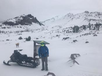
Rock solid snow conditions will be encountered in the backcountry currently. Snow on the ground can be found to the 6,500 foot level on Mt Shasta. A barely usable snowpack is available for recreation above 6,900 feet. Coverage is decent, with average snow heights of 50-90 cm. In the lower portion of the Old Ski Bowl, 65 to 70 cm snow heights were observed yesterday. Typical early season conditions prevail... Rocks, trees, shrubs and/or any other objects not buried by snow are certainly sticking out and visible, but easily avoidable. As soon as we get any fresh snow, these hazards will lurk below the snow surface. Use caution.
Above 8,000 feet, snow surface conditions are smooth and icy. Ridgelines above treeline are primarily scoured. These facts should be noted by any climbers and/or ski mountaineers. Slide for life conditions are present on the mountain. Some low angle slopes were nearly impossible to skin up and a slip and fall could result in disaster. Self arrest would be impossible. Further, many snaggletooth rocks protrude from the snow surface and a fall would likely send you into one of many said rocks. Do not take these conditions lightly.
Castle Lake and Mt Eddy are still looking pretty dirty. Recreation is on hold for now in these areas. Some snow is on the ground, but not enough for quality fun!
Click here to view recent photos from the Old Ski Bowl yesterday
Weather and Current Conditions
Weather Summary
A weak high pressure system has built into the area and will persist today. Low clouds and valley fog may be seen this morning. The stratus will gradually lift, giving way to partly cloudy skies and a bit of sun. That said, expect high clouds to filter into the Mt Shasta area this afternoon in advance of a strong cold front. Most notable with this system are high winds. Winds will increase throughout the day tommorrow out of the south/southwest. A quarter inch of water is forecast to come with this small storm and will fall tomorrow during daylight hours. Snow levels will linger around 4,600 feet.
=============================================================================
THIS SEASON PRECIPITATION for MT SHASTA CITY: Since October 1st (the wet season), we have received 5.54 inches of water, normal is 7.36 inches, putting us at 75% of normal. For the month of November, we received 4.89 inches of water, normal is 5.08 inches, which is 96% of normal. And finally for the year of 2017, we received 44.53 inches of water, normal is 35.36 inches, putting us at 125% of normal.
Always check the weather before you attempt to climb Mt Shasta. Further, monitor the weather as you climb. Becoming caught on the mountain in any type of weather can compromise life and limb. Be prepared.
| 0600 temperature: | 29 |
| Max. temperature in the last 24 hours: | 41 |
| Average wind direction during the last 24 hours: | Northwest |
| Average wind speed during the last 24 hours: | 5-10 mi/hr |
| Maximum wind gust in the last 24 hours: | 36 mi/hr |
| New snowfall in the last 24 hours: | 0 inches |
| Total snow depth: | 12 inches |
Two Day Mountain Weather Forecast
Produced in partnership with the Medford NWS
| For 7000 ft to 9000 ft | |||
|---|---|---|---|
|
Friday (4 a.m. to 10 p.m.) |
Friday Night (10 p.m. to 4 a.m.) |
Saturday (4 a.m. to 10 p.m.) |
|
| Weather | Mostly sunny | A 30 percent chance of snow after 4am. Mostly cloudy. | Snow likely, mainly between 10am and 4pm, then snow showers after 4pm. The snow could be heavy at times. Breezy. Chance of precipitation is 80%. |
| Temperature (°F) | 37 | 28 | 31, falling |
| Wind (mi/hr) | North/Northeast, becoming south 5-10 | South/Southeast 10-15 with gusts to 20 mph | South 20-25 with gusts to 35 mph |
| Precipitation SWE / Snowfall (in) | / 0 | / 0-.5 | / 3-5 |
| For 9000 ft to 11000 ft | |||
| Friday | Friday Night | Saturday | |
| Weather | Mostly sunny. Windy. Wind chill values as low as zero. | A 30 percent chance of snow after 4am. Mostly cloudy. Windy. Wind chill values as low as -3. | Snow, mainly after 10am. The snow could be heavy at times. Windy. Wind chill values as low as -23. Chance of precipitation is 80%. |
| Temperature (°F) | 24 | 21 | 8 |
| Wind (mi/hr) | West/Southwest 20-30 mph, increasing to 30-35 mph in the afternoon. Gusts could reach 50+ mph. | Southwest 0 | Southwest 40-50 mph with gusts higher |
| Precipitation SWE / Snowfall (in) | / 0 | / 0-.5 | / 4-8 |

