

You are here
Avalanche Advisory for 2017-12-27 06:16:19
- EXPIRED ON December 28, 2017 @ 6:16 amPublished on December 27, 2017 @ 6:16 am
- Issued by Aaron Beverly - Mount Shasta Avalanche Center
Bottom Line
Avalanche danger is LOW at all elevations. Normal caution is advised. Sparse coverage and firm icy slopes present significant travel hazards in the backcountry.


Avalanche Problem 1: Normal Caution
-
Character ?

-
Aspect/Elevation ?
-
Likelihood ?CertainVery LikelyLikelyPossible
 Unlikely
 -
Size ?HistoricVery LargeLargeSmall

Avalanches are unlikely throughout the advisory area. Exercise normal caution. Normal caution means:
- Always watch for isolated slabs.
- Basic avalanche rescue skills are essential when traveling in avalanche terrain.
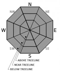
Terrain above treeline will be challenging and dangerous. Arresting a fall in current conditions will be difficult. Bring an ice axe, crampons, and a helmet with the knowledge and practice to use them. Watch out for rocks.
Forecast Discussion
If you like to golf, go golf. If you like to bike, go bike. If you like to ski, go ski. Look for favorable snow surfaces by mid-afternoon. We are in a weather cycle suitable for most outdoor activities. Be safe and enjoy whatever you like to do. We may see a return to winter conditions after next week so take advantage of what the current weather has to offer. Avalanche danger is LOW at all elevations.
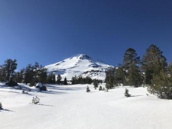
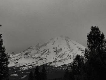
A widespread rain crust exists near and above treeline. This will present a challenge for those ascending on steep slopes. It may also create an ideal bed surface for avalanches when winter returns to the area.
Recent Observations
Near and above treeline, temperatures reached the mid 40s yesterday around 1 pm which were accompanied by moderate northwest winds. Similar conditions are expected today. Look for corn snow on slopes exposed to direct sun. You may still find low density recrystallized snow in shady areas below treeline from the December 3rd and 20th storms. A widespread rain crust exists near and above treeline.
Weather and Current Conditions
Weather Summary
The good news is that precipitation amounts are 107% of normal for the year. The bad news is that number may not look as rosy next week after a new year begins. But do not despair. Models show above normal precipitation for the next month and normal precipitation and temperatures for the next 3 months.
A warm front will move in tomorrow and Friday. The glob of high pressure off the coast of California will keep precipitation associated with it localized to Oregon and Washington. The high pressure may begin to dissipate towards the end of next week. Until then, expect current conditions to prevail.
-------------------------
THIS SEASON PRECIPITATION for MT SHASTA CITY: Since October 1st (the wet season), we have received 5.83 inches of water, normal is 13.93 inches, putting us at 42% of normal. For the month of December, we have received .29 inches of water, normal is 6.57 inches, which is 4.4% of normal. And finally for the year of 2017, we received 44.82 inches of water, normal is 41.93 inches, putting us at 107% of normal.
Always check the weather before you attempt to climb Mt Shasta. Further, monitor the weather as you climb. Becoming caught on the mountain in any type of weather can compromise life and limb. Be prepared.
24 Hour Weather Station Data @ 5:00 AM
| Weather Station | Temp (°F) | Wind (mi/hr) | Snow (in) | Comments | ||||||||
|---|---|---|---|---|---|---|---|---|---|---|---|---|
| Cur | Min | Max | Avg | Avg | Max Gust | Dir | Depth | New | Water Equivalent | Settlement | ||
| Mt. Shasta City (3540 ft) | 25 | 23 | 46 | 31 | 2 | N | ||||||
| Sand Flat (6750 ft) | 34 | 30 | 46 | 38 | 15 | 0 | 0 | 0 | ||||
| Ski Bowl (7600 ft) | 33 | 31 | 46 | 39 | 19 | 0 | 0 | 1 | ||||
| Gray Butte (8000 ft) | 31 | 31 | 44 | 38 | 19 | 43 | NW | |||||
| Castle Lake (5870 ft) | 38 | 38 | 49 | 42 | 0 | 0 | 0 | |||||
| Mount Eddy (6509 ft) | 31 | 31 | 46 | 37 | 2 | 7 | WSW | 0 | 0 | 0 | ||
| Ash Creek Bowl (7250 ft) | ||||||||||||
| Ash Creek Ridge (7895 ft) |
Two Day Mountain Weather Forecast
Produced in partnership with the Medford NWS
| For 7000 ft to 9000 ft | |||
|---|---|---|---|
|
Wednesday (4 a.m. to 10 p.m.) |
Wednesday Night (10 p.m. to 4 a.m.) |
Thursday (4 a.m. to 10 p.m.) |
|
| Weather | Mostly sunny | Mostly clear | Mostly Sunny |
| Temperature (°F) | 42 | 33 | 48 |
| Wind (mi/hr) | Northwest 9-11 mph | Northwest 11-13 mph, gusts up to 20 | West/Northwest 13-15 mph, gusts up to 23 |
| Precipitation SWE / Snowfall (in) | / 0 | / 0 | / 0 |
| For 9000 ft to 11000 ft | |||
| Wednesday | Wednesday Night | Thursday | |
| Weather | Partly cloudy. Windy. | Mostly clear. Windy. | Mostly sunny. Windy |
| Temperature (°F) | 28 | 31 | 31 |
| Wind (mi/hr) | West 49 mph, gusts up to 75 | West 0 | West/Northwest 28-33 mph, gusts up to 50 |
| Precipitation SWE / Snowfall (in) | / 0 | / 0 | / 0 |

