

You are here
Avalanche Advisory for 2017-12-31 06:50:25
- EXPIRED ON January 1, 2018 @ 6:50 amPublished on December 31, 2017 @ 6:50 am
- Issued by Andrew Kiefer - Mt Shasta Avalanche Center
Bottom Line
LOW avalanche danger and normal caution continue. Generally safe avalanche conditions exist. Sparse coverage and firm and icy slopes present significant travel hazards in the backcountry.


Avalanche Problem 1: Normal Caution
-
Character ?

-
Aspect/Elevation ?
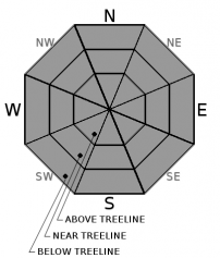
-
Likelihood ?CertainVery LikelyLikelyPossible
 Unlikely
 -
Size ?HistoricVery LargeLargeSmall

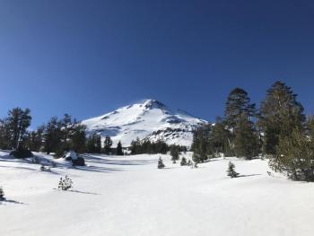
Normal caution is advised. The firm, icy, and thin snowpack continues to create backcountry travel hazards. Moving through steep terrain above treeline is challenging and dangerous. Arresting a fall in these conditions would be difficult. Watch out for rocks. Low angle slopes with smooth ground cover offer the best skiing and riding conditions.
- Ski and ride one at a time in avalanche terrain.
- Don’t regroup in run-out zones.
- Avalanche rescue skills are always essential when you travel in avalanche terrain.
Forecast Discussion
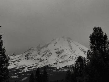
For several days, clear and warm weather conditions have remained steady, and our snowpack has experienced very little change. A re-cap of our season: October and November storms laid a shallow snowpack at high elevations on Mount Shasta. During Thanksgiving week, it rained up to 10,000ft. This rain event was followed by cold and clear weather which capped the snow surface at 7,000ft and above with a crust, while below, it eliminated any existing snow on the ground. We have had two small storm events this December totaling 10 inches of snow and less than 1 inch of water. Otherwise, high pressure has dominated our weather pattern. Precipitation is well below average, and a large portion of our advisory area is free of snow. Mount Shasta and Ash Creek Butte are the only areas with a (barely) usable snowpack.
Recent Observations
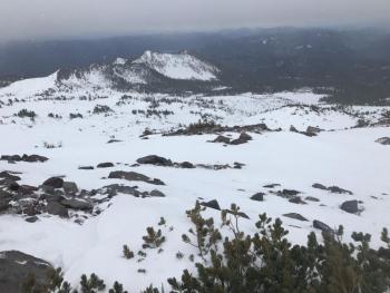
The snowline slowly creeps upward. Very little coverage exists below 6,500ft. The height of snow ranges from 30-100cm between 6,500-9,500ft. The rain crust that formed on Thanksgiving continues to lock up the lower snowpack. This slick, icy layer is the primary snow surface near and above treeline. On north and east aspects below treeline, 20-25cm of recycled powder (the December 3rd and December 20th storms) exists at the snow surface. On south and some west aspects, near and above treeline, patches of corn snow can be found. Snowpack stability is very good throughout the advisory area. Rocks, down trees, small tree tops and bushes are widespread.
Weather and Current Conditions
Weather Summary
A quiet weather pattern will finish off December and bring in the New Year on a dry note. Weak temperature inversions continue. Partly cloudy skies are expected today and tomorrow with high temperatures reaching the mid 40s to lower 50s. Southerly winds will blow at light to moderate speeds. Very low chances for precipitation begin on Tuesday and last through the week. Freezing levels should remain high during this time. At best, terrain above treeline will receive light snow flurries. More substantial chances for precipitation begin Thursday, but don’t get your hopes up. Warm temperatures will continue through the end of the week. Quite a bit of uncertainty exists regarding the long term forecast.
CLICK HERE for information from the NOAA Climate Prediction Center
-------------------------
THIS SEASON PRECIPITATION for MT SHASTA CITY: Since October 1st (the wet season), we have received 5.83 inches of water, normal is 14.96 inches, putting us at 39% of normal. For the month of December, we have received .29 inches of water, normal is 7.60 inches, which is 4% of normal. And finally for the year of 2017, we received 44.82 inches of water, normal is 42.96 inches, putting us at 104% of normal.
Always check the weather before you attempt to climb Mt Shasta. Further, monitor the weather as you climb. Becoming caught on the mountain in any type of weather can compromise life and limb. Be prepared.
24 Hour Weather Station Data @ 4:00 AM
| Weather Station | Temp (°F) | Wind (mi/hr) | Snow (in) | Comments | ||||||||
|---|---|---|---|---|---|---|---|---|---|---|---|---|
| Cur | Min | Max | Avg | Avg | Max Gust | Dir | Depth | New | Water Equivalent | Settlement | ||
| Mt. Shasta City (3540 ft) | 36 | 34 | 53 | 41 | 1 | N | ||||||
| Sand Flat (6750 ft) | 34 | 33 | 46 | 38 | 15 | 0 | 0 | 0 | ||||
| Ski Bowl (7600 ft) | 37 | 34 | 43 | 39 | 19 | 0 | 0 | 0 | ||||
| Gray Butte (8000 ft) | 36 | 35 | 41 | 37 | 16 | 43 | WNW | |||||
| Castle Lake (5870 ft) | 43 | 39 | 48 | 42 | 9 | 0 | 0 | |||||
| Mount Eddy (6509 ft) | 39 | 35 | 41 | 38 | 2 | 3 | W | 10 | 0 | 0 | ||
| Ash Creek Bowl (7250 ft) | station down | |||||||||||
| Ash Creek Ridge (7895 ft) | station down |
Two Day Mountain Weather Forecast
Produced in partnership with the Medford NWS
| For 7000 ft to 9000 ft | |||
|---|---|---|---|
|
Sunday (4 a.m. to 10 p.m.) |
Sunday Night (10 p.m. to 4 a.m.) |
Monday (4 a.m. to 10 p.m.) |
|
| Weather | Mostly Sunny | Mostly Cloudy | Partly Sunny |
| Temperature (°F) | 46 | 39 | 47 |
| Wind (mi/hr) | South 5-10 mph | South/Southeast 5 mph | South 0-5 mph |
| Precipitation SWE / Snowfall (in) | / 0 | / 0 | / 0 |
| For 9000 ft to 11000 ft | |||
| Sunday | Sunday Night | Monday | |
| Weather | Mostly Sunny | Mostly Cloudy and Breezy | Partly Sunny |
| Temperature (°F) | 31 | 26 | 29 |
| Wind (mi/hr) | South/Southwest 15-20 mph, gusting 25 mph | South/Southwest 0 | Southwest 15-20 mph, gusting 30 mph |
| Precipitation SWE / Snowfall (in) | / 0 | / 0 | / 0 |

