

You are here
Avalanche Advisory for 2018-01-20 06:03:19
- EXPIRED ON January 21, 2018 @ 6:03 amPublished on January 20, 2018 @ 6:03 am
- Issued by Nick Meyers - Shasta-Trinity National Forest
Bottom Line
MODERATE avalanche danger exists for the wind slab problem on Mount Shasta today. Human triggered wind slabs will be stubborn to trigger, but are possible. Expect wind slabs specifically on N-NE-E-SE facing slopes above 9,000 feet. For all other aspects and elevations, the avalanche danger is LOW. Firm, icy surfaces exist on windward, exposed ridgelines and a slide for life is possible without immediate self-arrest. Watch for falling rime ice.


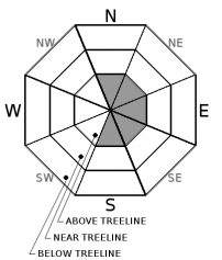
Avalanche Problem 1: Wind Slab
-
Character ?

-
Aspect/Elevation ?
-
Likelihood ?CertainVery LikelyLikelyPossible
 Unlikely
 -
Size ?HistoricVery LargeLargeSmall

Recent observations have indicated that wind slabs are generally stable. Still, a lot of new, cold snow is available for transport. If a wind slab were to be triggered, avalanche size to D2 is possible. Layer of failure would likely occur somewhere within the slab at a density change. Wind slabs are notoriously difficult to predict. Simply, look for and avoid areas of recently wind drifted snow on steep slopes. Uses clues such as blowing snow, cornice features, wind pillows, snow surface sculpting, and cracking/collapsing to identify likely areas of unstable snow.
Forecast Discussion
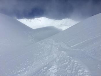
While stability has appeared to be good on the mountain, continue to use caution with regards to the wind slab problem today. Remember, it doesn't have to be snowing for there to be avalanche danger. Wind can deposit snow onto leeward slopes 10 times faster than snow falling from the sky. Below treeline, watch out for rocks as they are well hidden just below the new snow surface.
Recent Observations
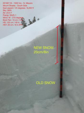
- Avalanche Gulch and Old Ski Bowl (south side of Mount Shasta), height of new snow: 15-20 cm (6-8 in)
- Cold and dry snow, even distribution throughout terrain up to 9,000 feet.
- Above 9,000 ft, exposed ridgelines and moraine convexities are scoured down to slick, hard and icy old snow surface
- Leeward NE-E-SE-S slopes, drifts of snow up to 60 cm (3 ft) were observed
- Wind slabs have formed above 9,000 ft on N-NE-E-SE-S facing slopes
- No recent avalanches have been observed
- Small cornices were noted along select portions of Green Butte Ridge with a couple small collapses
- Temperatures have remained below freezing on the mountain (12 degrees F at 10,000 ft, mid afternoon)
- Many rocks buried and lurking beneath new snow.
- Rime ice plastered to exposed rocks. Wear a helmet!
- Castle Lake, Mt Eddy and Pilgrim Creek Snowmobile Park need additional snow for a usable snowpack.
Weather and Current Conditions
Weather Summary
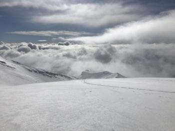
We are in a holding pattern today. Expect partly cloudy to mostly clear skies overall. All focus is on a strong front that will bring gale force southwest winds and snow to the area tomorrow morning. A winter storm watch is in effect from Sunday morning through Sunday evening, issued by the NWS Medford. Snow-water equivalent models suggest upwards of .64 inches of water expected with snow levels near town limits. An ongoing storm series will continue next week, with the next significant front to arrive on Tuesday.
Always check the weather before you attempt to climb Mt Shasta. Further, monitor the weather as you climb. Becoming caught on the mountain in any type of weather can compromise life and limb. Be prepared.
24 Hour Weather Station Data @ 4:00 AM
| Weather Station | Temp (°F) | Wind (mi/hr) | Snow (in) | Comments | ||||||||
|---|---|---|---|---|---|---|---|---|---|---|---|---|
| Cur | Min | Max | Avg | Avg | Max Gust | Dir | Depth | New | Water Equivalent | Settlement | ||
| Mt. Shasta City (3540 ft) | 27 | 27 | 39 | 32 | 0 | N | ||||||
| Sand Flat (6750 ft) | 14 | 13 | 27 | 19 | 15 | 0 | 0 | 0 | ||||
| Ski Bowl (7600 ft) | 14 | 13 | 25 | 17 | 30 | 0 | 0 | 0 | ||||
| Gray Butte (8000 ft) | 14 | 12 | 25 | 17 | 9 | 18 | WNW | |||||
| Castle Lake (5870 ft) | 31 | 31 | 33 | 32 | 0 | 0 | 0 | |||||
| Mount Eddy (6509 ft) | 18 | 17 | 32 | 27 | 0 | 6 | VAR | 17.5 | 0 | 0 | ||
| Ash Creek Bowl (7250 ft) | Station down | |||||||||||
| Ash Creek Ridge (7895 ft) | Station down |
Two Day Mountain Weather Forecast
Produced in partnership with the Medford NWS
| For 7000 ft to 9000 ft | |||
|---|---|---|---|
|
Saturday (4 a.m. to 10 p.m.) |
Saturday Night (10 p.m. to 4 a.m.) |
Sunday (4 a.m. to 10 p.m.) |
|
| Weather | Partly cloudy | Increasing clouds, snow likely after 4am | Snow, heavy at times, breezy |
| Temperature (°F) | 28 | 22 | 31 |
| Wind (mi/hr) | Northwest 0-5 mph | Southwest 5-10 mph | South 15-25 mph |
| Precipitation SWE / Snowfall (in) | / 0 | / 0 | / 6-8 |
| For 9000 ft to 11000 ft | |||
| Saturday | Saturday Night | Sunday | |
| Weather | Partly cloudy, slight chance of snow showers | Increasing clouds, snow likely after 4am | Snow, heavy at times, windy |
| Temperature (°F) | 13 | 13 | 21 |
| Wind (mi/hr) | Northwest 10-15 mph | West 0 | Southwest 30-40 mph with gusts higher |
| Precipitation SWE / Snowfall (in) | / 0 | / 0 | / 6-10 |
Season Precipitation for Mount Shasta City
| Period | Measured (in) | Normal (in) | Percent of Normal (%) |
|---|---|---|---|
| From Oct 1, 2025 (the wet season) | 8.64 | 19.69 | 44 |
| Month to Date (since Jun 1, 2026) | 2.81 | 4.48 | 63 |
| Year to Date (since Jan 1, 2026) | 2.81 | 4.48 | 63 |

