

You are here
Avalanche Advisory for 2018-01-24 07:00:08
- EXPIRED ON January 25, 2018 @ 7:00 amPublished on January 24, 2018 @ 7:00 am
- Issued by Andrew Kiefer - Mt Shasta Avalanche Center
Bottom Line
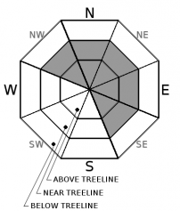
The avalanche danger will rise to CONSIDERABLE above treeline by this afternoon. Fresh wind slabs will form near and above treeline on SE-E-NE-N-NW aspects. Natural avalanches are possible and human triggered avalanche are likely. Heightened avalanche danger is expected through the end of the week as an active weather pattern continues.


Avalanche Problem 1: Wind Slab
-
Character ?

-
Aspect/Elevation ?
-
Likelihood ?CertainVery LikelyLikelyPossible
 Unlikely
 -
Size ?HistoricVery LargeLargeSmall

Strong southwest winds and new snow will form fresh wind slabs 2-3 feet thick near and above treeline on SE-E-NE-N-NW aspects. Wind slabs will grow in size and distribution throughout day. By the afternoon, natural wind slab avalanches will be possible, and human triggering will be likely. Be especially careful of leeward slopes and cross-loaded terrain features 35 degrees and steeper above treeline. Today, wind slab avalanches will be large enough to bury, injure, or kill a person. Wind slabs can be avoided by sticking to sheltered or wind scoured areas.
Forecast Discussion
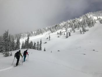
Dangerous avalanche conditions will exist in the backcountry by this afternoon. Touchy wind slabs will be widespread near and above treeline. Monitor conditions as they change rapidly throughout the day. Watch for obvious signs of instability like recent avalanches, shooting cracks and whumphs. Look for signs of wind loading like blowing snow, cornices, textured snow surfaces and hollow sounding snow. Check to see how the new snow is bonding to the old snow surface. Expect low visibility and challenging travel conditions. Careful snowpack evaluation, cautious route finding and conservative decision-making are essential today.
Recent Observations
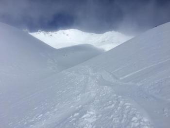
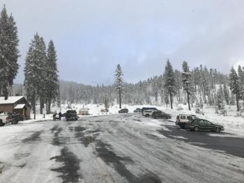
No new snow has fallen as of 7am this morning. Skies remained cloudy yesterday with windy conditions above treeline. A lenticular cloud consumed the upper mountain for most of the day. At 8,000 ft, winds averaged 15-20 mph with 35 mph gusts blowing out of the NW shifting SW overnight. Snow surfaces are variable. Near and below treeline, low-density powder snow can be found on W-N-E aspects, while a thin sun crust exists on steep, open south facing slopes. Above treeline, snow surfaces are wind textured, with many exposed terrain features and N-NW-W aspects scoured down to a slick, icy old snow surface.
Weather and Current Conditions
Weather Summary
The arrival of a strong frontal system has been slightly delayed, but heavy snowfall will begin mid-morning. The NWS has issued a WINTER STORM WARNING IN EFFECT UNTILL 10PM PST THURSDAY. For today, expect strong southwest winds, high temperatures near 30 degrees, and 1 inch of water by 10pm. Snow levels should begin at 4,000 ft, dropping to town by this afternoon. Snow accumulations of 10-15 inches are expected at 6,000 ft, with more snow likely at higher elevations. A second front will arrive tomorrow, dropping snow levels further and bringing another round of precipitation. Tonight, we should pick up 2-4 inches of snow, with 3-8 inches forecast for tomorrow. Today will be a potent start to an active weather pattern that will continue through early next week.
24 Hour Weather Station Data @ 6:00 AM
| Weather Station | Temp (°F) | Wind (mi/hr) | Snow (in) | Comments | ||||||||
|---|---|---|---|---|---|---|---|---|---|---|---|---|
| Cur | Min | Max | Avg | Avg | Max Gust | Dir | Depth | New | Water Equivalent | Settlement | ||
| Mt. Shasta City (3540 ft) | 37 | 27 | 43 | 35 | 4 | SE | ||||||
| Sand Flat (6750 ft) | 28 | 23 | 37 | 29 | 18 | 0 | 0 | 0 | ||||
| Ski Bowl (7600 ft) | 23 | 23 | 34 | 29 | 35 | 0 | 0 | 0 | ||||
| Gray Butte (8000 ft) | 23 | 21 | 30 | 25 | 15 | 31 | WNW | |||||
| Castle Lake (5870 ft) | 28 | 26 | 34 | 29 | 3 | 0 | 0 | |||||
| Mount Eddy (6509 ft) | 27 | 26 | 37 | 28 | 2 | 10 | S | 20 | 0 | 0 | ||
| Ash Creek Bowl (7250 ft) | station down | |||||||||||
| Ash Creek Ridge (7895 ft) | station down |
Two Day Mountain Weather Forecast
Produced in partnership with the Medford NWS
| For 7000 ft to 9000 ft | |||
|---|---|---|---|
|
Wednesday (4 a.m. to 10 p.m.) |
Wednesday Night (10 p.m. to 4 a.m.) |
Thursday (4 a.m. to 10 p.m.) |
|
| Weather | Heavy snow and windy. Chance of precipitation 100%. | Snow showers. Chance of precipitation 90%. | Snow showers. Chance of precipitation 90%. |
| Temperature (°F) | 30 | 19 | 23 |
| Wind (mi/hr) | South 15-25 mph | South/Southwest 15-20 mph | South 15-20 mph |
| Precipitation SWE / Snowfall (in) | / 15-21 | / 3-5 | / 6-10 |
| For 9000 ft to 11000 ft | |||
| Wednesday | Wednesday Night | Thursday | |
| Weather | Heavy snow and windy. Chance of precipitation 100%. Wind chill values as low as -14. | Snow showers. Chance of precipitation 90%. Wind chill values as low as -26. | Snow showers and windy. Chance of precipitation 90%. Wind chill values as low as -21. |
| Temperature (°F) | 19 | 4 | 17 |
| Wind (mi/hr) | South/Southwest 40-50 mph, increasing throughout the day | West/Southwest 24-30 | Southwest 35-45 mph, gusting 60+ mph |
| Precipitation SWE / Snowfall (in) | / 24-30 | / 3-7 | / 6-10 |
Season Precipitation for Mount Shasta City
| Period | Measured (in) | Normal (in) | Percent of Normal (%) |
|---|---|---|---|
| From Oct 1, 2025 (the wet season) | 9.07 | 20.13 | 45 |
| Month to Date (since Jun 1, 2026) | 3.24 | 4.92 | 66 |
| Year to Date (since Jan 1, 2026) | 3.24 | 4.92 | 66 |

