

You are here
Avalanche Advisory for 2018-01-25 06:41:38
- EXPIRED ON January 26, 2018 @ 6:41 amPublished on January 25, 2018 @ 6:41 am
- Issued by Nick Meyers - Shasta-Trinity National Forest
Bottom Line
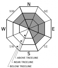
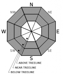
Multiple avalanche problems give way to CONSIDERABLE avalanche danger today, near and above treeline, all aspects. Below treeline, expect MODERATE avalanche danger. Wind slab, Loose-Dry and Storm Slab instabilities are possible, both natural and human triggered. Careful snowpack evaluation, cautious route finding and conservative decision-making are essential today.


Avalanche Problem 1: Wind Slab
-
Character ?

-
Aspect/Elevation ?
-
Likelihood ?CertainVery LikelyLikelyPossible
 Unlikely
 -
Size ?HistoricVery LargeLargeSmall

Strong southwest winds and new snow continue. Fresh, thick wind slabs near and above treeline could be sensitive to trigger. Natural wind slab avalanches are possible, and human triggering will be likely. Be especially careful of leeward slopes and cross-loaded terrain features 35 degrees and steeper above treeline. Wind slabs can be avoided by sticking to sheltered or wind scoured areas.
Avalanche Problem 2: Loose Dry
-
Character ?

-
Aspect/Elevation ?
-
Likelihood ?CertainVery LikelyLikelyPossible
Unlikely
-
Size ?HistoricVery LargeLargeSmall
Loose-dry avalanches are very likely today on slopes steeper than 37 degrees, below and near treeline, all aspects. Look for loose snow surface texture in sheltered areas, as opposed to wind-affected, refrozen, or other stiff snow textures. Loose dry avalanches can be triggered by falling snow chunks, cornice fall, rock fall or most commonly, a slider or rider. Sluffs can run fast and far and can sometimes trigger slabs in certain conditions. Small slides could be dangerous with terrain traps or cliffs.
Avalanche Problem 3: Storm Slab
-
Character ?

-
Aspect/Elevation ?

-
Likelihood ?CertainVery LikelyLikelyPossible
Unlikely
-
Size ?HistoricVery LargeLargeSmall
Storm snow instabilities form when a storm deposits a slab of stronger snow over a weaker layer of storm snow, or when the upper layers of storm snow settle and strengthen into a stronger slab resting on relatively weaker storm snow. Storm slabs could become an increasing concern as continued snowfall builds and temperatures warm over the coming days. Settlement in the new snow can strengthen the snowpack, or potentially form a slab over weak snow. Storm snow weak layers are typically thin and have only slight variations in characteristics from the slab above and the bed surface below. As a result they can be extremely difficult to observe directly. Snowpack tests for storm snow instability should be made within the storm snow itself as well as at the interface between the storm snow and old snow. Standard tests such as the compression test are of limited use in detecting storm snow instability—the new snow is often very soft and compression test columns tend to break apart rather than transmit force to the weak layer and create failure. Ski cutting is only advised for shallow storm snow instabilities on small terrain features where no terrain traps exist and the consequences of being caught are low. Storm snow instabilities can sometimes be detected by looking for shooting cracks when walking just above a previously cut ski track.
Forecast Discussion
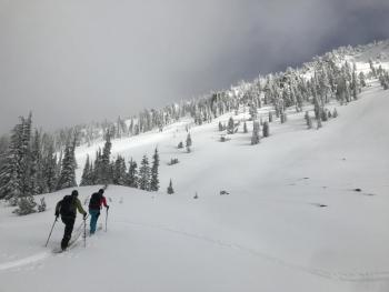
Multiple avalanche problems and continued stormy weather will warrant all backcountry users to use extra caution today. One can almost always stay out of trouble by watching for red flags of avalanche danger. These are Mother Natures NEON signs of unstable snow. Watch for obvious signs of instability like recent avalanches, shooting cracks and whumphs. Look for signs of wind loading like blowing snow, cornices, textured snow surfaces and hollow sounding snow. Check to see how the new snow is bonding to the old snow surface. Expect low visibility and challenging travel conditions.
Recent Observations
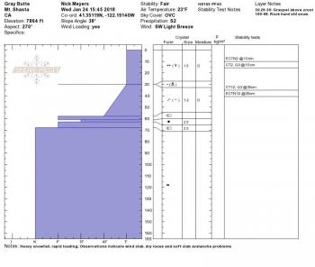
- Yesterday's storm produced .85" SWE and 25 to 30 cm (10-12 in) of new snow above 7,500 feet in a 12 hour period (0700 - 1900 hrs)
- Boot penetration: 40 cm (15 in) / Ski Penetration: 10 cm (4 in) at base of Grey Butte, west side
- The heaviest precipitation occurred between 1100-1200 hrs with a notable 3 inches/hour!
- Winds averaged in the mid to high teens with gusts into the 20-30 mph range, blowing from the W/SW
- Fresh cornices and small wind slabs were easily triggered in micro terrain along the north ridge of Grey Butte, near and above treeline
- Loose-dry avalanches were also easily triggered within top 10 cm of fresh snow on slopes steeper than 37 degrees, below and near treeline on Grey Butte
- Storm slab characteristics were observed primarily near treeline, though no storm slabs were observed or triggered
- Temperatures remained well below freezing for the day - 23 degrees F at 7,864 ft / 1545 hrs
- No recent, natural avalanches were observed. Visibility was poor.
Weather and Current Conditions
Weather Summary
A WINTER STORM WARNING AND WINTER WEATHER ADVISORY REMAIN IN EFFECT UNTIL 10 PM PST THIS EVENING, issued by the NWS Medford at 310 AM PST today. Ongoing precipitation will occur at least through midday. The frontal boundary has pushed on shore and snow showers should begin this morning. Snow levels will drop to town and perhaps lower. This next round will not be as strong as yesterday, but we can still expect an additional half inch of SWE in the mountains, producing 4-6 inches of snow above Bunny Flat (6,950 ft) and perhaps a bit less on the west side of the forecast area. Showers will continue through tonight and into Friday, but the heaviest of precipitation will have passed by this evening.
24 Hour Weather Station Data @ 5:00 AM
| Weather Station | Temp (°F) | Wind (mi/hr) | Snow (in) | Comments | ||||||||
|---|---|---|---|---|---|---|---|---|---|---|---|---|
| Cur | Min | Max | Avg | Avg | Max Gust | Dir | Depth | New | Water Equivalent | Settlement | ||
| Mt. Shasta City (3540 ft) | 37 | 27 | 43 | 35 | 4 | SE | ||||||
| Sand Flat (6750 ft) | 14 | 13 | 29 | 22 | 26 | 8 | .36 | 1 | suspect SWE | |||
| Ski Bowl (7600 ft) | 13 | 10 | 25 | 19 | 45 | 11 | .85 | 1 | ||||
| Gray Butte (8000 ft) | 12 | 11 | 25 | 19 | 15 | 37 | W | |||||
| Castle Lake (5870 ft) | 19 | 18 | 30 | 25 | 12 | 8.5 | 1 | |||||
| Mount Eddy (6509 ft) | 18 | 15 | 28 | 23 | 2 | 13 | SW | 28 | 8.5 | .5 | ||
| Ash Creek Bowl (7250 ft) | station down | |||||||||||
| Ash Creek Ridge (7895 ft) | station down |
Two Day Mountain Weather Forecast
Produced in partnership with the Medford NWS
| For 7000 ft to 9000 ft | |||
|---|---|---|---|
|
Thursday (4 a.m. to 10 p.m.) |
Thursday Night (10 p.m. to 4 a.m.) |
Friday (4 a.m. to 10 p.m.) |
|
| Weather | Snow showers, breezy, chance of snow 100% | Mostly cloudy, snow showers, chance of snow 90% | Mostly cloudy, chance of snow showers 40% |
| Temperature (°F) | 26 | 18 | 28 |
| Wind (mi/hr) | South 10-15 mph | Southwest 5-10 mph | South 5-10 mph |
| Precipitation SWE / Snowfall (in) | / 4-6 | / 1-3 | / .5 |
| For 9000 ft to 11000 ft | |||
| Thursday | Thursday Night | Friday | |
| Weather | Snow showers, windy, chance of precipitation 100% | Snow showers, mainly before 10pm, windy, chance of precipitation 90% | Mostly cloudy, windy, chance of precipitation 50% |
| Temperature (°F) | 9 | 6 | 16 |
| Wind (mi/hr) | West/Southwest 25-35 mph | West/Southwest 5-7 | West/Southwest 15-25 mph |
| Precipitation SWE / Snowfall (in) | / 5-7 | / 2-4 | / .5 |
Season Precipitation for Mount Shasta City
| Period | Measured (in) | Normal (in) | Percent of Normal (%) |
|---|---|---|---|
| From Oct 1, 2025 (the wet season) | 10.00 | 20.79 | 48 |
| Month to Date (since Jun 1, 2026) | 4.17 | 5.58 | 75 |
| Year to Date (since Jan 1, 2026) | 4.17 | 5.58 | 75 |

