

You are here
Avalanche Advisory for 2018-04-02 06:54
- EXPIRED ON April 3, 2018 @ 6:54 amPublished on April 2, 2018 @ 6:54 am
- Issued by Andrew Kiefer - Mt Shasta Avalanche Center
Bottom Line
The avalanche danger is LOW at all elevations and NORMAL CAUTION is advised. Watch for slick snow surfaces and falling rime ice in alpine terrain on Mount Shasta.


Avalanche Problem 1: Normal Caution
-
Character ?

-
Likelihood ?CertainVery LikelyLikelyPossible
 Unlikely
 -
Size ?HistoricVery LargeLargeSmall

Generally safe avalanche conditions exist in the backcountry. LOW avalanche danger does not mean NO avalanche danger:
- Strong solar radiation and warm temperatures can cause loose wet avalanches. Travel when the snow surface is colder and stronger. Plan your trips to avoid crossing on or under very steep sunlit slopes during the peak heating hours of the day.
- Small cornices exist on easterly aspects above treeline. They may weaken and fall as the warm and sunny spring weather continues. Avoid traveling on top of or below these formations.
Forecast Discussion
The snowpack has responded well to the strong solar radiation and heat during the past week. All wet loose activity that has occurred has been small and inconsequential. Cooler temperatures and strong winds will likely limit wet loose activity and falling rime ice today. Regardless, if you see roller balls, or if you find the surface snow to be wet and unconsolidated, it’s time to change aspects or move to lower angle terrain. If you venture into the alpine, work to minimize your exposure to icefall with your terrain selection and your timing, and avoid being underneath rime ice formations during the warmest hours of the day.
Recent Observations
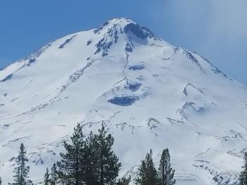
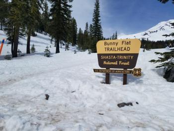
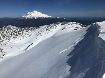
Yesterday, highs reached the upper 40s at the Old Ski Bowl while temperatures in town hit 64 degrees. Skies remained sunny until the early afternoon when winds picked up and a lenticular cloud formed on the upper mountain. The Gray Butte weather station reported strong to extreme NW winds averaging 15-25 mph with gusts to 63 mph. The south side of Mount Shasta was busy with skiers, snowmobilers and climbers. Smooth corn skiing was found in the morning on southerly slopes below 9,000 ft, while above, snow surfaces remained firm and icy throughout the day. Rime ice exists on alpine rock features. Coverage is good on Mount Shasta with a 4-8 ft deep snowpack found 7,000 ft and higher. The Sand Flat trails are still in good shape with 1-3 ft of coverage. The snowpack is melting quickly in the Pilgrim Creek Sno-Park, Castle Lake and Mount Eddy zones.
Weather and Current Conditions
Weather Summary
A cold front will exit the region this morning. Skies will start off partly cloudy, becoming mostly sunny by the afternoon. High temperatures for 7,000 ft will be in the lower 40s. Strong northwest winds will continue above treeline for now, but will die down tonight and shift to the west. Tuesday and Wednesday should remain dry. A series of disturbances will bring wet and windy weather Thursday through Saturday.
24 Hour Weather Station Data @ 6:00 AM
| Weather Station | Temp (°F) | Wind (mi/hr) | Snow (in) | Comments | ||||||||
|---|---|---|---|---|---|---|---|---|---|---|---|---|
| Cur | Min | Max | Avg | Avg | Max Gust | Dir | Depth | New | Water Equivalent | Settlement | ||
| Mt. Shasta City (3540 ft) | 45 | 38 | 64 | 51.5 | 4 | NW | ||||||
| Sand Flat (6750 ft) | station down | |||||||||||
| Ski Bowl (7600 ft) | 33.5 | 32.5 | 46 | 38.5 | 75 | 0 | 0 | 2 | ||||
| Gray Butte (8000 ft) | 33 | 33 | 45 | 37.5 | 16 | 63 | NW | |||||
| Castle Lake (5870 ft) | station down | |||||||||||
| Mount Eddy (6509 ft) | 33 | 31 | 47 | 39.5 | 2 | 11 | SE | 41.5 | 0.6 | 2 | ||
| Ash Creek Bowl (7250 ft) | station down | |||||||||||
| Ash Creek Ridge (7895 ft) | station down |
Two Day Mountain Weather Forecast
Produced in partnership with the Medford NWS
| For 7000 ft to 9000 ft | |||
|---|---|---|---|
|
Monday (4 a.m. to 10 p.m.) |
Monday Night (10 p.m. to 4 a.m.) |
Tuesday (4 a.m. to 10 p.m.) |
|
| Weather | Partly cloudy, then becoming sunny | Clear | Mostly sunny |
| Temperature (°F) | 41 | 27 | 48 |
| Wind (mi/hr) | NW 10-15 | N 5-10 | S 0-5 |
| Precipitation SWE / Snowfall (in) | / 0 | / 0 | / 0 |
| For 9000 ft to 11000 ft | |||
| Monday | Monday Night | Tuesday | |
| Weather | Partly cloudy and windy | Mostly clear | Mostly sunny |
| Temperature (°F) | 22 | 22 | 25 |
| Wind (mi/hr) | NW 30-40 | NW 0 | W 15-20 |
| Precipitation SWE / Snowfall (in) | / 0 | / 0 | / 0 |
Season Precipitation for Mount Shasta City
| Period | Measured (in) | Normal (in) | Percent of Normal (%) |
|---|---|---|---|
| From Oct 1, 2025 (the wet season) | 15.95 | 35.57 | 45 |
| Month to Date (since Jun 1, 2026) | 0.00 | 0.11 | 0 |
| Year to Date (since Jan 1, 2026) | 10.12 | 20.36 | 50 |

