

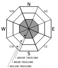
You are here
Avalanche Advisory for 2018-04-05 06:43
- EXPIRED ON April 6, 2018 @ 6:43 amPublished on April 5, 2018 @ 6:43 am
- Issued by Aaron Beverly - Mount Shasta Avalanche Center
Bottom Line
A significant storm is expected to bring over 2 inches of water to the forecast area by early Saturday morning. Below and near treeline elevations will receive this in the form of rain and wet snow. Avalanche danger will rise from LOW to MODERATE above treeline by late tonight as new snow and strong winds combine to form wind slabs. Avalanche danger is LOW at all other elevations.


Avalanche Problem 1: Wind Slab
-
Character ?

-
Aspect/Elevation ?
-
Likelihood ?CertainVery LikelyLikelyPossible
 Unlikely
 -
Size ?HistoricVery LargeLargeSmall

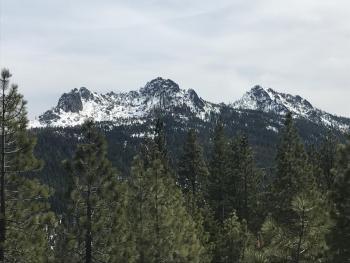
The timing of rising snow levels and precipitation will determine if there is enough dry snow available for wind slab formation. Snow levels are expected to begin at 7000 ft today and rise to 9000 ft or higher tomorrow. If the timing is right, elevations above 8000 ft may see up to 5 inches of snow by tomorrow morning. This combined with strong S winds will contribute to the development of wind slabs on leeward slopes late tonight. Firm icy snow surfaces above treeline may provide ideal bed surfaces for wind slab avalanches.
Avoid wind slabs by traveling in windward areas where snow surfaces have been eroded. Avoid slopes greater than 35 degrees where wind loading has occurred. Evaluate conditions as you travel in safe terrain by looking for signs of the wind slab problem:
- Smooth rounded wind pillows
- Hollow sounding snow
- Harder snow atop softer snow
- Shooting cracks
Forecast Discussion
Adventurers will be rewarded with great suffering if braving the mountain today and tomorrow. Strong gusty winds will accompany wet conditions that will only get wetter. Tomorrow, rising snow levels will be followed by 1.5 inches of rain. This may create loose wet avalanche concerns as new snow becomes saturated with water. Monitor the advisory over the next few days for updates on changing conditions. Be prepared to hunker down and keep dry.
Recent Observations
Relevant data from Gray Butte and Old Ski Bowl weather stations in the last 24 hours:
- Average temperature = 38 °F; high temperature = 46 °F.
- Water equivalent = 0.09 in. No snow accumulation.
- Snow settlement = 1.5 in.
- Light to moderate NW and W winds averaging 12 mi/hr, gusts up to 31 mi/hr.
Observations from the Old Ski Bowl yesterday afternoon:
- Height of snow (HS) = 150-200 cm (60-80 in).
- Trace of new snow above 8500 ft.
- No recent signs of instability. No loose wet avalanches.
- Snowpack stability good.
- 3-5 cm (1-2 in) of moist fist hard snow atop pencil hard melt forms up to 8500 ft.
- Firm icy conditions above 9000 ft, old wind textured snow surfaces.
Weather and Current Conditions
Weather Summary
A significant frontal system moves in today bringing over 2 inches of water to the forecast area. About 0.5 inches of this is expected today and tonight. Tomorrow and tomorrow night, 1.5 inches. This is gonna be a wet one. Snow levels will start at 7000 ft today and will rise up to 9000 ft by tomorrow. Snow levels may drop back to 5000 ft by late Saturday, but most of the precipitation will have fallen as rain by then. Above treeline elevations may see up to 5 inches of snow by early tomorrow morning and will be accompanied by strong SW winds, 30-40 mi/hr.
Another storm with lower snow levels appears to be lining up for next week. April's outlook indicates above average precipitation and normal temperatures.
24 Hour Weather Station Data @ 5:00 AM
| Weather Station | Temp (°F) | Wind (mi/hr) | Snow (in) | Comments | ||||||||
|---|---|---|---|---|---|---|---|---|---|---|---|---|
| Cur | Min | Max | Avg | Avg | Max Gust | Dir | Depth | New | Water Equivalent | Settlement | ||
| Mt. Shasta City (3540 ft) | 46 | 25 | 67 | 50.5 | 1 | N | ||||||
| Sand Flat (6750 ft) | station down | |||||||||||
| Ski Bowl (7600 ft) | 34 | 32.5 | 46 | 37.5 | 72 | 1.1 | 0.09 | 1.5 | ||||
| Gray Butte (8000 ft) | 32 | 31 | 44 | 35.5 | 12 | 31 | W | |||||
| Castle Lake (5870 ft) | station down | |||||||||||
| Mount Eddy (6509 ft) | 37 | 35 | 46.5 | 40.5 | 1 | 8 | SSE | 38.5 | 0.6 | 2 | ||
| Ash Creek Bowl (7250 ft) | station down | |||||||||||
| Ash Creek Ridge (7895 ft) | station down |
Two Day Mountain Weather Forecast
Produced in partnership with the Medford NWS
| For 7000 ft to 9000 ft | |||
|---|---|---|---|
|
Thursday (4 a.m. to 10 p.m.) |
Thursday Night (10 p.m. to 4 a.m.) |
Friday (4 a.m. to 10 p.m.) |
|
| Weather | Rain and snow. Breezy. Chance of precipitation is 100%. Little or no snow accumulation expected. | Rain. Chance of precipitation is 90%. | Rain. Breezy. Chance of precipitation is 90%. |
| Temperature (°F) | 37 | 33 | 43 |
| Wind (mi/hr) | S 10-15 | S 5-10 | S 10-15 |
| Precipitation SWE / Snowfall (in) | / 0 | / 0 | / 0 |
| For 9000 ft to 11000 ft | |||
| Thursday | Thursday Night | Friday | |
| Weather | Snow. Windy. Chance of precipitation is 100%. | Snow. Chance of precipitation is 90%. | Snow. Wind chill values as low as -5. Windy. Chance of precipitation is 90%. |
| Temperature (°F) | 32 | 30 | 37 |
| Wind (mi/hr) | SW 30-40 | SW 1-2 | SW 40-50 |
| Precipitation SWE / Snowfall (in) | / 1-2 | / 2-3 | / 4-5 |
Season Precipitation for Mount Shasta City
| Period | Measured (in) | Normal (in) | Percent of Normal (%) |
|---|---|---|---|
| From Oct 1, 2025 (the wet season) | 15.95 | 35.92 | 44 |
| Month to Date (since Jun 1, 2026) | 0 | 0.46 | 0 |
| Year to Date (since Jan 1, 2026) | 10.12 | 20.71 | 49 |

