You are here

Clone of Forecast Addendum 3/09/2023 - 07:00am

Submitted by nmeyers on Fri, 03/10/2023 - 5:26am
Recent Observations: 

The much anticipated atmospheric river (AR) arrived yesterday afternoon. Access to the backcountry has been limited, with both Castle and Everitt roads closed. Over the past 24 hours, Mount Shasta has recorded 13 inches of new snow at treeline, though likely more in areas. On the west side, the Mt Eddy station recorded 12 inches. Wind has blow predominantly out of the south/southwest, averaging 16 mi/hr with gusts to 61 mi/hr on Gray Butte. Wind loading has been significant. Yesterday, we went out into the Eddy mountains, west of the interstate, to stick our noses into the leading edge of the storm. Boy howdy, it was a doozy. Gale force wind out of the south and moisture laden snow created whiteout conditions. It was difficult to see anything. It wasn't the day to be exploring around. While we didn't see any avalanches, red flags of avalanche danger were ever present including heavy snow, wind blowing snow and a few small shooting cracks. A weak layer within recent storm snow, now buried 1–2 feet deep, was still teased out with easy to moderate pit test failures. New AR event snow was moist and denser than any of the previous snow we've received over the past week. You know what this means: the upside down avalanche cake. Bottom line: Give all the new snow time to settle...in other words, let the glue dry. Overall, we have a great snowpack. That said, there are different layers within the snow due to changes in wind, temperatures and snow density...this all will stabilize, but give it time. The problem is, every time we get a minute, we get another storm! Once again, let the glue dry, and we will be back to shredding the steep and deep soon.

Mountain Weather: 

A winter storm warning remains in effect until 4pm PST this afternoon. The main front of low pressure is beginning to move over the Cascades in Oregon and central Siskiyou County. This is faster than what was expected. Showers will decrease in coverage and intensity this afternoon. Windy conditions will continue, especially from the Cascades east. More impactful winter weather is expected Sunday into early next week.


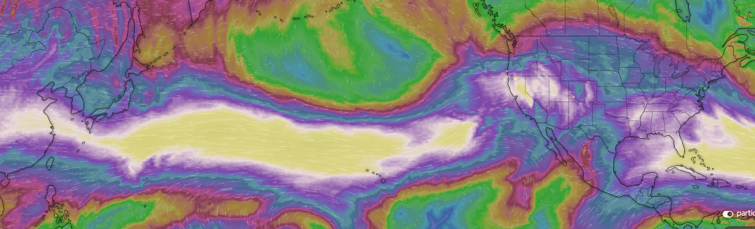
http://www.windy.com - The Atmospheric River - More on the way....

Today 7-8 Weather : 
Snow likely, mainly before 10am. Widespread blowing snow, mainly before 1pm. Mostly cloudy
Today 7-8 Wind Direction: 
SW
Today 8-9 Weather: 
Snow likely, mainly before 10am. Widespread blowing snow. Mostly cloudy, windy
Today 8-9 Wind Direction: 
SW
Tomorrow 7-8 Weather: 
Snow likely, mainly after 4pm. Partly sunny.
Tomorrow 7-8 Wind Direction: 
S
Tomorrow 8-9 Weather: 
Snow likely, mainly before 4pm. Partly sunny, windy
Tomorrow 8-9 Wind Direction: 
SW
Tonight 7-8 Weather: 
Partly cloudy
Tonight 7-8 Wind Direction: 
SW
Tonight 8-9 Weather: 
Partly cloudy, windy
Tonight 8-9 Wind Direction: 
W
Today 7-8 Temp: 
28
Today 8-9 Temp: 
17
Tomorrow 7-8 Temp: 
29
Tomorrow 8-9 Temp: 
18
Tonight 7-8 Temp: 
14
Tonight 8-9 Temp: 
3
25
19
26
23
153
13
0
18
15
23
19
190.9
12.9
0
Grey Butte Temp Cur: 
19
Grey Butte Temp Min: 
14
Grey Butte Temp Max: 
21.5
Grey Butte Temp Avg: 
18
Grey Butte Wind Cur: 
35
Grey Butte Wind Max: 
35
Grey Butte Wind Gust Max: 
61.34
Grey Butte Wind Avg: 
SSE
Castle Lake Temp Cur: 
28
Castle Lake Temp Min: 
25.5
Castle Lake Temp Max: 
28.5
Castle Lake Temp Avg: 
27.5
Mount Eddy Temp Cur: 
20.5
Mount Eddy Temp Min: 
18
Mount Eddy Temp Max: 
26
Mount Eddy Temp Avg: 
22
Mount Eddy Wind Cur: 
3
Mount Eddy Wind Max: 
4.5
Mount Eddy Wind Gust Max: 
7.61
Mount Eddy Wind Avg: 
SSW
Mount Eddy Snow Depth: 
159.9
Mount Eddy Snow New: 
11.9
Ash Creek Bowl Temp Cur: 
24
Ash Creek Bowl Temp Min: 
16.5
Ash Creek Bowl Temp Max: 
24
Ash Creek Bowl Temp Avg: 
20
Ash Creek Bowl Snow New: 
0
Ash Creek Ridge Temp Cur: 
16
Ash Creek Ridge Temp Min: 
13.5
Ash Creek Ridge Temp Max: 
21
Ash Creek Ridge Temp Avg: 
17
Ash Creek Ridge Wind Cur: 
1.5
Ash Creek Ridge Wind Max: 
68
Ash Creek Ridge Wind Gust Max: 
113.13
Mt. Shasta City Temp Cur: 
33
Mt. Shasta City Temp Min: 
30
Mt. Shasta City Temp Max: 
34
Mt. Shasta City Temp Avg: 
32
Mt. Shasta City Wind Cur: 
0
Mt. Shasta City Wind Min: 
0
Mt. Shasta City Wind Max: 
8
Mt. Shasta City Wind Avg: 
3
Ski Bowl Comments: 
Water content n/a
Grey Butte Wind Min: 
5.5
Grey Butte Wind Avg: 
16.5
Caslte Lake Comments: 
Snow depth sensor down
Mount Eddy Wind Min: 
1.5
Mount Eddy Wind Avg: 
3
Ash Creek Ridge Wind Min: 
0
Ash Creek Ridge Wind Avg: 
9.5
Sand Flat Snow Settlement: 
0
Ski Bowl Snow Settlement: 
0
Mount Eddy Snow Settlement: 
0
Ash Creek Bowl Snow Settlement: 
16.4
Measured Precipitation Oct: 
33.42
Normal Precipitation Oct: 
26.85
Percent Precipitation Oct: 
124
Measured Precipitation MTD: 
3.71
Normal Precipitation MTD: 
1.91
Percent Precipitation MTD: 
194
Measured Precipitation YTD: 
24.29
Normal Precipitation YTD: 
14.61
Percent Precipitation YTD: 
166
Today SWE: 
0.04
Tonight SWE: 
0.00
Tomorrow SWE: 
0.02
Today Wind Max 7-9: 
35
Tonight Wind Max 7-9: 
15
Tomorrow Wind Max 7-9: 
15
Today Wind Min 7-9: 
25
Tonight Wind Min 7-9: 
5
Tomorrow Wind Min 7-9: 
5
Today Wind Max 9-11: 
70
Tonight Wind Max 9-11: 
25
Tomorrow Wind Max 9-11: 
30
Today Wind Min 9-11: 
60
Tonight Wind Min 9-11: 
15
Tomorrow Wind Min 9-11: 
20
Today Snow Max 7-9: 
0.50
Tonight Snow Max 7-9: 
0.00
Tomorrow Snow Max 7-9: 
1.00
Today Snow Min 7-9: 
0.00
Tonight Snow Min 7-9: 
0.00
Tomorrow Snow Min 7-9: 
0.00
Today Snow Max 9-11: 
1.00
Tonight Snow Max 9-11: 
0.00
Tomorrow Snow Max 9-11: 
2.00
Today Snow Min 9-11: 
0.00
Tonight Snow Min 9-11: 
0.00
Tomorrow Snow Min 9-11: 
1.00
Ash Creek Bowl HS: 
158.3
Weather Station Discussion: 
The table below summarizes data reported from all of our weather stations over the last 24 hours.
Seasonal Stats Discussion: 
The wet season is October 1 through May 1. The table below summarizes recorded vs. normal precipitation amounts for the City of Mount Shasta.
Overall Danger Rating: 
High
Current Time: 
4:00 AM