Over the past 24 hours near treeline on Mt. Shasta:
- Temperature (°F): Min - 30 / Max - 43 / Mean - 37.5
- Wind (mi/hr): Current - 4 / Mean - 4 / Max - 25 / Direction - East
- Height of Snow: ~58 inches
West side of Interstate 5 / Eddy Mountains / Castle Lake:
- Temperature (°F): Min - 30 / Max - 46 / Mean - 37.5
- Wind (mi/hr): Current - 3 / Mean - 2 / Max - 7 / Direction - West/Southwest
- Height of Snow: ~35 inches
It's a rough and tumble situation out there right now, but that said, skiing and riding is still possible. Bring an arsenal of over snow travel skills. For climbers, conditions are decent. The mountain is not completely caked in snow, therefore rockfall is possible. Icefall has been less so, but still possible anywhere rime ice coats cliffs above. Not a lot to be said otherwise. Avalanches are a thing of the past lately, and the snowpack depth took a hit over the past weeks of warm weather. Temperatures will cool down next week, helping keep around what snow we have left. Windy conditions have littered much of the below treeline snowpack with debris of all sorts and has blown dirt all over the snowpack in some areas near and above treeline. I'll let the photos from our recent observations do the rest of the talking.
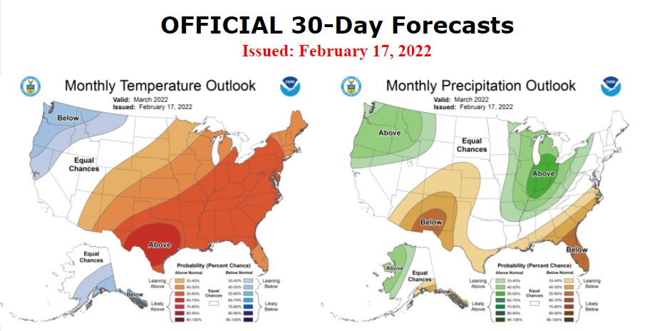
Clear and sunny today, temperatures expected to be a few degrees warmer than yesterday. Wind will be light. A low pressure trough will carve out a path for a larger trough to push a frontal system through the area Sunday and Monday. Moisture will be limited under the northwest flow, but there will be plenty of cold air spilling in. What precipitation we do receive will likely fall as snow. This is nothing to get the powder boards out for...at this point, models are predicting less than a tenth of an inch of precipitable water. Northwesterly wind will get turned up on Sunday, also. Until then, more big blue sky. Overall, the Climate Predication Center is indicating increased probabilities of a cooler and wetter than normal conditions for March. Um, yes please!