You are here

Forecast Addendum 1/12/2023 - 07:00am

Submitted by nmeyers on Thu, 01/12/2023 - 5:27am
Recent Observations: 

Yesterday was almost a carbon copy of the day prior...only the snow just keeps getting deeper. Really deep. Thigh to waist deep if you're not on some sort of flotation device, i.e. snowmobile, skis, snowshoes. The snow level hovered near 4,500 feet, with lower elevation flakes at times. Visibility was flat, near whiteout all day above treeline. Near steady precipitation brought an additional three to six inches of fresh snow. Two day storm total measured about 15 - 20 inches. Most accumulation occurred above 6,000 feet. Red flags of avalanche danger were subtle again below and near treeline. Fresh storm snow struggled to slab up, and I didn't see any snow behaving badly. As elevation was gained and wind more prevalent, slab properties improved. A careful "burb-the-baby" test highlighted a density weakness in the storm snow, 25 cm from the top of the snowpack. Column tests were unreactive. Wind above treeline was present, blowing out of the south/southeast and moving plenty of snow around. Areas with wind, near and above treeline, hosted the best slab properties and represented the highest avalanche risk for the day.

                                             Mount Shasta weather data round-up from the last 24 hours:

  • Total Height of Snow (treeline on Mount Shasta): 140 inches
  • New Snow: 3 - 6 inches
  • Snow/Water Equivalent: 1.07 inches
  • Wind: South - Min - 6 / Max - 36 / Avg - 10
  • Temp (°F): Min - 21 / Max - 29 / Avg - 25 


Mountain Weather: 

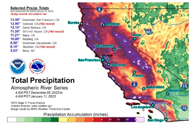
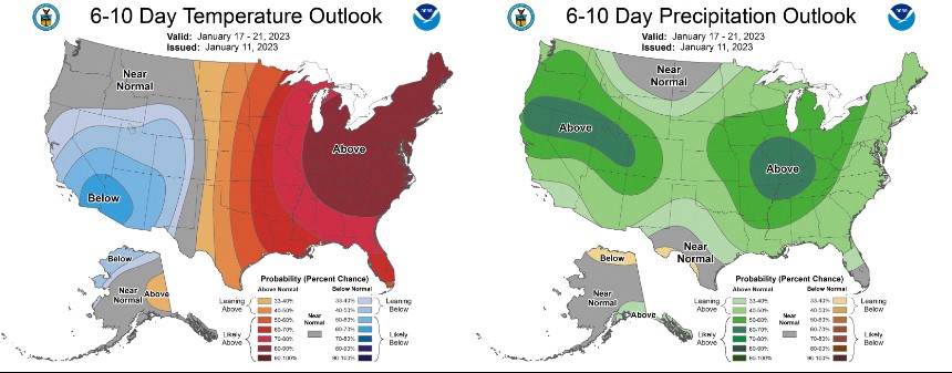
Compared to winter's of recent past, our weather has been baffling. A relentless advance of Pacific storms targeting California in the past week is forecast to shift focus and impact areas farther to the north. A large cyclone well off the West Coast will direct the atmospheric river in a more northerly course further up and parallel to the coast during the next couple of days. This will orient the threat of heavy precipitation from northern California northward along coastal Pacific Northwest through early Saturday, with northwestern California having the highest chance of excessive rainfall. This shift in the course of the atmospheric river is related to a change in the weather pattern across the U.S., allowing a ridge of high pressure to build over the western U.S. while a rather strong low pressure system moves swiftly through the eastern half of the country. While the strengthening ridge over the western U.S. will help keep moisture from moving much farther inland, it will also keep the heaviest precipitation locked in place across northern California to coastal Pacific Northwest. By Friday night, this pattern will show signs of breaking down, allowing the next Pacific cyclone to direct yet another surge of atmospheric river toward California by Saturday morning.

Today, a warm front has moved into the area and snow levels are rising. Gusty south winds have wind warnings in place for the Shasta Valley. Strong, gusty winds are expected through at least Friday evening. Precipitation will linger this morning and taper this afternoon. On Friday, another front will move inland. Additional fronts are expected Sunday through most of next week, but there is wide spread in the models.


Today 7-8 Weather : 
Snow before 1pm, then a chance of rain and snow. Snow could be heavy at times. Windy. Snow level 6,800 feet.
Today 7-8 Wind Direction: 
S
Today 8-9 Weather: 
Snow. The snow could be heavy at times. Windy
Today 8-9 Wind Direction: 
S
Tomorrow 7-8 Weather: 
Snow, heavy at times, windy. Snow level 5,500 feet
Tomorrow 7-8 Wind Direction: 
S
Tomorrow 8-9 Weather: 
Snow. The snow could be heavy at times. Windy
Tomorrow 8-9 Wind Direction: 
S
Tonight 7-8 Weather: 
A chance of rain and snow before 1am, then snow likely. Mostly cloudy, windy. Snow level 6,600 feet
Tonight 7-8 Wind Direction: 
S
Tonight 8-9 Weather: 
Snow likely, mainly after 4am. The snow could be heavy at times. Mostly cloudy
Tonight 8-9 Wind Direction: 
S
Today 7-8 Temp: 
32
Today 8-9 Temp: 
22
Tomorrow 7-8 Temp: 
33
Tomorrow 8-9 Temp: 
22
Tonight 7-8 Temp: 
32
Tonight 8-9 Temp: 
22
27
26
28
27
83
14
0
28.5
21.5
28.5
24.5
140.3
3.5
1.05
Grey Butte Temp Cur: 
27
Grey Butte Temp Min: 
20.5
Grey Butte Temp Max: 
27
Grey Butte Temp Avg: 
23.5
Grey Butte Wind Cur: 
16
Grey Butte Wind Max: 
16
Grey Butte Wind Gust Max: 
30.66
Grey Butte Wind Avg: 
S
Castle Lake Temp Cur: 
33.5
Castle Lake Temp Min: 
29
Castle Lake Temp Max: 
33.5
Castle Lake Temp Avg: 
30.5
Mount Eddy Temp Cur: 
31.5
Mount Eddy Temp Min: 
24.5
Mount Eddy Temp Max: 
31.5
Mount Eddy Temp Avg: 
27.5
Mount Eddy Wind Cur: 
2.5
Mount Eddy Wind Max: 
3
Mount Eddy Wind Gust Max: 
5.74
Mount Eddy Wind Avg: 
SSW
Mount Eddy Snow Depth: 
110.4
Mount Eddy Snow New: 
4.2
Ash Creek Bowl Temp Cur: 
25
Ash Creek Bowl Temp Min: 
23
Ash Creek Bowl Temp Max: 
25
Ash Creek Bowl Temp Avg: 
23.5
Ash Creek Ridge Temp Cur: 
26.5
Ash Creek Ridge Temp Min: 
19.5
Ash Creek Ridge Temp Max: 
26.5
Ash Creek Ridge Temp Avg: 
22
Ash Creek Ridge Wind Cur: 
0
Ash Creek Ridge Wind Max: 
0
Ash Creek Ridge Wind Gust Max: 
0
Mt. Shasta City Temp Cur: 
40
Mt. Shasta City Temp Min: 
33
Mt. Shasta City Temp Max: 
40
Mt. Shasta City Temp Avg: 
36
Mt. Shasta City Wind Cur: 
7
Mt. Shasta City Wind Min: 
0
Mt. Shasta City Wind Max: 
8
Mt. Shasta City Wind Avg: 
4
Mt. Shasta City Wind Avg: 
ESE
Sand Flat Comments: 
Not responding
Grey Butte Wind Min: 
6.5
Grey Butte Wind Avg: 
9.5
Caslte Lake Comments: 
snow depth sensor down
Mount Eddy Wind Min: 
1.5
Mount Eddy Wind Avg: 
2
Ash Creek Bowl Comments: 
Not responding
Ash Creek Ridge Wind Min: 
0
Ash Creek Ridge Wind Avg: 
0
Sand Flat Snow Settlement: 
0
Ski Bowl Snow Settlement: 
0
Mount Eddy Snow Settlement: 
0
Measured Precipitation Oct: 
21.16
Normal Precipitation Oct: 
14.6
Percent Precipitation Oct: 
145
Measured Precipitation MTD: 
12.03
Normal Precipitation MTD: 
2.36
Percent Precipitation MTD: 
510
Measured Precipitation YTD: 
12.03
Normal Precipitation YTD: 
2.36
Percent Precipitation YTD: 
510
Today SWE: 
0.45
Tonight SWE: 
0.06
Tomorrow SWE: 
0.67
Today Wind Max 7-9: 
40
Tonight Wind Max 7-9: 
35
Tomorrow Wind Max 7-9: 
40
Today Wind Min 7-9: 
30
Tonight Wind Min 7-9: 
25
Tomorrow Wind Min 7-9: 
30
Today Wind Max 9-11: 
60
Tonight Wind Max 9-11: 
70
Tomorrow Wind Max 9-11: 
75
Today Wind Min 9-11: 
50
Tonight Wind Min 9-11: 
60
Tomorrow Wind Min 9-11: 
65
Today Snow Max 7-9: 
5.00
Tonight Snow Max 7-9: 
2.00
Tomorrow Snow Max 7-9: 
8.00
Today Snow Min 7-9: 
3.00
Tonight Snow Min 7-9: 
1.00
Tomorrow Snow Min 7-9: 
4.00
Today Snow Max 9-11: 
7.00
Tonight Snow Max 9-11: 
5.00
Tomorrow Snow Max 9-11: 
9.00
Today Snow Min 9-11: 
5.00
Tonight Snow Min 9-11: 
3.00
Tomorrow Snow Min 9-11: 
6.00
Weather Station Discussion: 
The table below summarizes data reported from all of our weather stations over the last 24 hours.
Seasonal Stats Discussion: 
The wet season is October 1 through May 1. The table below summarizes recorded vs. normal precipitation amounts for the City of Mount Shasta.
Overall Danger Rating: 
Considerable
Current Time: 
3:00 AM