Submitted by nmeyers on Fri, 01/13/2023 - 5:12am
Recent Observations:
Yesterday was a widespread, total meltdown. Rain on fresh snow occurred at least to 8,000 feet. Not a flake of snow fell from the sky below and near treeline. Frosty snow and rime plastered trees turned into a winter rain forest. Heavy, snow crusted tree tops, big and small, snapped off and scattered in many areas below and near treeline. Gale force winds have cranked out of the south/southeast. Tree bombs pounded the snowpack. A misty rain fell sideways. It was a constant state of mist for most of the day. We were IN the clouds. The top 15 cm of the snowpack was saturated and ultra gloppy. Below, dryer storm snow remains. It was the ultimate upside down cake. We did not see any avalanche debris, but visibility and wet, deep snow travel was difficult. The main red flag of the day was rain on fresh snow and strong wind. We stuck to low angle terrain. Temperatures have cooled off this morning and a crust of some sort is likely today, the next bed surface for the new snow expected. Three inches of new snow fell overnight. Deep rain runnels have formed below ~6,500 feet. Some tree wells are 4–6 feet deep. Boot penetration is thigh to waist deep in heavy, wet, nasty...snow. Temperatures reached their zenith at 1400 hours yesterday. On Gray Butte and Old Ski Bowl, temps climbed to 32° F, and on the west side, 34° F and 36° F at Mt Eddy and Castle Lake stations, respectively.
Mountain Weather:
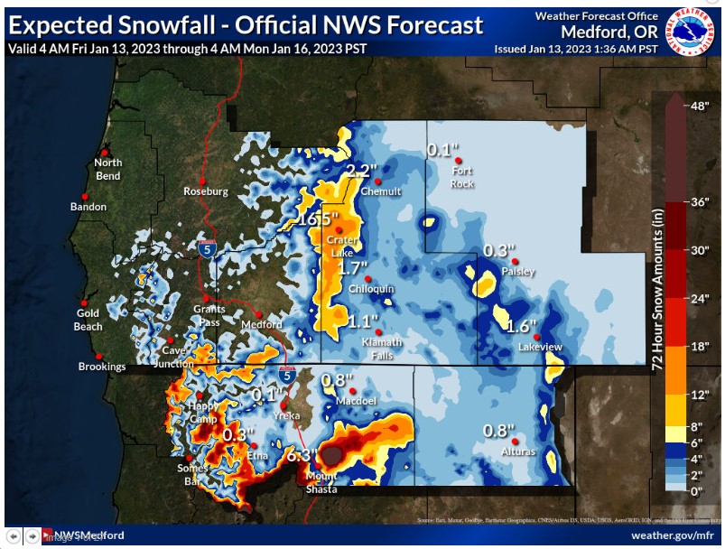
The ongoing, unsettled weather in the West associated with the active atmospheric river pattern continues into this weekend, with another couple rounds of heavy precipitation in the forecast. Rain and high elevation mountain snow is ongoing this morning, though relatively lighter compared to other recent storms. A more intense surge of moisture is expected on Saturday. Temperatures will cool down gradually today and into tonight. Today, snow levels will initially be high, around 6,000 to 6,500 feet this morning, lowering to 5,000 to 5,500 feet this afternoon into this evening. Heavy precipitation is possible at times above 5,000 feet. Gusty winds will occur across the area, and high wind warnings are in place for the Shasta Valley. Another potent low pressure system will move into the area Saturday, with additional precipitation and gusty winds. Showers will linger Sunday.
Today 7-8 Weather :
Snow, heavy at times, temperature falling to 28 by 1pm, windy
Today 7-8 Wind Direction:
S
Today 8-9 Weather:
Snow, heavy at times, temperature falling to 17 by 4pm, windy
Today 8-9 Wind Direction:
S
Tomorrow 7-8 Weather:
Snow, heavy at times, windy
Tomorrow 7-8 Wind Direction:
S
Tomorrow 8-9 Weather:
Snow, heavy at times, windy
Tomorrow 8-9 Wind Direction:
S
Tonight 7-8 Weather:
Snow, heavy at times, breezy
Tonight 7-8 Wind Direction:
S
Tonight 8-9 Weather:
Snow, heavy at times, windy
Tonight 8-9 Wind Direction:
SW
32
32
33
33
101
0
0
28.5
28
32
31
139.7
0
0.82
Grey Butte Temp Cur:
27.5
Grey Butte Temp Min:
27.5
Grey Butte Temp Avg:
30.5
Grey Butte Wind Gust Max:
42.93
Castle Lake Temp Cur:
34.5
Castle Lake Temp Min:
33.5
Castle Lake Temp Max:
36.5
Castle Lake Temp Avg:
35.5
Mount Eddy Temp Cur:
30.5
Mount Eddy Temp Max:
34.5
Mount Eddy Wind Gust Max:
9.63
Mount Eddy Snow Depth:
107.4
Ash Creek Bowl Temp Cur:
25
Ash Creek Bowl Temp Min:
23
Ash Creek Bowl Temp Max:
25
Ash Creek Bowl Temp Avg:
23.5
Ash Creek Ridge Temp Cur:
26.5
Ash Creek Ridge Temp Min:
26.5
Ash Creek Ridge Temp Max:
31
Ash Creek Ridge Temp Avg:
29
Ash Creek Ridge Wind Cur:
0
Ash Creek Ridge Wind Max:
0
Ash Creek Ridge Wind Gust Max:
0
Mt. Shasta City Temp Cur:
42
Mt. Shasta City Temp Min:
41
Mt. Shasta City Temp Max:
45
Mt. Shasta City Temp Avg:
43
Mt. Shasta City Wind Cur:
4
Mt. Shasta City Wind Min:
3
Mt. Shasta City Wind Max:
7
Mt. Shasta City Wind Avg:
5
Mt. Shasta City Wind Avg:
ESE
Grey Butte Wind Min:
11.5
Grey Butte Wind Avg:
14.5
Ash Creek Ridge Wind Min:
0
Ash Creek Ridge Wind Avg:
0
Sand Flat Snow Settlement:
4
Ski Bowl Snow Settlement:
2
Mount Eddy Snow Settlement:
3.3
Measured Precipitation Oct:
21.77
Normal Precipitation Oct:
14.81
Percent Precipitation Oct:
147
Measured Precipitation MTD:
12.64
Normal Precipitation MTD:
2.57
Percent Precipitation MTD:
492
Measured Precipitation YTD:
12.64
Normal Precipitation YTD:
2.57
Percent Precipitation YTD:
492
Tomorrow Wind Max 7-9:
30
Tomorrow Wind Min 7-9:
20
Tonight Wind Max 9-11:
55
Tomorrow Wind Max 9-11:
65
Tonight Wind Min 9-11:
45
Tomorrow Wind Min 9-11:
55
Tonight Snow Max 7-9:
10.00
Tomorrow Snow Max 7-9:
10.00
Tonight Snow Min 7-9:
5.00
Tomorrow Snow Min 7-9:
4.00
Today Snow Max 9-11:
10.00
Tonight Snow Max 9-11:
12.00
Tomorrow Snow Max 9-11:
12.00
Today Snow Min 9-11:
7.00
Tonight Snow Min 9-11:
7.00
Tomorrow Snow Min 9-11:
6.00
Weather Station Discussion:
The table below summarizes data reported from all of our weather stations over the last 24 hours.
Seasonal Stats Discussion:
The wet season is October 1 through May 1. The table below summarizes recorded vs. normal precipitation amounts for the City of Mount Shasta.
Overall Danger Rating:
High


