You are here

Forecast Addendum 1/13/2023 - 07:00am

Submitted by nmeyers on Sun, 01/15/2023 - 5:26am
Recent Observations: 

The culmination of nearly three weeks of being blasted by the great Pacific fire hose is upon us. It's been a roller-coaster of emotions, from deep powder transcendental elation to soul crushing rain on snow events...and everything in between. Nearing the end, I have few words other than, unbelievable.

Yesterday was impressive. Nearly constant snowfall occurred during daylight hours. Snow levels hovered around 4,000 feet with wild fluctuations +/- 1,500 feet at times. The heaviest snowfall occurred during the AM hours, with a three-hour period of 2–3 inches per hour of snow accumulation, equalling .68" of water. Snow totals since the January 12th meltdown average 2–3 feet above 6,000 feet. If there ever was a time to use the word snowpocalypse, now is good. Near treeline on Mount Shasta, 13.5 feet is on the ground.

We have not seen any recent avalanches. Visibility and access has been very difficult, and we've been sticking to low angle terrain. That said, plenty of red flags of avalanche danger were flying yesterday including whumpfing, cracking wind slabs, recent heavy snow, moderate to strong SSE wind and easy ski cut storm slabs on small test slopes. Near the end of the day, storm snow consistency became moist and began to show signs of rapid settlement. Settlement cracks starting to show around trees. The temperature trend is cooling.

In the pit, west facing / 7,800 feet near treeline) extended column tests highlighted a couple weak layers within the two-day (1/13 and 1/14) storm snow, at 15 and 80 cm down. Soft, shallow storm slabs below and near treeline and areas that have been affected by the wind near and above treeline had the best slab characteristics and represented the main hazard focus for the day. Cornices along ridges are becoming large. At the end of the day, a donut hole of blue sky opened up for about 20 minutes, and then was gone.      


Mountain Weather: 

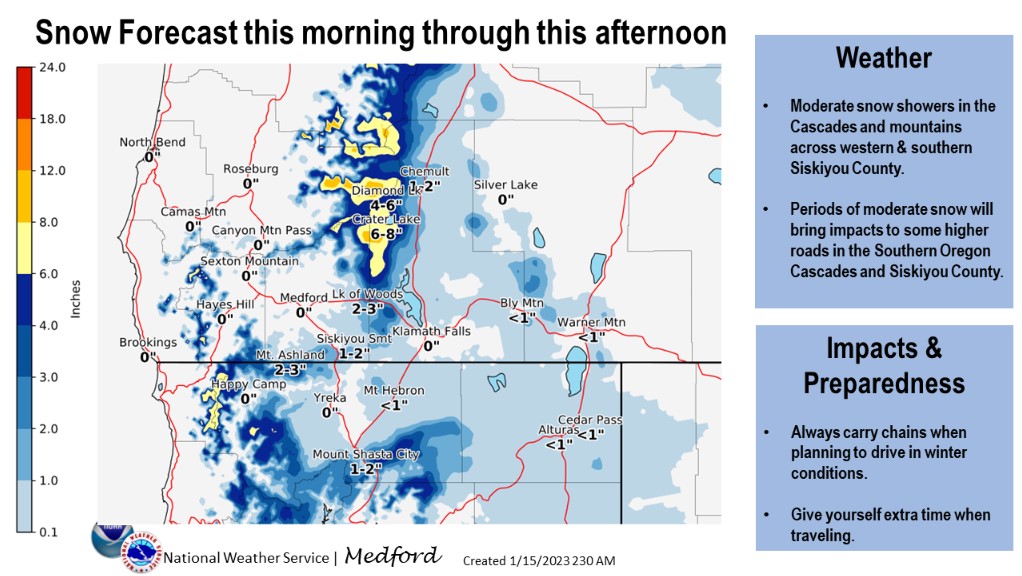
This weekend seems to be the grand finale of weather, for a show that started back in late December. In the past 3 weeks, the Old Ski Bowl weather station recorded 111 inches of snow accumulation, equalling 18.75 inches of water. A grand finale it is, with 2-3 feet just since our January 12th rain on snow meltdown. Today, showery activity has been slow to move on shore, but models indicate that numerous showers will spread inland this morning with moderate intensity. Snow levels are expected to remain near 3,500 feet. A winter weather advisory has been issued by the NWS for this morning until 8AM, above 4,000 feet. Gusty southwest winds are also likely over higher terrain. Shower activity will gradually decrease this evening and tonight. Expect cool conditions Monday. We will see an overall transition in the weather pattern for the extended period. Over the recent weeks, we've been under persistent south/southwest flow, which leads to enhanced precipitation for Siskiyou County and dryer down sloping affect for southern Oregon. Northwest flow will take over soon, and this pattern favors lower snow levels with less down sloping affect. Precipitation is usually more widespread across southern Oregon and more limited to northern California. An extended break in the active weather will ensue.

Today 7-8 Weather : 
Snow showers likely, cloudy, snow level near 3,400 feet
Today 7-8 Wind Direction: 
S
Today 8-9 Weather: 
Snow, cloudy, windy
Today 8-9 Wind Direction: 
SW
Tomorrow 7-8 Weather: 
Partly cloudy
Tomorrow 7-8 Wind Direction: 
N
Tomorrow 8-9 Weather: 
Chance of snow, mostly cloudy
Tomorrow 8-9 Wind Direction: 
W
Tonight 7-8 Weather: 
Chance of snow showers, mostly cloudy
Tonight 7-8 Wind Direction: 
S
Tonight 8-9 Weather: 
Chance of snow showers, mostly cloudy
Tonight 8-9 Wind Direction: 
W
Today 7-8 Temp: 
25
Today 8-9 Temp: 
11
Tomorrow 7-8 Temp: 
27
Tomorrow 8-9 Temp: 
13
Tonight 7-8 Temp: 
19
Tonight 8-9 Temp: 
9
25
23
32
28
121
6
0
20.5
18
27.5
23.5
159.5
11
1.62
Grey Butte Temp Cur: 
19
Grey Butte Temp Min: 
19
Grey Butte Temp Max: 
26
Grey Butte Temp Avg: 
23.5
Grey Butte Wind Cur: 
13
Grey Butte Wind Max: 
19.5
Grey Butte Wind Gust Max: 
42.93
Grey Butte Wind Avg: 
SSE
Castle Lake Temp Cur: 
28
Castle Lake Temp Min: 
27.5
Castle Lake Temp Max: 
33
Castle Lake Temp Avg: 
30.5
Mount Eddy Temp Cur: 
24
Mount Eddy Temp Min: 
24
Mount Eddy Temp Max: 
30
Mount Eddy Temp Avg: 
27.5
Mount Eddy Wind Cur: 
0
Mount Eddy Wind Max: 
0
Mount Eddy Wind Gust Max: 
0
Mount Eddy Snow Depth: 
129.8
Mount Eddy Snow New: 
15
Ash Creek Bowl Temp Cur: 
21.5
Ash Creek Bowl Temp Min: 
20
Ash Creek Bowl Temp Max: 
27
Ash Creek Bowl Temp Avg: 
24.5
Ash Creek Bowl Snow New: 
8
Ash Creek Ridge Temp Cur: 
18
Ash Creek Ridge Temp Min: 
17
Ash Creek Ridge Temp Max: 
24
Ash Creek Ridge Temp Avg: 
21.5
Ash Creek Ridge Wind Cur: 
0
Ash Creek Ridge Wind Max: 
0
Ash Creek Ridge Wind Gust Max: 
0
Mt. Shasta City Temp Cur: 
35
Mt. Shasta City Temp Min: 
35
Mt. Shasta City Temp Max: 
42
Mt. Shasta City Temp Avg: 
38
Mt. Shasta City Wind Cur: 
4
Mt. Shasta City Wind Min: 
0
Mt. Shasta City Wind Max: 
8
Mt. Shasta City Wind Avg: 
3
Mt. Shasta City Wind Avg: 
ESE
Sand Flat Comments: 
Not responding
Grey Butte Wind Min: 
9.5
Grey Butte Wind Avg: 
13
Caslte Lake Comments: 
snow depth sensor down
Mount Eddy Wind Min: 
0
Mount Eddy Wind Avg: 
0
Ash Creek Ridge Wind Min: 
0
Ash Creek Ridge Wind Avg: 
0
Sand Flat Snow Settlement: 
0
Ski Bowl Snow Settlement: 
4
Mount Eddy Snow Settlement: 
0
Measured Precipitation Oct: 
25.49
Normal Precipitation Oct: 
15.21
Percent Precipitation Oct: 
168
Measured Precipitation MTD: 
16.36
Normal Precipitation MTD: 
2.97
Percent Precipitation MTD: 
551
Measured Precipitation YTD: 
16.36
Normal Precipitation YTD: 
2.97
Percent Precipitation YTD: 
551
Today SWE: 
0.09
Tonight SWE: 
0.12
Tomorrow SWE: 
0.00
Today Wind Max 7-9: 
20
Tonight Wind Max 7-9: 
15
Tomorrow Wind Max 7-9: 
15
Today Wind Min 7-9: 
10
Tonight Wind Min 7-9: 
5
Tomorrow Wind Min 7-9: 
5
Today Wind Max 9-11: 
35
Tonight Wind Max 9-11: 
20
Tomorrow Wind Max 9-11: 
10
Today Wind Min 9-11: 
25
Tonight Wind Min 9-11: 
10
Tomorrow Wind Min 9-11: 
5
Today Snow Max 7-9: 
5.00
Tonight Snow Max 7-9: 
3.00
Tomorrow Snow Max 7-9: 
0.50
Today Snow Min 7-9: 
3.00
Tonight Snow Min 7-9: 
1.00
Tomorrow Snow Min 7-9: 
0.00
Today Snow Max 9-11: 
5.00
Tonight Snow Max 9-11: 
2.00
Tomorrow Snow Max 9-11: 
5.00
Today Snow Min 9-11: 
3.00
Tonight Snow Min 9-11: 
1.00
Tomorrow Snow Min 9-11: 
0.00
Ash Creek Bowl HS: 
160
Weather Station Discussion: 
The table below summarizes data reported from all of our weather stations over the last 24 hours.
Seasonal Stats Discussion: 
The wet season is October 1 through May 1. The table below summarizes recorded vs. normal precipitation amounts for the City of Mount Shasta.
Overall Danger Rating: 
Considerable
Current Time: 
3:00 AM