Submitted by efalconer on Wed, 01/18/2023 - 5:59am
Recent Observations:
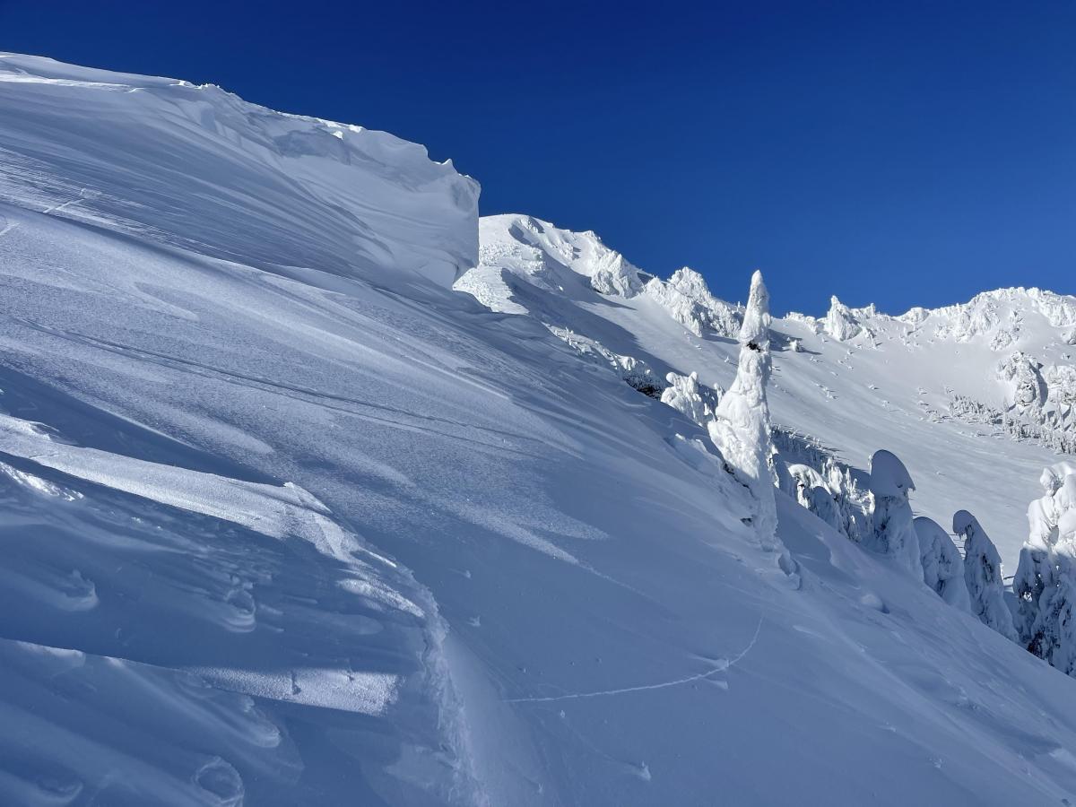
The takeaways over the last few days include a strong wind shift to the north, which has loaded southerly aspects during the daylight hours of the 16th and 17th out near Ash Creek Butte. These winds were not as pronounced on the south side of Mount Shasta, which is a good reminder that other areas in the forecast zone can present different pictures. Yesterday, in the Eddies, I found a surface hoar layer covering east and northeast aspects near and above treeline. Impressively large cornices can be seen looming along ridgelines near and above the treeline, indicating the slopes below them hold a large amount of wind-loaded snow. On east and west slopes near treeline, a sneaky layer of weak snow 90 cm to 55 cm below the surface has been propagating in stability test on the 23rd tap. This layer may be stubborn and need a large load to trigger. Nevertheless, the recipe for an avalanche does exist and would have deadly consequences. Stark signs of the snowpack settlement below and near the treeline include cracking below cornices, snow gaps near ridgelines, and tenting around tree trunks.
Mountain Weather:
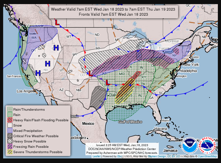
A winter weather advisory has been issued above 2,500 ft from 4am to 10pm today. A storm system will track NW to SE across the region, delivering gusty winds and periods of heavy precipitation during the daylight hours. The snow level will hang around 3,000 ft, but could drop as low as 1,500 ft. Today's winds will start out from the south and shift to the northwest by nightfall. Wind speeds will be in the upper teens, with gusts near 40 mph. Freezing levels will stay in place above 3,500 ft today and dropping to near 2, 500 ft by tonight.
Today 7-8 Weather :
Snow, mainly after 10am. The snow could be heavy at times. High near 26. Breezy, with a south wind 13 to 18 mph increasing to 19 to 24 mph in the afternoon. Winds could gust as high as 37 mph. Chance of precipitation is 100%. New snow accumulation of 3 to 7 inches possible. Freezing level near 3,300 ft
Today 7-8 Wind Direction:
S
Today 8-9 Weather:
Snow, mainly after 10am. The snow could be heavy at times. High near 18. Wind chill values as low as -14. Chance of precipitation is 90%. New snow accumulation of 4 to 8 inches possible
Today 8-9 Wind Direction:
SW
Tomorrow 7-8 Weather:
Mostly sunny, with a high near 25. North northwest wind 8 to 13 mph, with gusts as high as 20 mp. Freezing level near 2, 500 ft
Tomorrow 7-8 Wind Direction:
N
Tomorrow 8-9 Weather:
Mostly sunny, with a high near 14. Wind chill values as low as -15.
Tomorrow 8-9 Wind Direction:
N
Tonight 7-8 Weather:
Snow before 7pm, then snow showers between 7pm and 10pm. Low around 16. North wind 13 to 15 mph, with gusts as high as 23 mph. Freezing level near 2,100 ft
Tonight 7-8 Wind Direction:
NW
Tonight 8-9 Weather:
Snow before 7pm, then snow showers between 7pm and 10pm. Low around 2. Wind chill values as low as -16. Chance of precipitation is 90%. New snow accumulation of around an inch possible
Tonight 8-9 Wind Direction:
NW
15
9
30
19
115
0
0
12
11.5
30
17
152.2
0
0
Grey Butte Temp Avg:
20.5
Grey Butte Wind Gust Max:
24.54
Castle Lake Temp Cur:
26.5
Castle Lake Temp Max:
29.5
Castle Lake Temp Avg:
25.5
Mount Eddy Temp Cur:
20.5
Mount Eddy Temp Max:
27.5
Mount Eddy Wind Gust Max:
0
Mount Eddy Snow Depth:
117.5
Ash Creek Bowl Temp Cur:
20
Ash Creek Bowl Temp Min:
13
Ash Creek Bowl Temp Max:
25.5
Ash Creek Bowl Temp Avg:
18.5
Ash Creek Bowl Snow New:
16.4
Ash Creek Ridge Temp Cur:
19
Ash Creek Ridge Temp Min:
12.5
Ash Creek Ridge Temp Max:
22
Ash Creek Ridge Temp Avg:
17
Ash Creek Ridge Wind Cur:
0
Ash Creek Ridge Wind Max:
0
Ash Creek Ridge Wind Gust Max:
0
Mt. Shasta City Temp Cur:
27
Mt. Shasta City Temp Min:
27
Mt. Shasta City Temp Max:
41
Mt. Shasta City Temp Avg:
32.5
Mt. Shasta City Wind Cur:
0
Mt. Shasta City Wind Min:
0
Mt. Shasta City Wind Max:
4
Mt. Shasta City Wind Avg:
1
Mt. Shasta City Wind Avg:
N
Ash Creek Ridge Wind Min:
0
Ash Creek Ridge Wind Avg:
0
Sand Flat Snow Settlement:
3
Ski Bowl Snow Settlement:
4.2
Mount Eddy Snow Settlement:
2.8
Ash Creek Bowl Snow Settlement:
0
Measured Precipitation Oct:
25.62
Normal Precipitation Oct:
15.59
Percent Precipitation Oct:
164
Measured Precipitation MTD:
16.49
Normal Precipitation MTD:
3.35
Percent Precipitation MTD:
492
Measured Precipitation YTD:
16.49
Normal Precipitation YTD:
3.35
Percent Precipitation YTD:
492
Tomorrow Wind Max 7-9:
25
Tonight Wind Max 9-11:
15
Tomorrow Wind Max 9-11:
20
Tomorrow Wind Min 9-11:
10
Tonight Snow Max 7-9:
3.00
Tomorrow Snow Max 7-9:
0.50
Tonight Snow Min 7-9:
1.00
Tomorrow Snow Min 7-9:
0.00
Today Snow Max 9-11:
5.00
Tonight Snow Max 9-11:
2.00
Tomorrow Snow Max 9-11:
5.00
Today Snow Min 9-11:
3.00
Tonight Snow Min 9-11:
1.00
Tomorrow Snow Min 9-11:
0.00
Weather Station Discussion:
The table below summarizes data reported from all of our weather stations over the last 24 hours.
Seasonal Stats Discussion:
The wet season is October 1 through May 1. The table below summarizes recorded vs. normal precipitation amounts for the City of Mount Shasta.
Overall Danger Rating:
Considerable


