You are here

Forecast Addendum 1/21/2023 - 07:00am

Submitted by nmeyers on Sat, 01/21/2023 - 5:13am
Recent Observations: 

A gorgeous day on Mount Shasta yesterday. Access via the Everitt Memorial Highway and Castle Lake roads is still closed. Siskiyou County is working to open the roads as soon as possible. The struggle remains with equipment breaking down and very deep snow. A 16-foot drift exists at Windy Point, just below Bunny Flat. 

Red flags of avalanche danger across the forecast area have been hard to come by. Snow from the incessant storms during the first few weeks of January has settled out nicely. Snow surfaces below and near treeline remain smooth and soft. A few sun crusts are beginning to form on sunny aspects. Surface hoar is widespread in low-lying areas. Snow and rime plastered trees started to unload yesterday, mid-afternoon. Above treeline, the recent north wind has done a number on the snowpack. Widespread wind textured snow dominates. While plenty of wind slabs exist on the landscape, slabs have been unreactive to trigger. Yesterday, the wind was light at 10,000 feet on Green Butte Ridge. Overall, Mount Shasta is completely plastered in snow and rime and looking quite beautiful! In the last 24 hours, temperatures have ranged from 13° to 31° F. Wind has blown primarily out of the WNW and ENE, averaging 7 mi/hr with gusts to 36 mi/hr. Snow on the ground near treeline measures ~147 inches. 


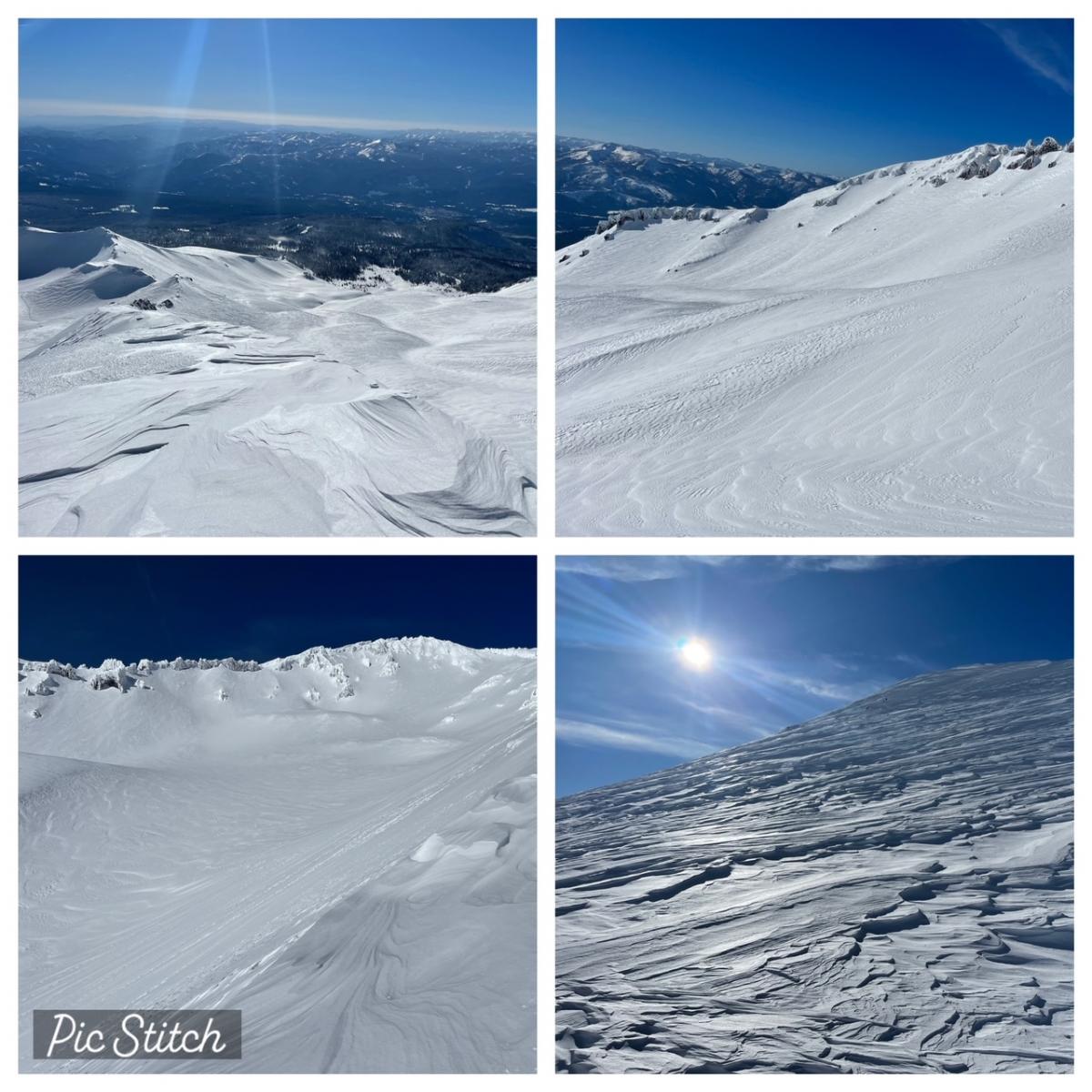
Clockwise from top left: 10k ft on Green Butte Ridge looking south / Avalanche Gulch, 50/50 Flat, Casaval Ridge / Widespread wind textured snow above treeline / Upper Avalanche Gulch  [Photos: N Meyers on 01.20.23]


Mountain Weather: 

The current satellite shows clear skies over most of the region, with fog persisting in some of the valleys. A cold front is visible offshore and will arrive later this morning, but the bulk of the precipitation will be well to the north. Wind out of the north to northwest wind will pick up later today. Increased mixing from the front will help clear out low clouds and valley fog, and daytime highs will be a bit warmer. Our weather pattern in the longer term will be dominated by a high pressure ridge, centered far offshore. With a persistent ridge, there is a potential for stagnant air in the valleys. Night and morning valley low clouds will be a daily occurrence. Otherwise, expect the skies to be clear. Longer term, there is considerable uncertainty in whether we will be in a northerly, westerly or southwesterly flow pattern. In either of the three cases, we would likely see only a modest increase in weather activity.


Today 7-8 Weather : 
Sunny
Today 7-8 Wind Direction: 
N
Today 8-9 Weather: 
Sunny, windy
Today 8-9 Wind Direction: 
NW
Tomorrow 7-8 Weather: 
Sunny, windy
Tomorrow 7-8 Wind Direction: 
N
Tomorrow 8-9 Weather: 
Sunny, windy
Tomorrow 8-9 Wind Direction: 
N
Tonight 7-8 Weather: 
Partly cloudy, windy
Tonight 7-8 Wind Direction: 
NW
Tonight 8-9 Weather: 
Partly cloudy, windy
Tonight 8-9 Wind Direction: 
NW
Today 7-8 Temp: 
37
Today 8-9 Temp: 
27
Tomorrow 7-8 Temp: 
27
Tomorrow 8-9 Temp: 
16
Tonight 7-8 Temp: 
19
Tonight 8-9 Temp: 
11
22
7
29
17
112
0
0
19
19
23
21.5
147.9
0
0
Grey Butte Temp Cur: 
27
Grey Butte Temp Min: 
13
Grey Butte Temp Max: 
31.5
Grey Butte Temp Avg: 
22.5
Grey Butte Wind Cur: 
8
Grey Butte Wind Max: 
13.5
Grey Butte Wind Gust Max: 
36.8
Grey Butte Wind Avg: 
ENE
Castle Lake Temp Cur: 
27.5
Castle Lake Temp Min: 
18
Castle Lake Temp Max: 
27.5
Castle Lake Temp Avg: 
23.5
Mount Eddy Temp Cur: 
25
Mount Eddy Temp Min: 
19.5
Mount Eddy Temp Max: 
30.5
Mount Eddy Temp Avg: 
24
Mount Eddy Wind Cur: 
3
Mount Eddy Wind Max: 
3.5
Mount Eddy Wind Gust Max: 
5.48
Mount Eddy Wind Avg: 
WSW
Mount Eddy Snow Depth: 
113.9
Mount Eddy Snow New: 
0
Ash Creek Bowl Temp Cur: 
23
Ash Creek Bowl Temp Min: 
12.5
Ash Creek Bowl Temp Max: 
23.5
Ash Creek Bowl Temp Avg: 
18.5
Ash Creek Bowl Snow New: 
0
Ash Creek Ridge Temp Cur: 
19.5
Ash Creek Ridge Temp Min: 
8
Ash Creek Ridge Temp Max: 
19.5
Ash Creek Ridge Temp Avg: 
14.5
Ash Creek Ridge Wind Cur: 
0
Ash Creek Ridge Wind Max: 
0
Ash Creek Ridge Wind Gust Max: 
0
Mt. Shasta City Temp Cur: 
20
Mt. Shasta City Temp Min: 
20
Mt. Shasta City Temp Max: 
40
Mt. Shasta City Temp Avg: 
28.5
Mt. Shasta City Wind Cur: 
3
Mt. Shasta City Wind Min: 
0
Mt. Shasta City Wind Max: 
4
Mt. Shasta City Wind Avg: 
1
Mt. Shasta City Wind Avg: 
N
Sand Flat Comments: 
Not responding
Ski Bowl Comments: 
Not responding
Grey Butte Wind Min: 
0.5
Grey Butte Wind Avg: 
5.5
Caslte Lake Comments: 
snow depth sensor down
Mount Eddy Wind Min: 
0
Mount Eddy Wind Avg: 
2
Ash Creek Ridge Wind Min: 
0
Ash Creek Ridge Wind Avg: 
0
Sand Flat Snow Settlement: 
1
Ski Bowl Snow Settlement: 
0
Mount Eddy Snow Settlement: 
2.1
Ash Creek Bowl Snow Settlement: 
17
Measured Precipitation Oct: 
25.88
Normal Precipitation Oct: 
16.32
Percent Precipitation Oct: 
159
Measured Precipitation MTD: 
16.75
Normal Precipitation MTD: 
4.08
Percent Precipitation MTD: 
411
Measured Precipitation YTD: 
16.75
Normal Precipitation YTD: 
4.08
Percent Precipitation YTD: 
411
Today SWE: 
0.00
Tonight SWE: 
0.00
Tomorrow SWE: 
0.00
Today Wind Max 7-9: 
10
Tonight Wind Max 7-9: 
15
Tomorrow Wind Max 7-9: 
15
Today Wind Min 7-9: 
5
Tonight Wind Min 7-9: 
10
Tomorrow Wind Min 7-9: 
10
Today Wind Max 9-11: 
25
Tonight Wind Max 9-11: 
70
Tomorrow Wind Max 9-11: 
80
Today Wind Min 9-11: 
15
Tonight Wind Min 9-11: 
60
Tomorrow Wind Min 9-11: 
70
Today Snow Max 7-9: 
0.00
Tonight Snow Max 7-9: 
0.00
Tomorrow Snow Max 7-9: 
0.00
Today Snow Min 7-9: 
0.00
Tonight Snow Min 7-9: 
0.00
Tomorrow Snow Min 7-9: 
0.00
Today Snow Max 9-11: 
0.00
Tonight Snow Max 9-11: 
0.00
Tomorrow Snow Max 9-11: 
0.00
Today Snow Min 9-11: 
0.00
Tonight Snow Min 9-11: 
0.00
Tomorrow Snow Min 9-11: 
0.00
Ash Creek Bowl HS: 
126.1
Weather Station Discussion: 
The table below summarizes data reported from all of our weather stations over the last 24 hours.
Seasonal Stats Discussion: 
The wet season is October 1 through May 1. The table below summarizes recorded vs. normal precipitation amounts for the City of Mount Shasta.
Overall Danger Rating: 
Moderate
Current Time: 
4:00 AM