

It's on out there, but not game on. Overall height of snow on Mount Shasta and east of the mountain averages ~50-60 inches. Over on the west side, snow depths are less, averaging ~40 inches. Whacking an earthy object is still possible, but chances are becoming less so, especially as recent storm snow sets up. No precipitation has fallen from the sky since last weekend (12-11-22), so expect some snow funk out there. Yesterday, temperatures were ~10 degrees warmer on the mountain than in Mount Shasta City. Up along Green Butte Ridge and Broadway (south side via Bunny Flat), it was warm. Trees were actively bombing and dripping onto the snowpack below. Glop monsters stuck to the bottom of ski skins. Roller balls trickled down sunny slopes. It was warm mashed tater pow below treeline. Skiing back down, one had to chase shade to avoid a scorpion, over the handle bars type crash from the sticky snow. Today, a crust is certain on lower elevation, sunny slopes. Above treeline, a stiff wind was observed most of the day, with wind blowing snow over the ridges. Snow surfaces and skiing was better, consisting of soft, wind packed snow. No recent avalanches or signs of instability have been observed this week.
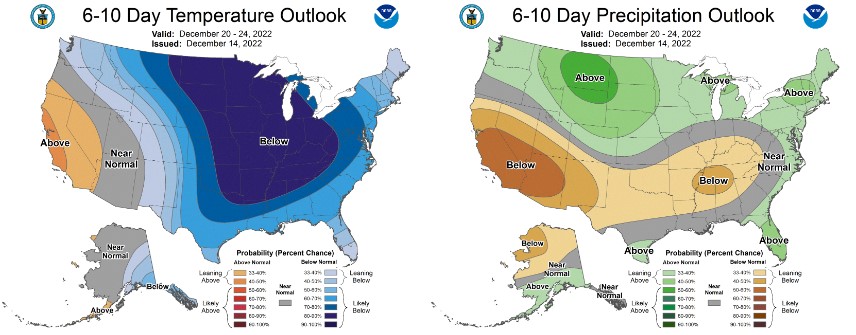
Northerly flow aloft continues. Colder than normal weather will persist for at least the next few days. Sun angles are low this time of year as we approach the winter solstice on December 21st. Temperature inversions are likely today, with air stagnation concerns in the valleys. If this situation doesn't mix out, expect temperatures similar to yesterday...chilly, jacket weather in town and warmer, base layer weather up on the mountain. The wind doesn't look notable and overall, similar conditions are expected into this weekend. Weather models maintain potential for unsettled weather next week, but mostly for areas north of Mount Shasta. More to come on that later. Have a great day!
NWS Climate Prediction Center

