You are here

Forecast Addendum - 12/25/2021 - 07:00am

Submitted by nmeyers on Sat, 12/25/2021 - 5:46am
Recent Observations: 

Christmas Eve began stunningly, bright blue skies and a stark white mountain with snowy spin drift spooling off the ridgelines from the strong W-SW wind. By mid-morning, clouds and fog enveloped the area and light snow began. It was a steady trickle of snow over the day/night. New snow totals over the past 24 hours are as follows:

  • Old Ski Bowl ~ 5 inches
  • Castle Lake ~ 6 inches
  • Mt Eddy ~ 9 inches
  • Ash Creek Butte ~ 1.5 inches

Over on the west side of the freeway in the Eddy Mountains, new snow totals over the past 24 hours are almost double what Shasta observed.

On Gray Butte, the wind has been steady, W-SW, moderate to strong, averaging 20 mi/hr with gusts into the 30-40 mi/hr range. Max gusts reached 61. Temperatures have been chilly, max daytime highs reached 26 F near treeline.

The zipper crust remains below ~7,000 feet, but above, softer snow can be found. Yesterday up along Green Butte ridge and Broadway, a couple of local skiers reported good conditions near and below treeline with moderate westerly wind. Stomping along small cornices and test slopes, the skiers were not able to trigger anything eyebrow raising. They did see something that looked like an avalanche crown over to the west, in the Anaconda drainage, but it was difficult to say for certain. 

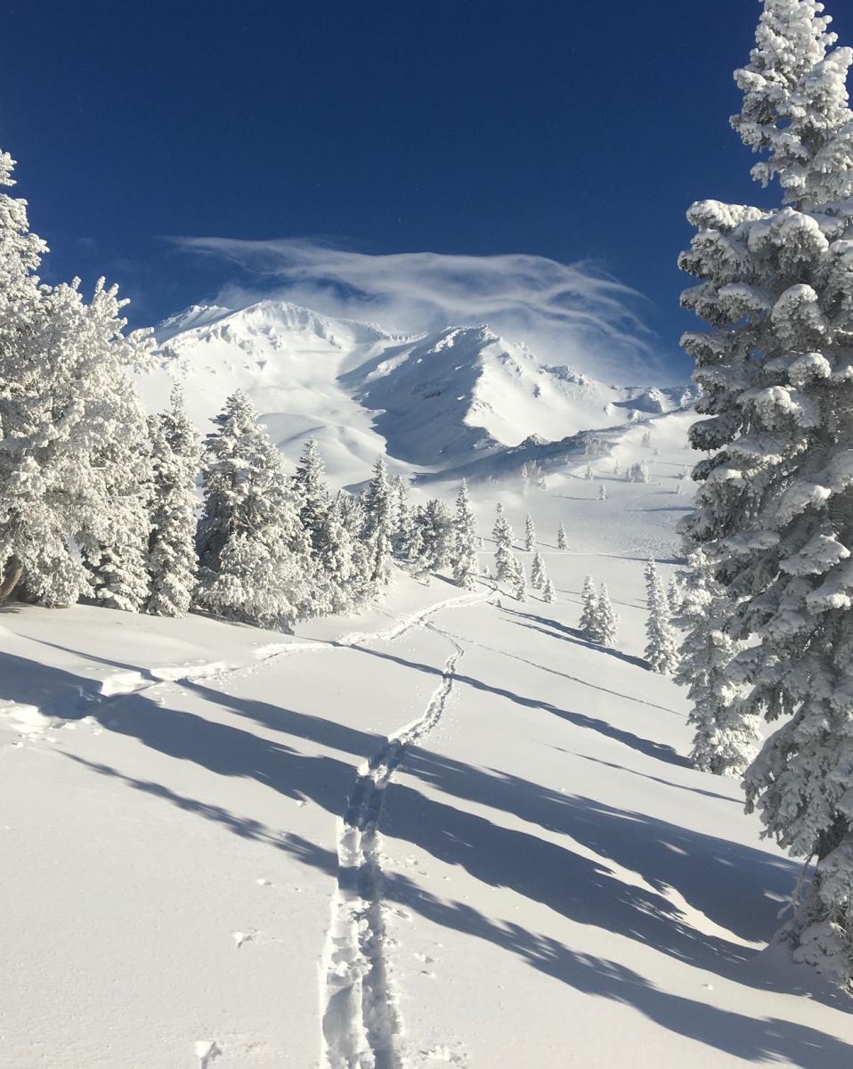
Christmas Eve morning, what began as an incredible blue bird day, quickly became socked in with clouds. [Photo: Chris Carr, Shasta Mtn Guides]


Mountain Weather: 

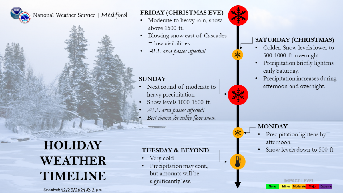
We are in another lull between the storms this morning. This will give Santa a much-needed break for the end of his rounds, though last I heard, Rudolph was shining bright. Precipitation today will be more showery, with some breaks of sun between the showers. Temperatures will remain cold and continue this way for the time being, and thus snow levels are low. Expect travel impacts over the holiday weekend. It's been super windy above treeline on the mountain. Models show this W-SW flow to continue for the next couple of days. Wind chill factors are well below zero and cold, snowy and windy weather should not be taken lightly on Mount Shasta. Despite being just off the Interstate, it's the real deal up there. A winter storm warning remains in effect until 10 AM PST Monday.


Today 7-8 Weather : 
Snow, chance of precipitation 80%. Snow level near 2,500 - 3,000 feet
Today 7-8 Wind Direction: 
SW
Today 8-9 Weather: 
Snow, widespread blowing snow, windy.
Today 8-9 Wind Direction: 
SW
Tomorrow 7-8 Weather: 
Snow, heavy at times, widespread blowing snow, breezy. Snow level near 2,000 feet
Tomorrow 7-8 Wind Direction: 
SW
Tomorrow 8-9 Weather: 
Snow, heavy at times, widespread blowing snow, windy.
Tomorrow 8-9 Wind Direction: 
W
Tonight 7-8 Weather: 
Snow, chance of precipitation 80%. Snow level near 1,000 feet.
Tonight 7-8 Wind Direction: 
SW
Tonight 8-9 Weather: 
Snow, widespread blowing snow, windy.
Tonight 8-9 Wind Direction: 
W
Today 7-8 Temp: 
22
Today 8-9 Temp: 
10
Tomorrow 7-8 Temp: 
21
Tomorrow 8-9 Temp: 
8
Tonight 7-8 Temp: 
12
Tonight 8-9 Temp: 
1
21
16
24
21
0
0
16.5
13.5
18.5
17
69.45
4.8
0.11
Grey Butte Temp Cur: 
16
Grey Butte Temp Min: 
13.5
Grey Butte Temp Max: 
19.5
Grey Butte Temp Avg: 
16.5
Grey Butte Wind Cur: 
21
Grey Butte Wind Max: 
31.5
Grey Butte Wind Avg: 
W
Castle Lake Temp Cur: 
21.5
Castle Lake Temp Min: 
17.5
Castle Lake Temp Max: 
26.5
Castle Lake Temp Avg: 
23
Castle Lake Snow Depth: 
45.21
Castle Lake Snow New: 
6.1
Mount Eddy Temp Cur: 
20
Mount Eddy Temp Min: 
14.5
Mount Eddy Temp Max: 
25
Mount Eddy Temp Avg: 
21
Mount Eddy Wind Cur: 
1.5
Mount Eddy Wind Max: 
2
Mount Eddy Snow Depth: 
50.82
Mount Eddy Snow New: 
9
Ash Creek Bowl Temp Cur: 
19
Ash Creek Bowl Temp Min: 
15
Ash Creek Bowl Temp Max: 
20
Ash Creek Bowl Temp Avg: 
18.5
Ash Creek Bowl Snow New: 
1.5
Ash Creek Ridge Temp Cur: 
15
Ash Creek Ridge Temp Min: 
12
Ash Creek Ridge Temp Max: 
16.5
Ash Creek Ridge Temp Avg: 
15
Ash Creek Ridge Wind Cur: 
0
Ash Creek Ridge Wind Max: 
0
Mt. Shasta City Temp Cur: 
32
Mt. Shasta City Temp Min: 
29
Mt. Shasta City Temp Max: 
36
Mt. Shasta City Temp Avg: 
32.5
Mt. Shasta City Wind Cur: 
0
Mt. Shasta City Wind Min: 
0
Mt. Shasta City Wind Max: 
3
Mt. Shasta City Wind Avg: 
N
Sand Flat Comments: 
State owned station, down
Grey Butte Wind Min: 
12
Mount Eddy Wind Min: 
0.5
Ash Creek Ridge Wind Min: 
0
Sand Flat Snow Settlement: 
0
Ski Bowl Snow Settlement: 
0
Castle Lake Snow Settlement: 
0
Mount Eddy Snow Settlement: 
0
Ash Creek Bowl Snow Settlement: 
0
Measured Precipitation Oct: 
13.09
Normal Precipitation Oct: 
10.79
Percent Precipitation Oct: 
121
Measured Precipitation MTD: 
3.79
Normal Precipitation MTD: 
5.16
Percent Precipitation MTD: 
73
Measured Precipitation YTD: 
29.04
Normal Precipitation YTD: 
36.17
Percent Precipitation YTD: 
80
Today SWE: 
0.08
Tonight SWE: 
0.07
Tomorrow SWE: 
0.21
Today Wind Max 7-9: 
15
Tonight Wind Max 7-9: 
15
Tomorrow Wind Max 7-9: 
15
Today Wind Min 7-9: 
10
Tonight Wind Min 7-9: 
10
Tomorrow Wind Min 7-9: 
10
Today Wind Max 9-11: 
40
Tonight Wind Max 9-11: 
40
Tomorrow Wind Max 9-11: 
50
Today Wind Min 9-11: 
30
Tonight Wind Min 9-11: 
30
Tomorrow Wind Min 9-11: 
40
Today Snow Max 7-9: 
4.00
Tonight Snow Max 7-9: 
3.00
Tomorrow Snow Max 7-9: 
8.00
Today Snow Min 7-9: 
2.00
Tonight Snow Min 7-9: 
2.00
Tomorrow Snow Min 7-9: 
3.00
Today Snow Max 9-11: 
4.00
Tonight Snow Max 9-11: 
4.00
Tomorrow Snow Max 9-11: 
8.00
Today Snow Min 9-11: 
2.00
Tonight Snow Min 9-11: 
2.00
Tomorrow Snow Min 9-11: 
4.00
Ash Creek Bowl HS: 
43.32
Weather Station Discussion: 
The table below summarizes data reported from all of our weather stations over the last 24 hours.
Seasonal Stats Discussion: 
The wet season is October 1 through May 1. The table below summarizes recorded vs. normal precipitation amounts for the City of Mount Shasta.
Overall Danger Rating: 
Considerable
Current Time: 
4:00 AM