Recent Observations:
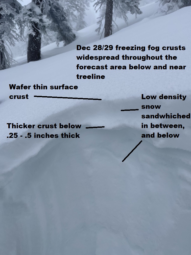
We've been getting a good dose of freezing fog over the past two days, with some light snow in between. A widespread crust has formed on almost all aspects below and near treeline by freezing fog that rolled into the area on December 28th. These crusts are increasingly formidable at lower elevations below treeline, but begins to disappear above 7,500 to 8,000 feet. It's a bit of a crust sandwich. On top of the snowpack, a wafer thin crust resides. Below, 1-2 inches of low density snow sits on top of the stoutest of the two crusts. Above and below the bottom crust layer, low density, weak snow remains. Confused? Check out this photo...
The height of snow at the Old Ski Bowl is 79 inches. The mean temperature was 16 ºF, the low 10, and the high 26. Winds were light and variable, but have picked up out of the NW this morning. At Castle Lake (the road is now OPEN), snow depth there measured 73 inches near the bottom of Left Peak.
A couple of small (D1), isolated avalanches have been seen, but very little evidence of instabilities have been witnessed aside from sensitive cornices. Visibility and wind has kept most observers away from above treeline elevations, so some uncertainty exists up there.
Mountain Weather:
We're in for a break in precipitation over the next couple of days, but hang on to your hats because things are going to get a little western in alpine terrain. Northwest wind will increase this morning and settle in for a good blow through Saturday morning. Expect wind speeds 50+ mi/hr above treeline on Mount Shasta and exposed terrain elsewhere. The wind will begin to die off Saturday and switch to more southwest to west flow. This switch will signal the start of a warmer pattern bringing periods of high impact weather beginning Sunday and into next week. More on those storms later. Yee-haw, rid'em cow-poker!
Today 7-8 Weather :
Partly cloudy, slight chance of snow, little to no accumulation, northwest wind increasing
Today 7-8 Wind Direction:
W
Today 8-9 Weather:
A 10% chance of snow after 4 PM. Widespread blowing snow, partly cloudy, windy, cold
Today 8-9 Wind Direction:
NW
Tomorrow 7-8 Weather:
Partly cloudy, blustery north wind, patchy blowing snow
Tomorrow 7-8 Wind Direction:
NW
Tomorrow 8-9 Weather:
Partly cloudy, widespread blowing snow, windy, cold
Tomorrow 8-9 Wind Direction:
N
Tonight 7-8 Weather:
Mostly cloudy, 20% chance of snow, windy
Tonight 7-8 Wind Direction:
W
Tonight 8-9 Weather:
A 20% chance of snow before 10 PM. Widespread blowing snow, mostly cloudy, windy, cold
Tonight 8-9 Wind Direction:
NW
Ash Creek Ridge Temp Cur:
11
Ash Creek Ridge Temp Min:
8.5
Ash Creek Ridge Temp Max:
21
Ash Creek Ridge Temp Avg:
13.5
Ash Creek Ridge Wind Cur:
0
Ash Creek Ridge Wind Max:
0
Mt. Shasta City Temp Cur:
22
Mt. Shasta City Temp Min:
15
Mt. Shasta City Temp Max:
34
Mt. Shasta City Temp Avg:
26
Mt. Shasta City Wind Cur:
0
Mt. Shasta City Wind Min:
0
Mt. Shasta City Wind Max:
3
Mt. Shasta City Wind Avg:
N
Ash Creek Ridge Wind Min:
0
Sand Flat Snow Settlement:
0
Ski Bowl Snow Settlement:
0
Castle Lake Snow Settlement:
1.1
Mount Eddy Snow Settlement:
3
Ash Creek Bowl Snow Settlement:
0.3
Measured Precipitation Oct:
13.35
Normal Precipitation Oct:
11.84
Percent Precipitation Oct:
113
Measured Precipitation MTD:
4.05
Normal Precipitation MTD:
6.21
Percent Precipitation MTD:
65
Measured Precipitation YTD:
29.3
Normal Precipitation YTD:
37.22
Percent Precipitation YTD:
79
Weather Station Discussion:
The table below summarizes data reported from all of our weather stations over the last 24 hours.
Seasonal Stats Discussion:
The wet season is October 1 through May 1. The table below summarizes recorded vs. normal precipitation amounts for the City of Mount Shasta.


