Submitted by nmeyers on Fri, 12/30/2022 - 5:56am
Recent Observations:
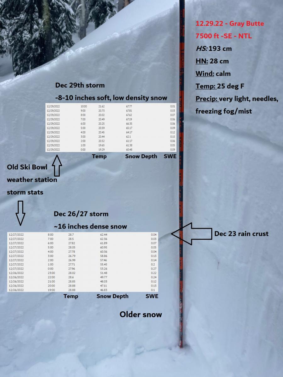
Yesterday's observations were lackluster in the unstable snow department. It was one of those freezing fog, misty, poor visibility days...the kind that ruins your goggles in about 30 seconds flat if skiing or riding. The short, punchy storm that rolled through overnight on December 28-29 brought 8–10 inches above 7,000 feet. Precipitation ended at 1000 hours and kicked back in at 1700. Temperatures started off cool, but have been warming. Westerly wind was calm midday, but turned on last night. Storm snow stability is good below and near treeline. I was unable to get into colder, windier, upper elevation terrain due to whiteout conditions.
- December 26/27 storm, 8–14 inches above 7,000 feet of dense snow that is well pasted to existing snow surfaces
- December 29th storm, 8–10 inches above 7,000 feet of soft snow resting on top of heavy, dense snow
- Potential weak layers of snow will reside in new storm snow and/or new/old snow interface since December 29th.
- In the last 24 hours:
- Temps (low/high): 19/24 deg F
- Wind (avg/max): 11/37 mi/hr - West
- Precip (SWE): 1.08" snow-water equivalent
- Height of Snow - Mt. Shasta: 72" / Castle Lake: snow depth sensor down, estimated 50" / Mt. Eddy: 48" inches / Ash Creek Butte: 58"
Mountain Weather:
We are riding the second wave of the storm train, and it's a warm one. Rain, snow and strong westerly wind over higher terrain will prevail for daylight hours today, tapering off late this evening and into Saturday morning. Snow levels are once again painfully high: 8,000 feet today, lowering to 6,500 feet tonight and 4,500 feet tomorrow. Cooling off, yes, but too little, too late with this storm. Snow is likely above treeline on Mt. Shasta. Near and below treeline, a winter mix of rain and snow. Precipitation will end from northwest to southeast Saturday afternoon. A short-lived break in the action will follow on Sunday. A colder front with lower snow levels moves onshore Monday, and the associated energy will be focused on northern California.
Today 7-8 Weather :
Snow before 1pm, then rain. Windy. Snow level 8,000 feet
Today 7-8 Wind Direction:
SW
Today 8-9 Weather:
Snow, windy
Today 8-9 Wind Direction:
W
Tomorrow 7-8 Weather:
Snow in the morning, clearing in the afternoon. Snow level 6,500 feet lowering to 4,500 feet
Tomorrow 7-8 Wind Direction:
N
Tomorrow 8-9 Weather:
Snow, windy, clearing
Tomorrow 8-9 Wind Direction:
N
Tonight 7-8 Weather:
Rain and snow. Precipitation tapering off after 8pm. Snow level 8,000 feet lowering to 6,500 feet
Tonight 7-8 Wind Direction:
SW
Tonight 8-9 Weather:
Snow, windy
Tonight 8-9 Wind Direction:
W
28
24
28
27
52
5
0
24.5
20
25
23
71.98
7.5
1.16
Grey Butte Temp Cur:
23.5
Grey Butte Temp Max:
23.5
Grey Butte Temp Avg:
21.5
Grey Butte Wind Max:
14.5
Grey Butte Wind Gust Max:
36.8
Castle Lake Temp Min:
27.5
Castle Lake Temp Avg:
30.5
Mount Eddy Temp Cur:
30.5
Mount Eddy Temp Avg:
27.5
Mount Eddy Wind Gust Max:
5.38
Mount Eddy Snow Depth:
47.34
Ash Creek Bowl Temp Cur:
27.5
Ash Creek Bowl Temp Min:
22
Ash Creek Bowl Temp Max:
28.5
Ash Creek Bowl Temp Avg:
25
Ash Creek Bowl Snow New:
15.5
Ash Creek Ridge Temp Cur:
28.5
Ash Creek Ridge Temp Min:
18.5
Ash Creek Ridge Temp Max:
28.5
Ash Creek Ridge Temp Avg:
22
Ash Creek Ridge Wind Cur:
0
Ash Creek Ridge Wind Max:
0
Ash Creek Ridge Wind Gust Max:
0
Mt. Shasta City Temp Cur:
38
Mt. Shasta City Temp Min:
33
Mt. Shasta City Temp Max:
38
Mt. Shasta City Temp Avg:
35.5
Mt. Shasta City Wind Cur:
7
Mt. Shasta City Wind Min:
3
Mt. Shasta City Wind Max:
7
Mt. Shasta City Wind Avg:
4
Mt. Shasta City Wind Avg:
ESE
Ash Creek Ridge Wind Min:
0
Ash Creek Ridge Wind Avg:
0
Sand Flat Snow Settlement:
0
Ski Bowl Snow Settlement:
0
Mount Eddy Snow Settlement:
0
Ash Creek Bowl Snow Settlement:
0
Measured Precipitation Oct:
8.39
Normal Precipitation Oct:
11.84
Percent Precipitation Oct:
71
Measured Precipitation MTD:
5.06
Normal Precipitation MTD:
6.21
Percent Precipitation MTD:
81
Measured Precipitation YTD:
16.34
Normal Precipitation YTD:
37.22
Percent Precipitation YTD:
44
Tomorrow Wind Max 7-9:
15
Tonight Wind Max 9-11:
30
Tomorrow Wind Max 9-11:
25
Tonight Wind Min 9-11:
20
Tomorrow Wind Min 9-11:
15
Tonight Snow Max 7-9:
4.00
Tomorrow Snow Max 7-9:
3.00
Tonight Snow Min 7-9:
2.00
Tomorrow Snow Min 7-9:
1.00
Today Snow Max 9-11:
8.00
Tonight Snow Max 9-11:
6.00
Tomorrow Snow Max 9-11:
4.00
Today Snow Min 9-11:
4.00
Tonight Snow Min 9-11:
3.00
Tomorrow Snow Min 9-11:
2.00
Weather Station Discussion:
The table below summarizes data reported from all of our weather stations over the last 24 hours.
Seasonal Stats Discussion:
The wet season is October 1 through May 1. The table below summarizes recorded vs. normal precipitation amounts for the City of Mount Shasta.
Overall Danger Rating:
Considerable


