Submitted by nmeyers on Thu, 12/08/2022 - 5:19am
Recent Observations:
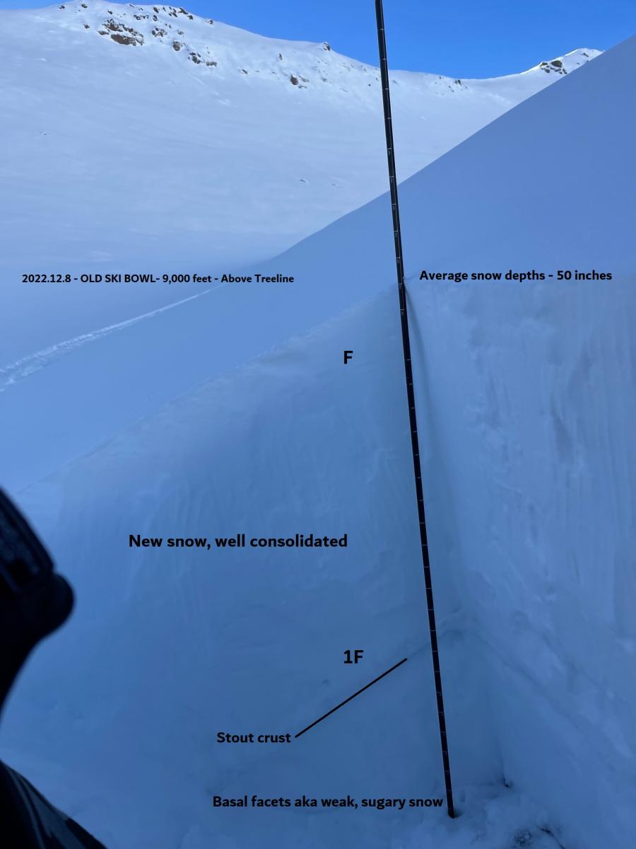
Early November brought inklings of winter that was followed by high pressure. Early season snow turned into weak, sugary facets at ground level. December 1st, winter kicked off with a nice storm, followed by a few more. The avalanche danger has ebbed and flowed with the weather and a few weaknesses have been observed in the snowpack, but none of them lasting, and no avalanches have ensued. The most notable weak layer in the snowpack is the loose, sugary snow near the ground. This layer has produced a few eyebrow raising stability test results, but unlike our Sierra neighbors, we have not observed any avalanches on this layer, or at all. Much of the weak snow near the ground remains held together by ground anchoring objects like rocks and trees, and is capped off with a solid crust. We are uncertain how much load may activate the basal facet layers. It's something to keep in mind as we hop on the storm train the next couple of days. Otherwise, fresh, low density snow makes up the remainder of the snowpack. A few thin crusts have been forming here and there. Widespread surface hoar (feathery snow crystals on the snow surface) has formed below and near treeline and remained intact as of last night. This is a classic weak layer and will become buried today.
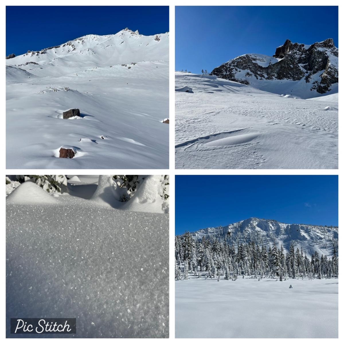
Photos above starting top left, clockwise [12.7.22 - Meyers]: 9k ft in Old Ski Bowl; East Face of Green Butte and wind texture; West Face of Gray Butte; Widespread surface hoar below and near treeline
Below: Old Ski Bowl pit
Mountain Weather:
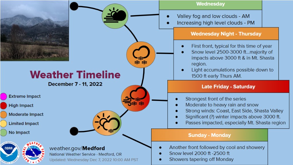
The storm train is steaming our way and we are gassed! A series of storms will bring feet of snow over the next several days and into the weekend. Thirty hour storm total predictions show 2.5 to 3.5 inches of water for southern Siskiyou County. Precipitation will arrive at the coast early this morning and move inland today. Snow levels are low, near ~2,500 feet, and a WINTER STORM WARNING IS IN EFFECT FROM 10 AM THIS MORNING TO 10 PM PST THIS EVENING. Mount Shasta City will get about an inch of water over the next 24 hours, which could mean upwards of a foot or more of new snow in the mountains. Solid south/southwest flow always enhances precipitation rates for Mount Shasta, and this looks to be the case with these storms...the good 'ol Shasta Snowmaker is ON! Temperatures will remain chilly and expect widespread blowing snow from moderate to strong southwest wind.
Today 7-8 Weather :
Snow, mainly after 10 AM, breezy. Chance of precipitation, 100%. Snow level near 3,500 feet
Today 7-8 Wind Direction:
S
Today 8-9 Weather:
Snow and windy. Wind chill near -18 F
Today 8-9 Wind Direction:
S
Tomorrow 7-8 Weather:
Mostly cloudy, breezy, chance of snow showers after 10 AM. Snow level near 2,300 feet
Tomorrow 7-8 Wind Direction:
S
Tomorrow 8-9 Weather:
Snow showers, windy, widespread blowing snow, wind chill near -23 F
Tomorrow 8-9 Wind Direction:
SW
Tonight 7-8 Weather:
Snow before 10 PM, then snow showers. Chance of precipitation, 100%. Snow level near 2,700 feet
Tonight 7-8 Wind Direction:
SW
Tonight 8-9 Weather:
Snow and windy. Wind chill near -24 F
Tonight 8-9 Wind Direction:
SW
24
12
30
22
20
17.5
29.5
21.5
45.36
0
0.04
Grey Butte Temp Min:
17.5
Grey Butte Temp Avg:
20.5
Grey Butte Wind Gust Max:
30.66
Castle Lake Temp Cur:
25.5
Castle Lake Temp Min:
22.5
Castle Lake Temp Max:
29.5
Castle Lake Temp Avg:
25.5
Mount Eddy Temp Cur:
23.5
Mount Eddy Temp Avg:
22.5
Mount Eddy Wind Gust Max:
4.2
Mount Eddy Snow Depth:
29.16
Ash Creek Bowl Temp Cur:
21.5
Ash Creek Bowl Temp Min:
15
Ash Creek Bowl Temp Max:
24
Ash Creek Bowl Temp Avg:
20
Ash Creek Bowl Snow New:
0
Ash Creek Ridge Temp Cur:
18
Ash Creek Ridge Temp Min:
14
Ash Creek Ridge Temp Max:
30
Ash Creek Ridge Temp Avg:
19.5
Ash Creek Ridge Wind Cur:
0
Ash Creek Ridge Wind Max:
9.5
Ash Creek Ridge Wind Gust Max:
31.8
Mt. Shasta City Temp Cur:
37
Mt. Shasta City Temp Min:
22
Mt. Shasta City Temp Max:
42
Mt. Shasta City Temp Avg:
34.5
Mt. Shasta City Wind Cur:
4
Mt. Shasta City Wind Min:
0
Mt. Shasta City Wind Max:
6
Mt. Shasta City Wind Avg:
2
Mt. Shasta City Wind Avg:
N
Ash Creek Ridge Wind Min:
0
Ash Creek Ridge Wind Avg:
1
Ski Bowl Snow Settlement:
1.6
Ash Creek Bowl Snow Settlement:
2.4
Measured Precipitation Oct:
4.94
Normal Precipitation Oct:
7.11
Percent Precipitation Oct:
69
Measured Precipitation MTD:
1.61
Normal Precipitation MTD:
1.48
Percent Precipitation MTD:
109
Measured Precipitation YTD:
12.89
Normal Precipitation YTD:
32.49
Percent Precipitation YTD:
40
Tomorrow Wind Max 7-9:
20
Tomorrow Wind Min 7-9:
10
Tonight Wind Max 9-11:
45
Tomorrow Wind Max 9-11:
40
Tonight Wind Min 9-11:
35
Tomorrow Wind Min 9-11:
30
Today Snow Max 7-9:
11.00
Tonight Snow Max 7-9:
7.00
Tomorrow Snow Max 7-9:
3.00
Tonight Snow Min 7-9:
3.00
Tomorrow Snow Min 7-9:
1.00
Today Snow Max 9-11:
14.00
Tonight Snow Max 9-11:
8.00
Tomorrow Snow Max 9-11:
3.00
Today Snow Min 9-11:
10.00
Tonight Snow Min 9-11:
4.00
Tomorrow Snow Min 9-11:
1.00
Weather Station Discussion:
The table below summarizes data reported from all of our weather stations over the last 24 hours.
Seasonal Stats Discussion:
The wet season is October 1 through May 1. The table below summarizes recorded vs. normal precipitation amounts for the City of Mount Shasta.
Overall Danger Rating:
Considerable


