Submitted by nmeyers on Fri, 01/06/2023 - 5:38am
Recent Observations:
Since the beginning of the active weather pattern that started on January 3rd, we have received about 2.5 feet of heavy, dense snow above 7,000 feet, with water equivalent of approximately five inches. Visibility, observations and backcountry access have been limited, but we were still able to snowmobile up onto Mount Shasta yesterday and assess the snow stability.
Powder-over-the- hood riding was expected, but to our surprise, snowmobile penetration was only about six inches. On an easterly aspect near treeline at 8,000 feet, numerous, repeatable extended column tests failed upon isolation. A 2.5 foot thick hard slab rests tenuously on a thin crust/weak layer. This weak layer is fairly widespread. These eyebrow raising stability test results indicate a touchy snowpack near and above treeline. During the storm, snow levels hovered around 6,000 feet. The snowpack below treeline is a wet, mushy mess. Rain runnels and tree litter are a common sight. 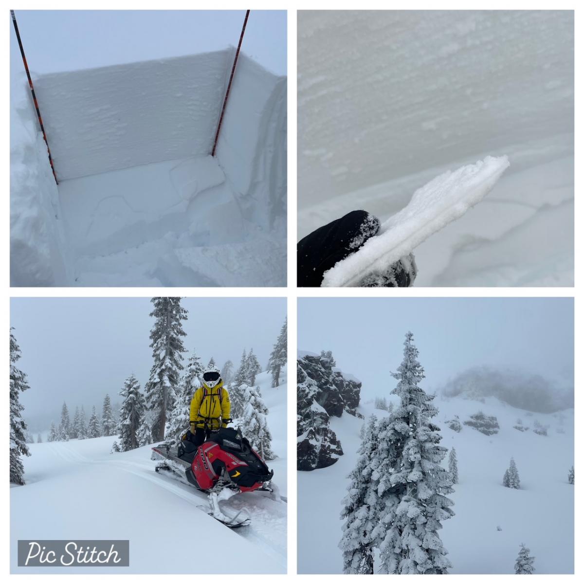
1.5.22 / Clockwise from top left: 1) Numerous extended column tests failing upon isolation, ~2.5 feet down from the surface on a crust/weak layer of snow 2) Thin crust with weak snow surrounding 3) Poor visibility conditions near treeline on Mount Shasta, ~8,000 feet 4) Snowmobile penetration in the 2.5 feet of fresh snow, only about six inches
Mountain Weather:
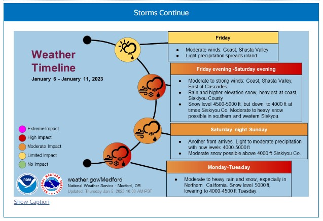
A parade of impactful atmospheric river events continues over the west for at least the next several days. The next round of excessive precipitation will enter northern California today. Southerly, up slope flow into Siskiyou County, particularly the Mount Shasta region, will result in precipitation breaking out again late this morning. South winds will strengthen ahead of the front. Liquid amounts for the next 48 hours are expected to be in the 4 to 5 inch range. By Saturday night into early Sunday, the next moisture-laden Pacific cyclone is forecast to approach California, with the onslaught of heavy precipitation once again aiming for northern California. Temperatures are colder; snow levels will linger near 4,400 feet today and tonight, falling to 4,000 feet Saturday and near 3,000 feet Sunday. Hold onto your hats!
Today 7-8 Weather :
Snow, heavy at times, breezy. Snow level near 4,400 feet
Today 7-8 Wind Direction:
S
Today 8-9 Weather:
Snow, heavy at times, windy
Today 8-9 Wind Direction:
SW
Tomorrow 7-8 Weather:
Snow, heavy at times, windy. Snow level near 4,000 feet
Tomorrow 7-8 Wind Direction:
S
Tomorrow 8-9 Weather:
Snow, heavy at times, windy
Tomorrow 8-9 Wind Direction:
S
Tonight 7-8 Weather:
Snow, heavy at times, windy. Snow level near 4,500 feet
Tonight 7-8 Wind Direction:
S
Tonight 8-9 Weather:
Snow, heavy at times, windy
Tonight 8-9 Wind Direction:
S
23
23
33
30
66
4
0
16.5
16.5
26.5
22.5
95.1
2.7
2.19
Grey Butte Temp Cur:
18.5
Grey Butte Temp Min:
18.5
Grey Butte Wind Cur:
15.5
Grey Butte Wind Max:
15.5
Grey Butte Wind Gust Max:
30.66
Castle Lake Temp Min:
26.5
Castle Lake Temp Avg:
32.5
Mount Eddy Temp Cur:
18.5
Mount Eddy Temp Min:
18.5
Mount Eddy Temp Avg:
26.5
Mount Eddy Wind Gust Max:
6.2
Mount Eddy Snow Depth:
63
Ash Creek Bowl Temp Cur:
25
Ash Creek Bowl Temp Min:
23
Ash Creek Bowl Temp Max:
25
Ash Creek Bowl Temp Avg:
23.5
Ash Creek Ridge Temp Cur:
18
Ash Creek Ridge Temp Min:
18
Ash Creek Ridge Temp Max:
25.5
Ash Creek Ridge Temp Avg:
23.5
Ash Creek Ridge Wind Cur:
0
Ash Creek Ridge Wind Max:
0
Ash Creek Ridge Wind Gust Max:
0
Mt. Shasta City Temp Cur:
36
Mt. Shasta City Temp Min:
35
Mt. Shasta City Temp Max:
44
Mt. Shasta City Temp Avg:
40
Mt. Shasta City Wind Cur:
3
Mt. Shasta City Wind Min:
0
Mt. Shasta City Wind Max:
5
Mt. Shasta City Wind Avg:
3
Mt. Shasta City Wind Avg:
ESE
Grey Butte Wind Avg:
10.5
Ash Creek Ridge Wind Min:
0
Ash Creek Ridge Wind Avg:
0
Sand Flat Snow Settlement:
0
Ski Bowl Snow Settlement:
0
Mount Eddy Snow Settlement:
1
Measured Precipitation Oct:
12.51
Normal Precipitation Oct:
13.31
Percent Precipitation Oct:
94
Measured Precipitation MTD:
3.38
Normal Precipitation MTD:
1.07
Percent Precipitation MTD:
316
Measured Precipitation YTD:
3.38
Normal Precipitation YTD:
1.07
Percent Precipitation YTD:
316
Tomorrow Wind Max 7-9:
35
Tomorrow Wind Min 7-9:
25
Tonight Wind Max 9-11:
60
Tomorrow Wind Max 9-11:
70
Tonight Wind Min 9-11:
50
Tomorrow Wind Min 9-11:
60
Today Snow Max 7-9:
13.00
Tonight Snow Max 7-9:
20.00
Tomorrow Snow Max 7-9:
15.00
Tonight Snow Min 7-9:
14.00
Tomorrow Snow Min 7-9:
9.00
Today Snow Max 9-11:
16.00
Tonight Snow Max 9-11:
23.00
Tomorrow Snow Max 9-11:
18.00
Today Snow Min 9-11:
10.00
Tonight Snow Min 9-11:
17.00
Tomorrow Snow Min 9-11:
12.00
Weather Station Discussion:
The table below summarizes data reported from all of our weather stations over the last 24 hours.
Seasonal Stats Discussion:
The wet season is October 1 through May 1. The table below summarizes recorded vs. normal precipitation amounts for the City of Mount Shasta.
Overall Danger Rating:
High


