Submitted by nmeyers on Sat, 01/07/2023 - 5:32am
Recent Observations:
Yesterday's forecast was a bust! New snow totals forecast were 7-13" for the day and 14-20" for the night, aaand....we got 3 inches over the past 24 hours. What ya gonna do. Below treeline, rain runnels are the main attraction. Warm and wet has been a theme this week. All areas below ~6,500 feet have been heavily impacted by rain, the avalanche danger squashed, and the snowpack turned into good 'ol Shasta plaster. Rain runnels begin to dissipate from 6,000 to 7,000 feet. Above that, things begin to feel more winter like. It is these upper elevation zones that have been the main concern for avalanche danger. Access and visibility have been difficult. The Everitt Memorial Highway is still closed due to equipment mechanicals. Observations have been limited, however yesterday at 1410, an unusual seismic signal was observed on stations of the USGS Northern California Seismic Network deployed on Mount Shasta. The signal is spindle shaped with an increasing then decreasing amplitude. This type of signal is often correlated with snow avalanches. The highest amplitudes were observed at a station located on the east flank of the mountain. While this seismic signal is indicative of a very large avalanche, there has been no visual confirmation that an avalanche occurred. We look forward to getting eyes onto the mountain when visibility allows. (Thanks to Phil Dawson from the USGS)
Since the beginning of the active weather pattern that started on January 3rd, we have received about 2 - 3 feet of heavy, dense snow above 7,000 feet, with water equivalent of approximately five inches.
In the last 24 hours at 8,000 feet:
- Temperatures have ranged from 21 to 26 degrees F
- New snow accumulation: 3 inches (.58" liquid equivalent) / Total height of snow: 98 inches
- Wind has averaged 10 mi/hr with gusts to 36 mi/hr out of the south-southeast
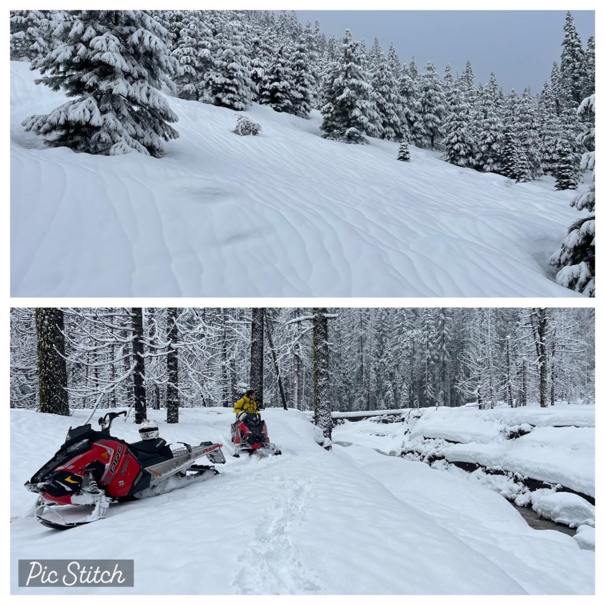
1.6.23 - N Meyers - Top: Rain runnels the main attraction below ~6,000 feet / Bottom: FS road 31 and Mud Creek crossing, impassable
Mountain Weather:
A relentless bombardment from the Pacific will bring more rain and mountain snow to the West Coast, with the main focus across northern California. The most persistent rain and snow will be in Siskiyou County and northwestward to the coast ranges. Snow levels are near 4,500 feet. Cooling later this afternoon and tonight will lower the snow level a bit. In the mountains above Mount Shasta City, 10–20 inches of snow is expected, with snowfall rates of one inch per hour tonight into Sunday. Periods of extreme winds and blizzard conditions above treeline for the next several days are likely. A winter storm warning is in effect for the area.
Today 7-8 Weather :
Snow, heavy at times, periods of extreme winds and blizzard conditions. Snow level near 4,500 feet
Today 7-8 Wind Direction:
S
Today 8-9 Weather:
Snow, heavy at times, windy
Today 8-9 Wind Direction:
S
Tomorrow 7-8 Weather:
Snow, mainly before 4pm, heavy at times, breezy. Snow level near 4,000 feet
Tomorrow 7-8 Wind Direction:
S
Tomorrow 8-9 Weather:
Snow, heavy at times, windy
Tomorrow 8-9 Wind Direction:
S
Tonight 7-8 Weather:
Snow, heavy at times, windy. Snow level near 4,100 feet
Tonight 7-8 Wind Direction:
S
Tonight 8-9 Weather:
Snow, heavy at times, windy
Tonight 8-9 Wind Direction:
S
27
23
30
28
69
4
0
23.5
19
26
24.5
97.2
2.2
0.5
Grey Butte Temp Max:
25.5
Grey Butte Temp Avg:
23.5
Grey Butte Wind Cur:
12.5
Grey Butte Wind Gust Max:
36.8
Castle Lake Temp Cur:
29.5
Castle Lake Temp Max:
32.5
Castle Lake Temp Avg:
30.5
Mount Eddy Temp Cur:
26.5
Mount Eddy Temp Avg:
26.5
Mount Eddy Wind Gust Max:
8.95
Mount Eddy Snow Depth:
67.55
Ash Creek Bowl Temp Cur:
25
Ash Creek Bowl Temp Min:
23
Ash Creek Bowl Temp Max:
25
Ash Creek Bowl Temp Avg:
23.5
Ash Creek Ridge Temp Cur:
21.5
Ash Creek Ridge Temp Min:
16.5
Ash Creek Ridge Temp Max:
23.5
Ash Creek Ridge Temp Avg:
21.5
Ash Creek Ridge Wind Cur:
0
Ash Creek Ridge Wind Max:
0
Ash Creek Ridge Wind Gust Max:
0
Mt. Shasta City Temp Cur:
34
Mt. Shasta City Temp Min:
34
Mt. Shasta City Temp Max:
40
Mt. Shasta City Temp Avg:
37.5
Mt. Shasta City Wind Cur:
5
Mt. Shasta City Wind Min:
0
Mt. Shasta City Wind Max:
5
Mt. Shasta City Wind Avg:
2.5
Mt. Shasta City Wind Avg:
N
Grey Butte Wind Avg:
10.5
Ash Creek Ridge Wind Min:
0
Ash Creek Ridge Wind Avg:
0
Sand Flat Snow Settlement:
0
Ski Bowl Snow Settlement:
0
Mount Eddy Snow Settlement:
0
Measured Precipitation Oct:
13.06
Normal Precipitation Oct:
13.53
Percent Precipitation Oct:
97
Measured Precipitation MTD:
3.93
Normal Precipitation MTD:
1.29
Percent Precipitation MTD:
305
Measured Precipitation YTD:
3.93
Normal Precipitation YTD:
1.29
Percent Precipitation YTD:
305
Tomorrow Wind Max 7-9:
25
Tomorrow Wind Min 7-9:
15
Tonight Wind Max 9-11:
60
Tomorrow Wind Max 9-11:
50
Tonight Wind Min 9-11:
50
Tomorrow Wind Min 9-11:
40
Today Snow Max 7-9:
18.00
Tonight Snow Max 7-9:
20.00
Tomorrow Snow Max 7-9:
10.00
Today Snow Min 7-9:
12.00
Tonight Snow Min 7-9:
12.00
Tomorrow Snow Min 7-9:
5.00
Today Snow Max 9-11:
20.00
Tonight Snow Max 9-11:
22.00
Tomorrow Snow Max 9-11:
12.00
Today Snow Min 9-11:
14.00
Tonight Snow Min 9-11:
14.00
Tomorrow Snow Min 9-11:
7.00
Weather Station Discussion:
The table below summarizes data reported from all of our weather stations over the last 24 hours.
Seasonal Stats Discussion:
The wet season is October 1 through May 1. The table below summarizes recorded vs. normal precipitation amounts for the City of Mount Shasta.
Overall Danger Rating:
High


