Submitted by nmeyers on Fri, 02/03/2023 - 5:57am
Recent Observations:
A bombproof snowpack exists throughout the forecast area. If my life depended on finding red flags of avalanche danger, I'd be dead. Generally smooth and slick surfaces will host new snow in the coming days. Yesterday, a few high clouds began to filter in, but overall it was mostly clear. A large lenticular cloud hung over the mountain for the majority of the day. Wind was light to moderate down near treeline, but the lens clouds indicated different conditions on the upper mountain. Snow surfaces are ragged below and near treeline. Tree debris is littered all over the snow pack. It's quite the spectacle and will take a foot or more of new snow to cover up the branches and limbs. Some softening occurred on sunny slopes, though it was very firm and icy in the AM hours. In the past 24 hours, no new snow has fallen. Light snow has commenced early this morning at 0600 hours. Current snow depth at treeline on Mount Shasta is 124 inches. Temperatures have ranged from 20° to 35° F. The wind picked up late last night and has blown predominantly out of the south and southeast, averaging 10 mi/hr with gusts to 42 mi/hr.
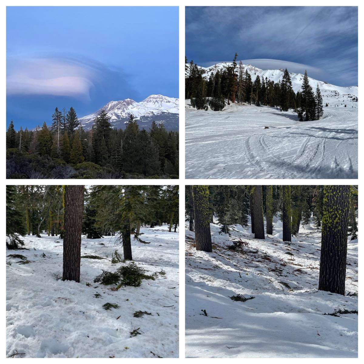
Photos taken on 2/2/23 on Mount Shasta, below and near treeline. A lenticular hung on the upper mountain for most of the day. / Meyers
Mountain Weather:
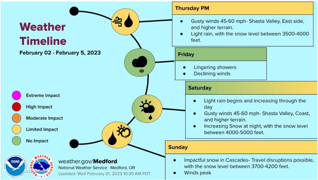
Upper-level energy will push onshore today. This marks the beginning of a progressive pattern, with systems passing through every two days or so. None of these systems are expected to be strong. Precipitation is moving inland this morning. Snow levels will hover around 3,500 to 4,000 feet. South/southwest flow will bring the heaviest precipitation to the Marble Mountains as well as the Mount Shasta area due to enhanced up slope, terrain induced precipitation. Minor issues on roads and highways are likely, with 3–5 inches forecast for Snowman's Summit. In general, 1–2 inches is likely for most roadways. Up on the mountain, expect a few inches more and gusty, south wind. A short break will ensue Friday afternoon. On Saturday morning, we'll start out with upper ridging over the area, but that will quickly move east as a trough approaches. Saturday evening through Sunday evening, we could see a fairly decent dollop of snow above 6,500 feet.
Today 7-8 Weather :
Snow likely, mainly before 10am, then chance of showers. Snow could be heavy at times, breezy. Snow level near 4,100 feet
Today 7-8 Wind Direction:
S
Today 8-9 Weather:
Snow likely, mainly before 10am. Snow heavy at times, windy
Today 8-9 Wind Direction:
SW
Tomorrow 7-8 Weather:
Cloudy, windy. A 30% chance of snow showers. Snow level near 4,900 feet
Tomorrow 7-8 Wind Direction:
S
Tomorrow 8-9 Weather:
Cloudy, windy, a 30% chance of snow showers after 10am
Tomorrow 8-9 Wind Direction:
SW
Tonight 7-8 Weather:
Mostly cloudy. Snow level near 4,400 feet
Tonight 7-8 Wind Direction:
S
Tonight 8-9 Weather:
Mostly cloudy, temperatures rising, windy
Tonight 8-9 Wind Direction:
SW
26
26
35
30
98
0
0
21
21
35
27
124.6
0
0
Grey Butte Wind Cur:
16.5
Grey Butte Wind Gust Max:
42.93
Castle Lake Temp Cur:
29.5
Castle Lake Temp Min:
28.5
Mount Eddy Temp Cur:
26.5
Mount Eddy Wind Gust Max:
11.72
Mount Eddy Snow Depth:
98.8
Ash Creek Bowl Temp Cur:
22.5
Ash Creek Bowl Temp Min:
22.5
Ash Creek Bowl Temp Max:
31
Ash Creek Bowl Temp Avg:
27
Ash Creek Bowl Snow New:
0
Ash Creek Ridge Temp Cur:
19
Ash Creek Ridge Temp Min:
18
Ash Creek Ridge Temp Max:
27.5
Ash Creek Ridge Temp Avg:
23
Ash Creek Ridge Wind Cur:
21
Ash Creek Ridge Wind Max:
26.5
Ash Creek Ridge Wind Gust Max:
43.78
Ash Creek Ridge Wind Avg:
E
Mt. Shasta City Temp Cur:
40
Mt. Shasta City Temp Min:
22
Mt. Shasta City Temp Max:
53
Mt. Shasta City Temp Avg:
36.5
Mt. Shasta City Wind Cur:
0
Mt. Shasta City Wind Min:
0
Mt. Shasta City Wind Max:
0
Mt. Shasta City Wind Avg:
0
Mt. Shasta City Wind Avg:
N
Grey Butte Wind Avg:
10.5
Ash Creek Ridge Wind Min:
8
Ash Creek Ridge Wind Avg:
20.5
Sand Flat Snow Settlement:
1
Ski Bowl Snow Settlement:
0.2
Mount Eddy Snow Settlement:
1.8
Ash Creek Bowl Snow Settlement:
0
Measured Precipitation Oct:
25.88
Normal Precipitation Oct:
18.91
Percent Precipitation Oct:
137
Measured Precipitation MTD:
0
Normal Precipitation MTD:
0.38
Percent Precipitation MTD:
0
Measured Precipitation YTD:
16.75
Normal Precipitation YTD:
6.67
Percent Precipitation YTD:
251
Tomorrow Wind Max 7-9:
20
Tomorrow Wind Min 7-9:
10
Tonight Wind Max 9-11:
45
Tomorrow Wind Max 9-11:
35
Tonight Wind Min 9-11:
35
Tomorrow Wind Min 9-11:
25
Tonight Snow Max 7-9:
1.00
Tomorrow Snow Max 7-9:
3.00
Tonight Snow Min 7-9:
0.00
Tomorrow Snow Min 7-9:
1.00
Today Snow Max 9-11:
9.00
Tonight Snow Max 9-11:
1.00
Tomorrow Snow Max 9-11:
4.00
Today Snow Min 9-11:
5.00
Tonight Snow Min 9-11:
0.00
Tomorrow Snow Min 9-11:
2.00
Weather Station Discussion:
The table below summarizes data reported from all of our weather stations over the last 24 hours.
Seasonal Stats Discussion:
The wet season is October 1 through May 1. The table below summarizes recorded vs. normal precipitation amounts for the City of Mount Shasta.
Overall Danger Rating:
Moderate


