Submitted by sclairmont on Mon, 02/13/2023 - 5:07am
Recent Observations:
In the last 24 hours, high pressure prevailed over the forecast area. Strong northeast winds continued to blow at high elevations above treeline. Winds remained light, with moderate gusts near and below treeline. Temperatures skyrocketed through the day. Gray Butte weather station (~8,000 feet) recording temps over 40 degrees from 10am to 5pm.
Observations yesterday were from Gray Butte area. Wind slabs were found on a northwest aspect mid-slope, near treeline. These slabs were reactive with skis, breaking five inches to a foot deep. Variable, wind effected snow surface was abundant on northerly aspects. Snow surface moistening, roller balls, and snow shedding off of rocks were all signs of radiant heating. Above and near treeline, exposed areas had severe wind scouring, with smooth wind-blown snow filling gully features. Below treeline, snow surface conditions were smooth and moist.
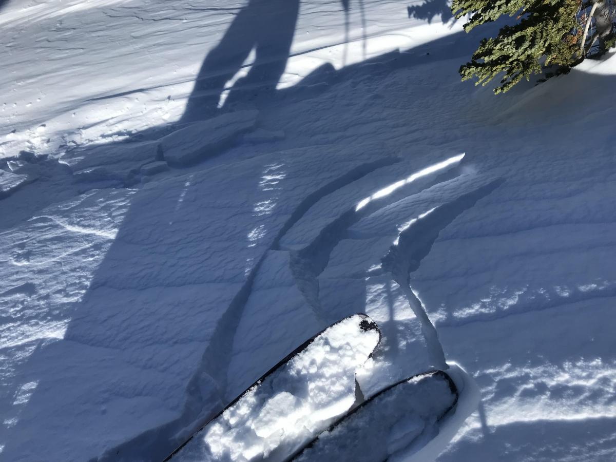
Photo: Reactive wind slabs on Gray Butte. E. Falconer
Mountain Weather:
Low pressure will move southward today over Siskiyou county, bringing one of the colder air masses of the season. The cold front will arrive this morning, ahead of the storm. An upper trough will arrive midday today, bringing cold northwest winds, and some light precipitation through Tuesday. Moderate temperatures will start out this morning, dropping quickly through the day and into the evening. Freezing levels will be at 4,500 feet, then dropping to the base this evening through Tuesday. Northwest winds will be something to watch in the next 24 hours. Winds are expected to ramp up today, easily exceeding extreme (>38 mph) speeds near and above treeline. This will create widespread blowing snow and heinously low wind chill values at high elevations. This storm is expected to provide two to five inches of snow. The next bit of snow is expected from Tuesday to Wednesday.
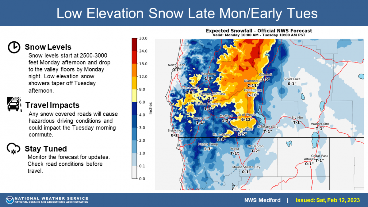
Image: NWS Medford.
Today 7-8 Weather :
Mostly sunny. Chance of snow showers after 4pm. Windy, with gusts as high as 60 mph. Freezing level around 4,500 feet
Today 7-8 Wind Direction:
NW
Today 8-9 Weather:
Mostly sunny. Chance of snow showers after 4pm. Widespread blowing snow. Windy, with gusts as high as 115 mph. Wind chill values as low as -23
Today 8-9 Wind Direction:
NW
Tomorrow 7-8 Weather:
Snow before 10am, then cloudy with a chance of snow showers. Some blowing snow. Wind chill as low as -4. Freezing level will be at the base
Tomorrow 7-8 Wind Direction:
NW
Tomorrow 8-9 Weather:
Chance of snow after 10am. Mostly sunny, with gusts up to 100 mph. Widespread blowing snow. Wind chill values as low as -37
Tomorrow 8-9 Wind Direction:
NW
Tonight 7-8 Weather:
Snow, mainly after 4am. Wind chill as low as -7. Windy, with gusts up to 49 mph. Freezing level will be at the base
Tonight 7-8 Wind Direction:
NW
Tonight 8-9 Weather:
Snow, mainly after 4am. Widespread blowing snow. Wind chill as low as -38. Windy, with gusts up to 115 mph
Tonight 8-9 Wind Direction:
NW
27
20
48
31
101
0
0
33.5
33.5
46.5
39.5
126.3
0
0
Grey Butte Temp Cur:
37.5
Grey Butte Temp Min:
34.5
Grey Butte Temp Max:
43.5
Grey Butte Wind Max:
27.5
Grey Butte Wind Gust Max:
55.2
Castle Lake Temp Cur:
39.5
Castle Lake Temp Max:
47.5
Mount Eddy Temp Min:
32.5
Mount Eddy Temp Avg:
40.5
Mount Eddy Wind Gust Max:
6.87
Mount Eddy Snow Depth:
104
Ash Creek Bowl Temp Cur:
30
Ash Creek Bowl Temp Min:
23
Ash Creek Bowl Temp Max:
45
Ash Creek Bowl Temp Avg:
31
Ash Creek Bowl Snow New:
47.6
Ash Creek Ridge Temp Cur:
32.5
Ash Creek Ridge Temp Min:
27.5
Ash Creek Ridge Temp Max:
46.5
Ash Creek Ridge Temp Avg:
34.5
Ash Creek Ridge Wind Cur:
14.5
Ash Creek Ridge Wind Max:
14.5
Ash Creek Ridge Wind Gust Max:
21.53
Ash Creek Ridge Wind Avg:
WSW
Mt. Shasta City Temp Cur:
31
Mt. Shasta City Temp Min:
29
Mt. Shasta City Temp Max:
56
Mt. Shasta City Temp Avg:
40.5
Mt. Shasta City Wind Cur:
0
Mt. Shasta City Wind Min:
0
Mt. Shasta City Wind Max:
7
Mt. Shasta City Wind Avg:
1.5
Mt. Shasta City Wind Avg:
N
Ash Creek Ridge Wind Min:
1.5
Ash Creek Ridge Wind Avg:
6
Sand Flat Snow Settlement:
1
Ski Bowl Snow Settlement:
1
Mount Eddy Snow Settlement:
1.2
Ash Creek Bowl Snow Settlement:
0
Measured Precipitation Oct:
26.9
Normal Precipitation Oct:
20.95
Percent Precipitation Oct:
128
Measured Precipitation MTD:
1.02
Normal Precipitation MTD:
2.42
Percent Precipitation MTD:
42
Measured Precipitation YTD:
17.77
Normal Precipitation YTD:
8.71
Percent Precipitation YTD:
204
Tomorrow Wind Max 7-9:
20
Tomorrow Wind Min 7-9:
10
Tonight Wind Max 9-11:
45
Tomorrow Wind Max 9-11:
40
Tonight Wind Min 9-11:
35
Tomorrow Wind Min 9-11:
30
Tonight Snow Max 7-9:
2.00
Tomorrow Snow Max 7-9:
2.00
Tonight Snow Min 7-9:
1.00
Tomorrow Snow Min 7-9:
1.00
Today Snow Max 9-11:
0.50
Tonight Snow Max 9-11:
3.00
Tomorrow Snow Max 9-11:
2.00
Today Snow Min 9-11:
0.00
Tonight Snow Min 9-11:
1.00
Tomorrow Snow Min 9-11:
1.00
Weather Station Discussion:
The table below summarizes data reported from all of our weather stations over the last 24 hours.
Seasonal Stats Discussion:
The wet season is October 1 through May 1. The table below summarizes recorded vs. normal precipitation amounts for the City of Mount Shasta.
Overall Danger Rating:
Moderate


