Submitted by sclairmont on Mon, 02/20/2023 - 4:49am
Recent Observations:
Over the past 24 hours, warm and dry weather continued for the Mount Shasta region. Southeast winds strengthened to moderate, gusting to strong. On the upper mountain, winds have been well above strong into the extreme category. Lenticular clouds were observed atop Mount Shasta, Castle lake, and town, suggesting extreme winds aloft.
Yesterday's observations were from the Eddy Mountains, where variable conditions were prevalent near and above treeline. Melt freeze crusts, old wind slab, soft decaying snow, and scoured ice patches could all be found across all aspects. Moderate southeast winds remained consistent throughout the day, however, the current poor surface conditions did not allow for any wind transport. Below treeline, soft snow could be found in shaded and protected areas. By midday, warm temperatures allowed for very sticky snow.
No avalanche activity has been observed or reported in the last few days.
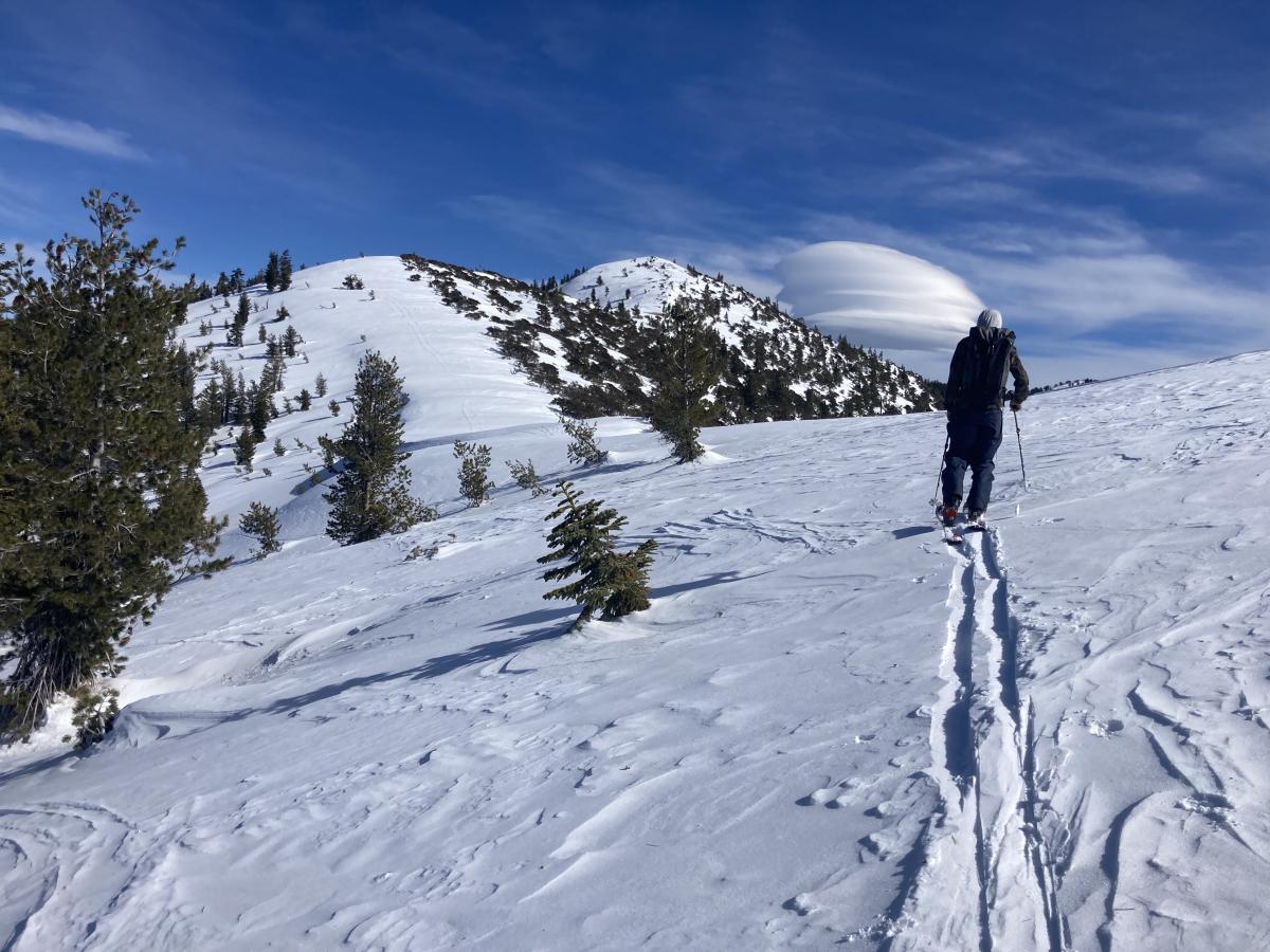
Image: Surface conditions near treeline, with lenticular clouds in the distance. S. Clairmont
Mountain Weather:
This morning, high level clouds are keeping temperatures five to ten degrees above normal. As of 4 am, Gray Butte weather station (8,000 feet) is recording a temperature of 43 degrees. Except for high level clouds, today will be similar to the previous days, warm and dry conditions before transitioning tonight.
A large high pressure centered well offshore will move westward today as high pressure continues for one last day. Northwest flow will continue for the Mount Shasta area. Weather will begin to shift out of a high pressure tonight, with a cold front arriving Tuesday morning. Snow will begin to fall Tuesday, sparking the return of winter weather till at least Thursday. This cold front will also bring strong northerly winds to the mountains. Above treeline, winds are expected to be well into the extreme category (>38 mph) by Tuesday, creating bitterly cold wind chill values.
On another note, this cold front will easily bring cold enough temps for snow in the valleys. This may affect road travel.
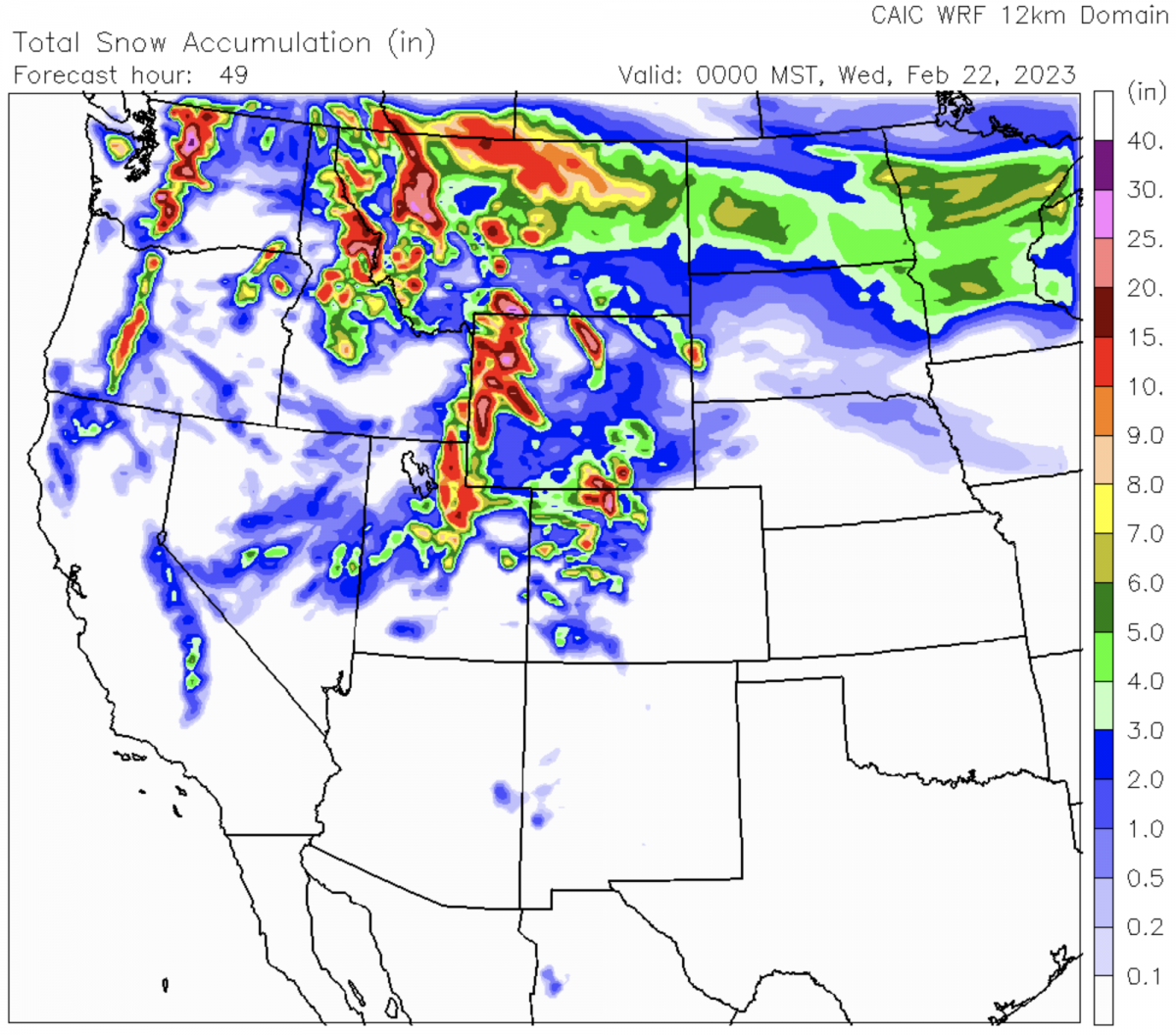
Image: Snow total forecast between today and Wednesday by the CAIC.
Today 7-8 Weather :
Mostly sunny. Gusts as high as 28 mph. Freezing level around 6,600 feet
Today 7-8 Wind Direction:
NW
Today 8-9 Weather:
Mostly sunny. Windy, with gusts up to 90 mph
Today 8-9 Wind Direction:
N
Tomorrow 7-8 Weather:
Chance of snow, mainly after 10 am. Patchy blowing snow. Partly sunny. Gusts as high as 50 mph. Freezing level at the base
Tomorrow 7-8 Wind Direction:
NW
Tomorrow 8-9 Weather:
Chance of snow after 11 am. Widespread blowing snow. Partly sunny. Wind chill values as low as -32. Windy, with gusts as high as 115 mph
Tomorrow 8-9 Wind Direction:
NW
Tonight 7-8 Weather:
Chance of snow after 4 am. Partly cloudy. Blustery, with gusts as high as 41 mph. Freezing level around 6,100 feet
Tonight 7-8 Wind Direction:
NW
Tonight 8-9 Weather:
Chance of snow after 5 am. Widespread blowing snow after 2 am. Partly cloudy. Windy, with gusts as high as 115 mph
Tonight 8-9 Wind Direction:
NW
32
21
48
32
98
0
0
42.5
27.5
47
38
122.5
0
0
Grey Butte Temp Cur:
42.5
Grey Butte Temp Min:
30.5
Grey Butte Temp Max:
42.5
Grey Butte Temp Avg:
37.5
Grey Butte Wind Max:
10.5
Grey Butte Wind Gust Max:
42.93
Castle Lake Temp Cur:
40.5
Castle Lake Temp Max:
48.5
Mount Eddy Temp Avg:
39.5
Mount Eddy Wind Gust Max:
6.79
Mount Eddy Snow Depth:
100.2
Ash Creek Bowl Temp Cur:
42
Ash Creek Bowl Temp Min:
27
Ash Creek Bowl Temp Max:
42
Ash Creek Bowl Temp Avg:
32.5
Ash Creek Bowl Snow New:
0
Ash Creek Ridge Temp Cur:
34.5
Ash Creek Ridge Temp Min:
25
Ash Creek Ridge Temp Max:
39.5
Ash Creek Ridge Temp Avg:
32
Ash Creek Ridge Wind Cur:
14
Ash Creek Ridge Wind Max:
17
Ash Creek Ridge Wind Gust Max:
21.81
Ash Creek Ridge Wind Avg:
SW
Mt. Shasta City Temp Cur:
40
Mt. Shasta City Temp Min:
32
Mt. Shasta City Temp Max:
56
Mt. Shasta City Temp Avg:
45
Mt. Shasta City Wind Cur:
3
Mt. Shasta City Wind Min:
0
Mt. Shasta City Wind Max:
6
Mt. Shasta City Wind Avg:
2.5
Ash Creek Ridge Wind Min:
3.5
Ash Creek Ridge Wind Avg:
9.5
Sand Flat Snow Settlement:
1
Ski Bowl Snow Settlement:
0.6
Mount Eddy Snow Settlement:
0.7
Ash Creek Bowl Snow Settlement:
0
Measured Precipitation Oct:
26.97
Normal Precipitation Oct:
22.74
Percent Precipitation Oct:
119
Measured Precipitation MTD:
1.09
Normal Precipitation MTD:
4.21
Percent Precipitation MTD:
26
Measured Precipitation YTD:
17.84
Normal Precipitation YTD:
10.5
Percent Precipitation YTD:
170
Tomorrow Wind Max 7-9:
30
Tomorrow Wind Min 7-9:
20
Tonight Wind Max 9-11:
55
Tomorrow Wind Max 9-11:
60
Tonight Wind Min 9-11:
45
Tomorrow Wind Min 9-11:
50
Tonight Snow Max 7-9:
0.00
Tomorrow Snow Max 7-9:
4.00
Tonight Snow Min 7-9:
0.00
Tomorrow Snow Min 7-9:
2.00
Today Snow Max 9-11:
0.00
Tonight Snow Max 9-11:
0.00
Tomorrow Snow Max 9-11:
0.00
Today Snow Min 9-11:
0.00
Tonight Snow Min 9-11:
0.00
Tomorrow Snow Min 9-11:
0.00
Weather Station Discussion:
The table below summarizes data reported from all of our weather stations over the last 24 hours.
Seasonal Stats Discussion:
The wet season is October 1 through May 1. The table below summarizes recorded vs. normal precipitation amounts for the City of Mount Shasta.
Overall Danger Rating:
Low


