Submitted by sclairmont on Sun, 02/26/2023 - 5:12am
Recent Observations:
The February 23rd and 24th snow event brought a total of 46 inches at treeline on Mount Shasta, remaining quite cold through the storm period. Yesterday brought sun and warmth, with temperatures rising to 35 F near treeline and 48 F in town. Winds remained moderate out of the east.
Yesterday's observations came from Gray Butte area. Saturation of the snowpack started almost immediately, with new snow turning heavy, and ski touring becoming quite difficult and tiring. Though forecasted temps were around freezing near treeline, actual surface conditions warmed considerably more. This will likely have saturated the surface up to 8,000 feet. This could result in a surface crust this morning with cooling conditions. Below and near treeline, evidence of strong wind transport could be found abundantly. Ridgelines had sastrugi nearly three feet tall, areas scoured down to the old snow, and remarkable wind drifts.
A pit dug at ~7,500 feet with a northwest aspect showed 31 inches of new snow over a thin graupel layer, and melt freeze old snow. The new snow is right side up, well glued to the old snow, and did not show signs of instability. This could be due to the amount of warming and settling that occurred during the day. Tests resulted in a ECTX for the most part, with a slight collapse in the new snow at a marginal density change.
No avalanches have been reported or observed in the last couple of days. That being said, based off the impressive amount of new snow, very high precipitation intensity mid-storm, and the recent wind, avalanches must be considered in decision-making.
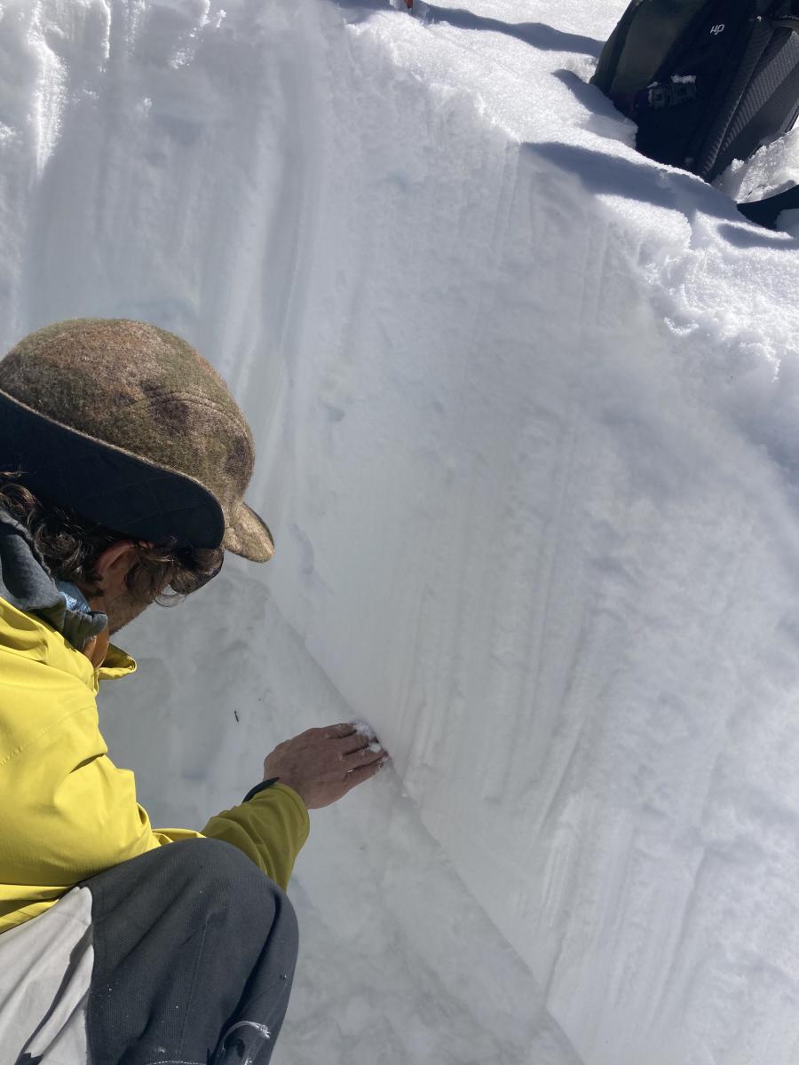
Image: Nick looking at the graupel layer under the new snow. S. Clairmont
Mountain Weather:
The first front of a series of cold systems will arrive this morning. A winter weather advisory is in effect for much of Siskiyou county. Snow levels will initially be around 4,000 feet, and then dropping to 1,700 feet for the next couple of days. Gusty winds will accompany the front. Winds are expected to be strong to extreme above treeline, with wind chill values as low as -30 F above 11,000 feet. Blowing snow is expected today near and above treeline, expect visibility to be poor. Monday will bring another system that has more moisture and colder air. Models suggest this will be another heavy snow event for the Mount Shasta region. After Monday, more systems appear to be tracking for the weekend.
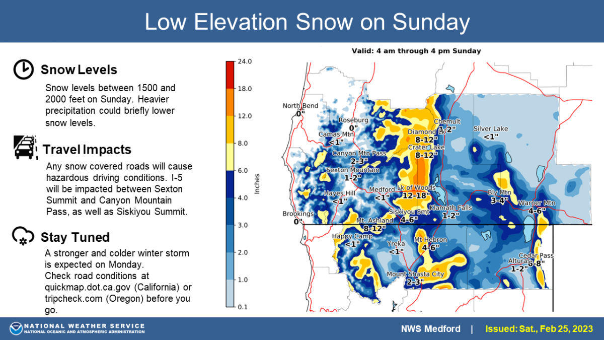
Image: NWS Medford
Today 7-8 Weather :
Snow before 10am, then snow showers until 4pm. Snow could be heavy at times. Windy, with gusts up to 37 mph. Freezing level will be at the base
Today 7-8 Wind Direction:
SW
Today 8-9 Weather:
Snow before 10am, then snow showers. Snow could be heavy at times. Wind chill values as low as -19. Gusts up to 90 mph.
Today 8-9 Wind Direction:
W
Tomorrow 7-8 Weather:
Snow before 10am, then snow showers. Snow could be heavy at times. Widespread blowing snow, mainly before 4pm. Wind chill values as low as -7. Gusts up to 55 mph. Freezing level will be at the base
Tomorrow 7-8 Wind Direction:
S
Tomorrow 8-9 Weather:
Snow, then snow showers after 10am. Snow could be heavy at times. Widespread blowing snow. Wind chill values as low as -34. Windy, with gusts up to 115 mph.
Tomorrow 8-9 Wind Direction:
SW
Tonight 7-8 Weather:
Snow, mainly after 4am. Snow could be heavy at times. Patchy blowing snow after 10pm. Gusts up to 55 mph. Freezing level will be at the base
Tonight 7-8 Wind Direction:
SW
Tonight 8-9 Weather:
Snow, mainly after 4am. Snow could be heavy at times. Widespread blowing snow. Wind chill values as low as -30. Gusts up to 65 mph.
Tonight 8-9 Wind Direction:
SW
22
22
38
29
118
0
0
17.5
17.5
35
26.5
143.5
0
0.26
Grey Butte Temp Cur:
16.5
Grey Butte Temp Min:
16.5
Grey Butte Temp Max:
29.5
Grey Butte Temp Avg:
24.5
Grey Butte Wind Cur:
13.5
Grey Butte Wind Gust Max:
55.2
Castle Lake Temp Min:
24.5
Castle Lake Temp Avg:
31.5
Mount Eddy Temp Cur:
26.5
Mount Eddy Temp Min:
22.5
Mount Eddy Temp Avg:
27.5
Mount Eddy Wind Gust Max:
6.18
Mount Eddy Snow Depth:
126.9
Ash Creek Bowl Temp Cur:
19.5
Ash Creek Bowl Temp Min:
19.5
Ash Creek Bowl Temp Max:
37
Ash Creek Bowl Temp Avg:
26
Ash Creek Bowl Snow New:
0
Ash Creek Ridge Temp Cur:
17
Ash Creek Ridge Temp Min:
14.5
Ash Creek Ridge Temp Max:
31.5
Ash Creek Ridge Temp Avg:
23.5
Ash Creek Ridge Wind Cur:
11.5
Ash Creek Ridge Wind Max:
21
Ash Creek Ridge Wind Gust Max:
28.3
Mt. Shasta City Temp Cur:
32
Mt. Shasta City Temp Min:
18
Mt. Shasta City Temp Max:
48
Mt. Shasta City Temp Avg:
34
Mt. Shasta City Wind Cur:
5
Mt. Shasta City Wind Min:
0
Mt. Shasta City Wind Max:
5
Mt. Shasta City Wind Avg:
2
Mt. Shasta City Wind Avg:
N
Ash Creek Ridge Wind Min:
0
Ash Creek Ridge Wind Avg:
5
Sand Flat Snow Settlement:
9
Ski Bowl Snow Settlement:
3.7
Mount Eddy Snow Settlement:
5.1
Ash Creek Bowl Snow Settlement:
4.1
Measured Precipitation Oct:
28.51
Normal Precipitation Oct:
24.23
Percent Precipitation Oct:
118
Measured Precipitation MTD:
2.63
Normal Precipitation MTD:
5.7
Percent Precipitation MTD:
46
Measured Precipitation YTD:
19.38
Normal Precipitation YTD:
11.99
Percent Precipitation YTD:
162
Tomorrow Wind Max 7-9:
35
Tomorrow Wind Min 7-9:
25
Tonight Wind Max 9-11:
35
Tomorrow Wind Max 9-11:
65
Tonight Wind Min 9-11:
25
Tomorrow Wind Min 9-11:
55
Today Snow Max 7-9:
11.00
Tonight Snow Max 7-9:
7.00
Tomorrow Snow Max 7-9:
15.00
Tonight Snow Min 7-9:
3.00
Tomorrow Snow Min 7-9:
9.00
Today Snow Max 9-11:
12.00
Tonight Snow Max 9-11:
7.00
Tomorrow Snow Max 9-11:
14.00
Today Snow Min 9-11:
8.00
Tonight Snow Min 9-11:
3.00
Tomorrow Snow Min 9-11:
10.00
Weather Station Discussion:
The table below summarizes data reported from all of our weather stations over the last 24 hours.
Seasonal Stats Discussion:
The wet season is October 1 through May 1. The table below summarizes recorded vs. normal precipitation amounts for the City of Mount Shasta.
Overall Danger Rating:
Moderate


