Submitted by efalconer on Tue, 02/28/2023 - 6:00am
Recent Observations:
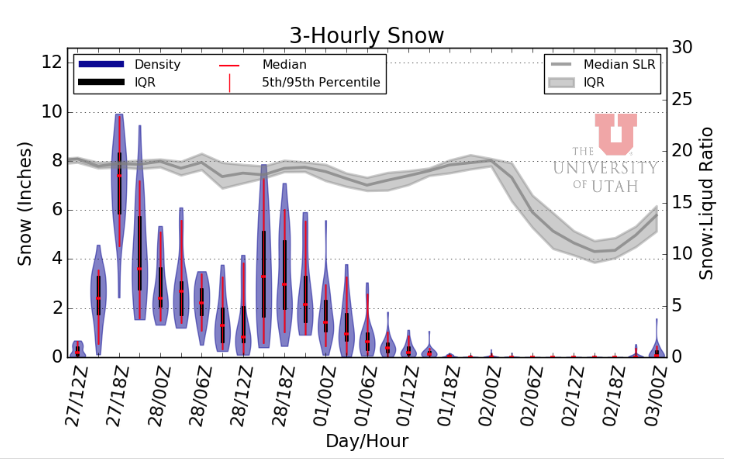
Winter has made a healthy comeback to say the least. With the large amounts of new snow, storm slabs and dry loose snow were encountered near and below treeline on all aspects yesterday in the Eddy mountains. Storm slabs were touchy on steep convex terrain features and broke over a foot deep. Winds blowing from the west and southwest howled all day long, transporting snow onto leeward slopes. Snowfall rates of one inch per hour persisted for the majority of the outing. The snowpack near and below treeline is displaying a well bonded right side up structure with over 55 inches (130 cm) of snow since February 23rd. All this new snow is sitting upon a mixture of melt-freeze crusts and firm old snow.
Mountain Weather:
An upper level low-pressure system remains entrenched over the west coast sending another round of snow, wind, and cold temperatures our way. Near treeline winds have averaged a speed of 14 mph with a max gust of 49 mph. Temperatures have remained in the teens with one inch of new snow reported in the western mountains this morning. Snowfall is expected to pick back up this morning and fall through the majority of the day, winding down by early evening. The mountains could see another 10 inches of new snow by the end of today. Winds will blow at moderate speeds from the southwest and west, shifting northward by this evening. Below-freezing temperatures associated with this storm will impact the region today through Wednesday as the storm moves its way down out of the region. This exodus with shift the weather back to a north and northwest flow through Thursday.
Today 7-8 Weather :
Snow showers mainly before 4 pm. The snow could be heavy at times. Windy, with widespread blowing snow
Today 7-8 Wind Direction:
SW
Today 8-9 Weather:
Snow showers mainly before 4pm. Mostly cloudy, with wind chill values as low as -25
Today 8-9 Wind Direction:
SW
Tomorrow 7-8 Weather:
Mostly sunny, with wind chill values as low as -9 and gust as high as 37 mph
Tomorrow 7-8 Wind Direction:
N
Tomorrow 8-9 Weather:
Mostly sunny and cold, with wind chill values as low as -33. Windy, with gusts as high as 50 mph
Tomorrow 8-9 Wind Direction:
N
Tonight 7-8 Weather:
A 40 percent chance of snow showers, mainly before 10pm. Mostly cloudy, with gusts as high as 28 mph
Tonight 7-8 Wind Direction:
NW
Tonight 8-9 Weather:
A 50 percent chance of snow showers, mainly before 10pm. Mostly cloudy, with wind chill values as low as -31
Tonight 8-9 Wind Direction:
NW
14
14
22
18
126
9
0
9.5
9.5
16
12.5
148.4
10.8
0
Grey Butte Wind Gust Max:
49.07
Castle Lake Temp Cur:
14.5
Castle Lake Temp Min:
14.5
Mount Eddy Temp Min:
12.5
Mount Eddy Temp Max:
21.5
Mount Eddy Temp Avg:
16.5
Mount Eddy Wind Gust Max:
7.02
Mount Eddy Snow Depth:
140.2
Mount Eddy Snow New:
12.8
Ash Creek Bowl Temp Cur:
11
Ash Creek Bowl Temp Min:
11
Ash Creek Bowl Temp Max:
16.5
Ash Creek Bowl Temp Avg:
14
Ash Creek Bowl Snow New:
8.9
Ash Creek Ridge Temp Cur:
7.5
Ash Creek Ridge Temp Min:
7
Ash Creek Ridge Temp Max:
13
Ash Creek Ridge Temp Avg:
10.5
Ash Creek Ridge Wind Cur:
0
Ash Creek Ridge Wind Max:
0
Ash Creek Ridge Wind Gust Max:
0
Mt. Shasta City Temp Cur:
26
Mt. Shasta City Temp Min:
26
Mt. Shasta City Temp Max:
32
Mt. Shasta City Temp Avg:
28.5
Mt. Shasta City Wind Cur:
3
Mt. Shasta City Wind Min:
0
Mt. Shasta City Wind Max:
4
Mt. Shasta City Wind Avg:
2
Mt. Shasta City Wind Avg:
N
Ash Creek Ridge Wind Min:
0
Ash Creek Ridge Wind Avg:
0
Sand Flat Snow Settlement:
0
Ski Bowl Snow Settlement:
0
Mount Eddy Snow Settlement:
0
Ash Creek Bowl Snow Settlement:
0
Measured Precipitation Oct:
28.59
Normal Precipitation Oct:
24.47
Percent Precipitation Oct:
117
Measured Precipitation MTD:
2.71
Normal Precipitation MTD:
5.94
Percent Precipitation MTD:
46
Measured Precipitation YTD:
19.46
Normal Precipitation YTD:
12.23
Percent Precipitation YTD:
159
Tomorrow Wind Max 7-9:
25
Tomorrow Wind Min 7-9:
10
Tonight Wind Max 9-11:
25
Tomorrow Wind Max 9-11:
35
Tonight Wind Min 9-11:
15
Tomorrow Wind Min 9-11:
25
Tonight Snow Max 7-9:
2.00
Tomorrow Snow Max 7-9:
0.00
Tonight Snow Min 7-9:
1.00
Tomorrow Snow Min 7-9:
0.00
Today Snow Max 9-11:
9.00
Tonight Snow Max 9-11:
2.00
Tomorrow Snow Max 9-11:
0.00
Today Snow Min 9-11:
5.00
Tonight Snow Min 9-11:
1.00
Tomorrow Snow Min 9-11:
0.00
Weather Station Discussion:
The table below summarizes data reported from all of our weather stations over the last 24 hours.
Seasonal Stats Discussion:
The wet season is October 1 through May 1. The table below summarizes recorded vs. normal precipitation amounts for the City of Mount Shasta.
Overall Danger Rating:
High


