Submitted by sclairmont on Sun, 02/05/2023 - 5:15am
Recent Observations:
Over the past 24 hours, a new storm has brought snow and wind to Siskiyou County. Southwest wind remained light to moderate through the day, gusting to strong later in the evening. Observations from yesterday came from the Old Ski Bowl and Gray Butte area, where cold temperatures and poor visibility persisted through the day. Freezing levels were encountered around 5,000 feet. Below treeline, slightly better than dust on crust conditions combined with large amounts of tree debris made skiing and riding less than ideal. 2–3 inches of low density snow from February 3rd was found above 6,500 feet. Near and above treeline, there appeared to be a little more snow (3-5 inches at 9,000 feet) with some wind effect at ridge tops and exposed southerly slopes. The new snow old snow crust was easily felt under the new snow. Visibility was nearly nonexistent above treeline due to a heavy cloud line around 8,000 feet. No signs of snowpack instability were observed. However, the new snow old snow interface (crust) could present itself as a widespread sliding surface if more weight is added.
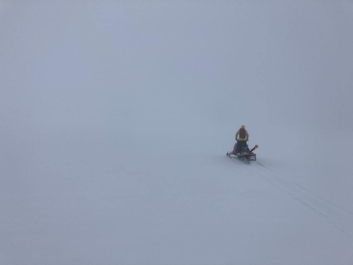
Photo: Visibility in Old Ski Bowl (above treeline). S. Clairmont
Mountain Weather:
The axis of a surface low off the west coast has brought southwest flow to the Mount Shasta region through the night. This storm will persist with snow and southerly wind through today into the evening. Peak precipitation intensities will be until 10am this morning. Precipitation will lighten through the day into tonight and tomorrow. There is a winter weather advisory issued until 10am this morning. A cold front accompanying this storm will likely lower freezing levels today to around 3,600 feet, further lowering to the base tonight. Though light in town, winds will increase drastically near and above treeline, with gusts up to 90 mph at 9,000 feet. Consistent strong to extreme winds should be expected at the upper elevations of Mount Shasta. High pressure will likely set in after Monday, potentially lasting until the weekend.
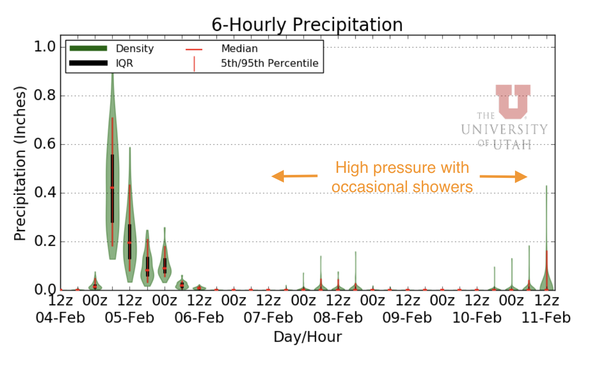
Image: University of Utah's 6-hour precipitation forecast for Mount Shasta.
Today 7-8 Weather :
Snow, mainly below 4pm. Gusts up to 28 mph. Snow level near 3,600 feet
Today 7-8 Wind Direction:
SW
Today 8-9 Weather:
Snow, mainly before 4pm. Snow could be heavy at times. Wind chill values as low as -13. Windy, with gusts up to 55 mph
Today 8-9 Wind Direction:
W
Tomorrow 7-8 Weather:
Mostly sunny. Windy, with gusts up to 34 mph. Snow level will be at the base
Tomorrow 7-8 Wind Direction:
N
Tomorrow 8-9 Weather:
Mostly sunny. Windy, with gusts up to 115 mph. Wind chill values as low as -19
Tomorrow 8-9 Wind Direction:
N
Tonight 7-8 Weather:
A chance of snow showers before 10pm. Mostly cloudy with a low around 19. Windy, with gusts up to 41 mph. Snow level will be at the base
Tonight 7-8 Wind Direction:
NW
Tonight 8-9 Weather:
Chance of snow showers before 10pm. Mostly cloudy, with gusts up to 95 mph. Wind chill values as low as -21
Tonight 8-9 Wind Direction:
NW
27
27
31
29
106
5
0
21
21
27.5
25
133
4.8
0.07
Grey Butte Temp Cur:
21.5
Grey Butte Temp Min:
21.5
Grey Butte Wind Cur:
14.5
Grey Butte Wind Gust Max:
49.07
Mount Eddy Wind Gust Max:
7.61
Mount Eddy Snow Depth:
108.7
Ash Creek Bowl Temp Cur:
24
Ash Creek Bowl Temp Min:
24
Ash Creek Bowl Temp Max:
27.5
Ash Creek Bowl Temp Avg:
26
Ash Creek Bowl Snow New:
5
Ash Creek Ridge Temp Cur:
20
Ash Creek Ridge Temp Min:
20
Ash Creek Ridge Temp Max:
25
Ash Creek Ridge Temp Avg:
23
Ash Creek Ridge Wind Cur:
0
Ash Creek Ridge Wind Max:
0
Ash Creek Ridge Wind Gust Max:
0
Mt. Shasta City Temp Cur:
36
Mt. Shasta City Temp Min:
34
Mt. Shasta City Temp Max:
43
Mt. Shasta City Temp Avg:
38.5
Mt. Shasta City Wind Cur:
3
Mt. Shasta City Wind Min:
0
Mt. Shasta City Wind Max:
6
Mt. Shasta City Wind Avg:
2.5
Mt. Shasta City Wind Avg:
N
Grey Butte Wind Avg:
11.5
Ash Creek Ridge Wind Min:
0
Ash Creek Ridge Wind Avg:
0
Sand Flat Snow Settlement:
0
Ski Bowl Snow Settlement:
0
Mount Eddy Snow Settlement:
0
Ash Creek Bowl Snow Settlement:
0
Measured Precipitation Oct:
26.76
Normal Precipitation Oct:
19.3
Percent Precipitation Oct:
139
Measured Precipitation MTD:
0.88
Normal Precipitation MTD:
0.77
Percent Precipitation MTD:
114
Measured Precipitation YTD:
17.63
Normal Precipitation YTD:
7.06
Percent Precipitation YTD:
250
Tomorrow Wind Max 7-9:
20
Tomorrow Wind Min 7-9:
10
Tonight Wind Max 9-11:
45
Tomorrow Wind Max 9-11:
55
Tonight Wind Min 9-11:
35
Tomorrow Wind Min 9-11:
45
Tonight Snow Max 7-9:
1.00
Tomorrow Snow Max 7-9:
0.00
Tonight Snow Min 7-9:
0.00
Tomorrow Snow Min 7-9:
0.00
Today Snow Max 9-11:
8.00
Tonight Snow Max 9-11:
2.00
Tomorrow Snow Max 9-11:
0.00
Today Snow Min 9-11:
4.00
Tonight Snow Min 9-11:
1.00
Tomorrow Snow Min 9-11:
0.00
Weather Station Discussion:
The table below summarizes data reported from all of our weather stations over the last 24 hours.
Seasonal Stats Discussion:
The wet season is October 1 through May 1. The table below summarizes recorded vs. normal precipitation amounts for the City of Mount Shasta.
Overall Danger Rating:
Considerable


