Submitted by nmeyers on Sat, 03/11/2023 - 5:50am
Recent Observations:
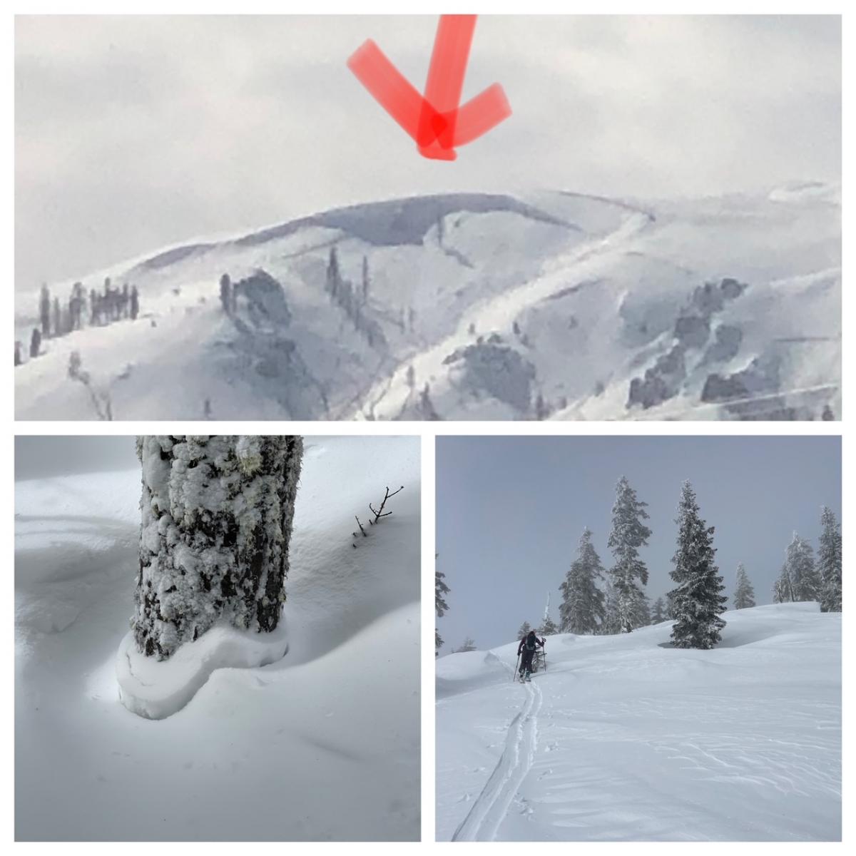
The atmospheric river, round one, came and went. Yesterday morning, we were surprised at how fast things cleared up when we woke to blue sky with no lingering showers, clouds or wind to speak of. The clear sky gradually became partly cloudy for the afternoon. The recent one to two feet of heavy snow as settled rapidly, about six inches. The effects of the sun are instant this time of year and the difference between cloud cover and sun shinning is drastic: hot, cold, hot, cold. We found one recent avalanche on the west face of Gray Butte, but it was badly wind eroded and difficult to tell when it happened. Another observer took a photo of a large natural avalanche outside the forecast area, but nearby, just south of Susanville (photo below).
Overall, red flags of avalanche danger have largely subsided, and the snowpack settled very fast. A weak layer of graupel has been observed 15–20 inches below the snow surface, but pit tests could not produce planar, propagating failures. Wind over the ridges was light out of the west. Previous wind loading was evident. Large, hollow wind slabs up to five feet deep were observed, but stubborn/unreactive to skier weight on test slopes. Wind has blow predominantly out of the W/NW averaging 16 mi/hr with gusts to 61 mi/hr. Temps reached a high of 26 deg F at treeline.
Mountain Weather:
Low pressure resides offshore of British Columbia and this will be the primary driver behind the wheel for the southwest storm track aimed directly at the West Coast. Widespread chances for light to moderate precipitation exists through Sunday. Snow levels will begin around 3,000 feet as snow begins this afternoon and evening, rising to 5,000 feet by late Sunday morning. By Sunday evening, the next atmospheric river event will arrive. As with the previous AR event, we look to remain on the northern periphery of the feature, with the bulk of the moisture aimed to our south. None-the-less, precipitation chances and intensity will increase substantially with the arrival of the AR late Sunday night into Monday. With southwest flow and a subtropical origin of the system, snow levels will remain at or above 5,000 feet until the cold front passes Monday evening. Overall, expect moderate to heavy precipitation with breezy and gusty winds through the day Monday, followed by post frontal showers and slightly lower snow levels through Tuesday and Tuesday night. Calm and dry weather is expected Wednesday and Thursday next week, followed by another wet system late in the week.
Today 7-8 Weather :
A slight chance of snow showers before 10am, then snow likely after 10am. Increasing clouds. Chance of precipitation is 70%.
Snow level: 3,000 feet
Today 7-8 Wind Direction:
S
Today 8-9 Weather:
A slight chance of snow showers before 10am, then snow, mainly after 10am. Windy. Chance of precipitation is 80%.
Today 8-9 Wind Direction:
SW
Tomorrow 7-8 Weather:
Snow. Chance of precipitation is 90%. Snow level: 4,800 feet
Tomorrow 7-8 Wind Direction:
S
Tomorrow 8-9 Weather:
Snow. The snow could be heavy at times. Windy. Chance of precipitation is 100%.
Tomorrow 8-9 Wind Direction:
SW
Tonight 7-8 Weather:
Snow. Chance of precipitation is 90%. Snow level: 3,900 feet
Tonight 7-8 Wind Direction:
S
Tonight 8-9 Weather:
Snow. The snow could be heavy at times. Temperature rising to around 19 by 3am. Windy. Chance of precipitation is 90%.
Tonight 8-9 Wind Direction:
SW
19
14
33
22
148
0
0
11.5
11
26
18
188.3
0
0
Grey Butte Temp Cur:
15.5
Grey Butte Temp Min:
12.5
Grey Butte Wind Gust Max:
61.34
Castle Lake Temp Cur:
-39.5
Castle Lake Temp Min:
-40
Mount Eddy Temp Cur:
16.5
Mount Eddy Wind Gust Max:
6.64
Mount Eddy Snow Depth:
153.3
Ash Creek Bowl Temp Cur:
18.5
Ash Creek Bowl Temp Min:
14.5
Ash Creek Bowl Temp Max:
24.5
Ash Creek Bowl Temp Avg:
20
Ash Creek Bowl Snow New:
0
Ash Creek Ridge Temp Cur:
14.5
Ash Creek Ridge Temp Min:
11.5
Ash Creek Ridge Temp Max:
25
Ash Creek Ridge Temp Avg:
16.5
Ash Creek Ridge Wind Cur:
0
Ash Creek Ridge Wind Max:
58
Ash Creek Ridge Wind Gust Max:
108.79
Mt. Shasta City Temp Cur:
23
Mt. Shasta City Temp Min:
23
Mt. Shasta City Temp Max:
41
Mt. Shasta City Temp Avg:
32
Mt. Shasta City Wind Cur:
0
Mt. Shasta City Wind Min:
0
Mt. Shasta City Wind Max:
5
Mt. Shasta City Wind Avg:
1.5
Mt. Shasta City Wind Avg:
N
Grey Butte Wind Avg:
17.5
Ash Creek Ridge Wind Min:
0
Ash Creek Ridge Wind Avg:
5.5
Sand Flat Snow Settlement:
5
Ski Bowl Snow Settlement:
2.3
Mount Eddy Snow Settlement:
6.4
Ash Creek Bowl Snow Settlement:
17.1
Measured Precipitation Oct:
33.69
Normal Precipitation Oct:
27.06
Percent Precipitation Oct:
125
Measured Precipitation MTD:
3.98
Normal Precipitation MTD:
2.12
Percent Precipitation MTD:
188
Measured Precipitation YTD:
24.56
Normal Precipitation YTD:
14.82
Percent Precipitation YTD:
166
Tomorrow Wind Max 7-9:
20
Tomorrow Wind Min 7-9:
10
Tonight Wind Max 9-11:
40
Tomorrow Wind Max 9-11:
45
Tonight Wind Min 9-11:
30
Tomorrow Wind Min 9-11:
35
Tonight Snow Max 7-9:
5.00
Tomorrow Snow Max 7-9:
7.00
Tonight Snow Min 7-9:
3.00
Tomorrow Snow Min 7-9:
3.00
Today Snow Max 9-11:
3.00
Tonight Snow Max 9-11:
8.00
Tomorrow Snow Max 9-11:
10.00
Today Snow Min 9-11:
1.00
Tonight Snow Min 9-11:
4.00
Tomorrow Snow Min 9-11:
6.00
Weather Station Discussion:
The table below summarizes data reported from all of our weather stations over the last 24 hours.
Seasonal Stats Discussion:
The wet season is October 1 through May 1. The table below summarizes recorded vs. normal precipitation amounts for the City of Mount Shasta.
Overall Danger Rating:
Moderate


