Submitted by efalconer on Tue, 04/11/2023 - 5:28am
Recent Observations:
As of 3 am this morning mountain temperatures are 15 degrees colder than yesterday, with valley temperatures in the upper thirties. Winds have predominantly blown from a south and southwest direction at moderate speeds with strong gusts. Observations from Castle Lake yesterday found wet-loose avalanche activity inevitable on steep north and east aspect near and above treeline. Small amounts of moving snow off test slopes would gouge deeper and encapsulate more snow as it moved downhill. A sizable D 1.5 slide was intentionally triggered with a ski cut and was big enough to bury, seriously injure, or kill someone if caught. Southerly slopes displayed more resistance to sliding than northerly slopes. In part because southerly slope had less dry snow to moisten and destabilize compared to northerly slopes. SUV sized cornices overhanging north and east ridgelines displayed settlement cracks multiple feet behind their edge. Fresh cornice debris was observed below ridgelines with the audible sound of water dripping off of cornices. Above freezing temperatures were experienced, with a high of 45 F.
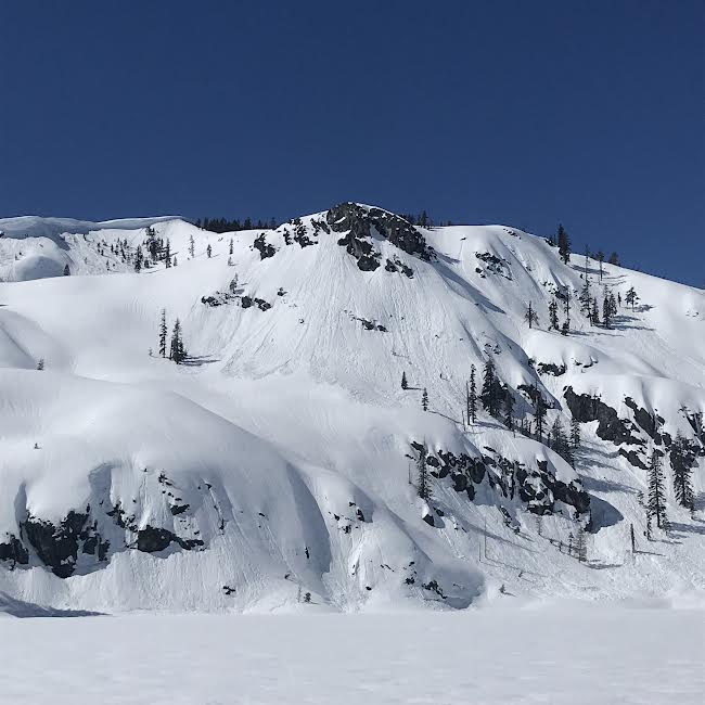
Wet-loose activity off Middle Peak at Castle Lake. Photo E.Falconer
Mountain Weather:
A cold front is moving overland to our north brining shower activity to the western and northern Cascades. Our region may receive some swiping glances of shower activity during the first half of the day at higher elevations. Mount Shasta remains on the lower peripheral of this trough and will not experience as inclement of weather as areas near the Oregon border. Cold temperatures associated with this front have re-entered the region and will linger though today and Wednesday. Another front approaching the coast will make landfall tonight with shower activity remaining north of the region. Winds will blow from a west and northwest direction at calm to light speeds. Temperatures will hover around freezing levels with a progressively clearing sky as the day builds.
Today 7-8 Weather :
Showers likely and possibly a thunderstorm before 11am. Freezing level 6,500 feet
Today 7-8 Wind Direction:
W
Today 8-9 Weather:
Mostly sunny with snow showers likely before 11am. Some thunder is also possible. Wind chill values as low as -12. New snow accumulation of less than a half inch possible
Today 8-9 Wind Direction:
SW
Tomorrow 7-8 Weather:
Sunny. 4,300 feet
Tomorrow 7-8 Wind Direction:
NM
Tomorrow 8-9 Weather:
Sunny, with wind chill values as low as -18
Tomorrow 8-9 Wind Direction:
W
Tonight 7-8 Weather:
Mostly clear. Freezing level 6,900 feet
Tonight 7-8 Wind Direction:
NW
Tonight 8-9 Weather:
Mostly clear. Windy, with wind chill values as low as -20
Tonight 8-9 Wind Direction:
SW
26
2
29
16
146
0
0
41
41
42
41.5
198
0
0
Grey Butte Temp Cur:
31.5
Grey Butte Temp Min:
31.5
Grey Butte Wind Gust Max:
49.07
Castle Lake Snow Depth:
178.1
Mount Eddy Temp Min:
36.5
Mount Eddy Temp Max:
51.5
Mount Eddy Wind Gust Max:
6.4
Mount Eddy Snow Depth:
152.4
Ash Creek Bowl Temp Cur:
36
Ash Creek Bowl Temp Min:
36
Ash Creek Bowl Temp Max:
48
Ash Creek Bowl Temp Avg:
42.5
Ash Creek Bowl Snow New:
0
Ash Creek Ridge Temp Cur:
33
Ash Creek Ridge Temp Min:
32.5
Ash Creek Ridge Temp Max:
41
Ash Creek Ridge Temp Avg:
38
Ash Creek Ridge Wind Cur:
23.5
Ash Creek Ridge Wind Max:
33.5
Ash Creek Ridge Wind Gust Max:
54.62
Ash Creek Ridge Wind Avg:
E
Mt. Shasta City Temp Cur:
44
Mt. Shasta City Temp Min:
35
Mt. Shasta City Temp Max:
68
Mt. Shasta City Temp Avg:
54.5
Mt. Shasta City Wind Cur:
0
Mt. Shasta City Wind Min:
0
Mt. Shasta City Wind Max:
5
Mt. Shasta City Wind Avg:
2
Mt. Shasta City Wind Avg:
N
Grey Butte Wind Avg:
13.5
Ash Creek Ridge Wind Min:
9.5
Ash Creek Ridge Wind Avg:
18
Sand Flat Snow Settlement:
1
Ski Bowl Snow Settlement:
0.3
Castle Lake Snow Settlement:
3.5
Mount Eddy Snow Settlement:
5.2
Ash Creek Bowl Snow Settlement:
0.8
Measured Precipitation Oct:
40.9
Normal Precipitation Oct:
31.71
Percent Precipitation Oct:
129
Measured Precipitation MTD:
1.18
Normal Precipitation MTD:
1.17
Percent Precipitation MTD:
101
Measured Precipitation YTD:
31.77
Normal Precipitation YTD:
19.47
Percent Precipitation YTD:
163
Tomorrow Wind Max 7-9:
20
Tomorrow Wind Min 7-9:
10
Tonight Wind Max 9-11:
40
Tomorrow Wind Max 9-11:
25
Tonight Wind Min 9-11:
30
Tomorrow Wind Min 9-11:
15
Tonight Snow Max 7-9:
0.00
Tomorrow Snow Max 7-9:
0.00
Tonight Snow Min 7-9:
0.00
Tomorrow Snow Min 7-9:
0.00
Today Snow Max 9-11:
0.00
Tonight Snow Max 9-11:
0.00
Tomorrow Snow Max 9-11:
0.00
Today Snow Min 9-11:
0.00
Tonight Snow Min 9-11:
0.00
Tomorrow Snow Min 9-11:
0.00
Weather Station Discussion:
The table below summarizes data reported from all of our weather stations over the last 24 hours.
Seasonal Stats Discussion:
The wet season is October 1 through May 1. The table below summarizes recorded vs. normal precipitation amounts for the City of Mount Shasta.
Overall Danger Rating:
Moderate


