

Submitted by nmeyers on Sat, 04/01/2023 - 5:12am
Recent Observations:
- Yesterday hosted obscured sky with gradually increasing, westerly wind over higher terrain. Temperatures ranged from 21° to 33°. Wind has blow predominantly out of the west, averaging 13 mi/hr with gusts to 42 mi/hr
- Our day brought us to the south end of the forecast area, in the Castle Crags, Whalan Summit, Mumbo Basin area with a snow machine approach via Castle Creek road (FS25). Precipitation was attempted, but no accumulation was observed. Snow level lingered near 4,000 feet
- Snow survey was conducted at the Whalan and Mumbo sites, with average snow depths of 145 and 129 inches respectively.
- We continue to find evidence of a west side weak layer in the snowpack that has resulted in several large avalanches. Yesterday, we found another widely propagating natural avalanche above Mumbo Lake. All of these avalanches occurred earlier in the week, likely on Wednesday. A weak layer of graupel on crust has been buried by two feet of storm snow. Upon stability tests yesterday near the Mumbo avalanche, this layer was stubborn to trigger, but still showed signs of excellent propagation and sheer quality. It would be difficult to trigger an avalanche on this layer, but if you did, a meaty slab is certain
- A widespread, breakable crust dominates snow surfaces in most areas. Only shady, cold, protected and north facing slopes will hold preserved powder
Mountain Weather:
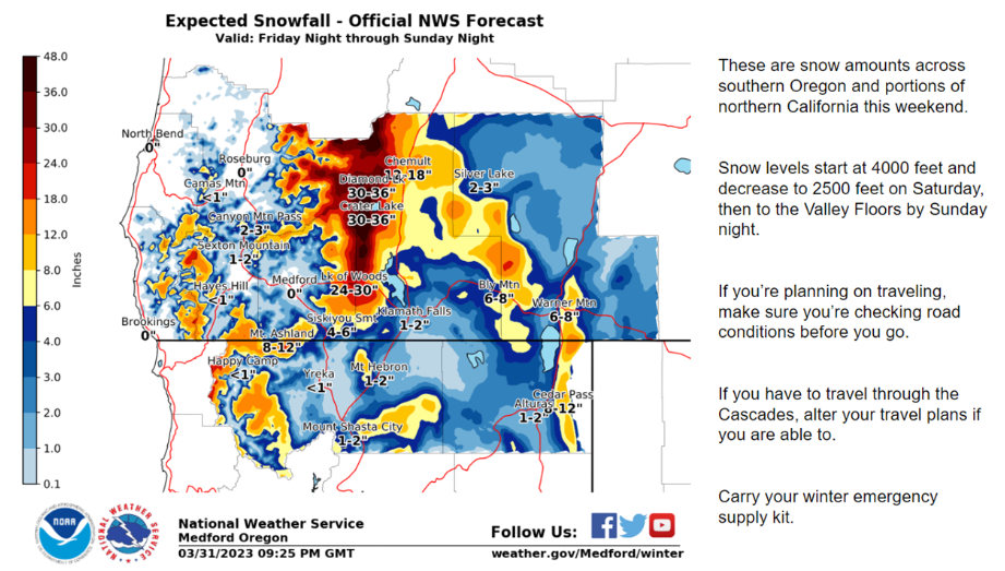
More of the same old! Below normal temperatures are going to persist, and it's going to get even colder the second half of this weekend and into early next week. A northwest flow pattern aloft continues to bring wintry weather into the Pacific Northwest from the Gulf of Alaska. Today, a front will move inland, bringing widespread rain and mountain snow. Snow levels are around 3,500 to 4,000 feet. Areas to the north of Mount Shasta, particularly up around Crater Lake, could receive 2 to 4 feet of fresh snow. For us down here, 3 to 5 inches is forecast for Bunny Flat (6,950 feet). Very strong winds out of the west/southwest will blow above treeline.
Today 7-8 Weather :
Snow before 11am, then snow showers after 11am. The snow could be heavy at times. Breezy. Snow level near 4,100 feetToday 7-8 Wind Direction:
SWToday 8-9 Weather:
Snow before 11am, then snow showers after 11am. The show could be heavy at times. WindyToday 8-9 Wind Direction:
WTomorrow 7-8 Weather:
Snow showers, mainly after 11am. Snow level near 3,900 feetTomorrow 7-8 Wind Direction:
SWTomorrow 8-9 Weather:
Snow showers, mainly after 11am. WindyTomorrow 8-9 Wind Direction:
WTonight 7-8 Weather:
A 50 percent chance of snow showers. Mostly cloudy. Breezy. Snow level near 3,500 feetTonight 7-8 Wind Direction:
WTonight 8-9 Weather:
A 50 percent chance of snow showers. Mostly cloudy. WindyTonight 8-9 Wind Direction:
WToday 7-8 Temp:
29Today 8-9 Temp:
18Tomorrow 7-8 Temp:
26Tomorrow 8-9 Temp:
11Tonight 7-8 Temp:
18Tonight 8-9 Temp:
526
2
29
16
146
0
0
22
19
24.5
22
204.3
0
0
Grey Butte Temp Cur:
21.5Grey Butte Temp Min:
18.5Grey Butte Temp Max:
23.5Grey Butte Temp Avg:
21Grey Butte Wind Cur:
12.5Grey Butte Wind Max:
17.5Grey Butte Wind Gust Max:
42.93Grey Butte Wind Avg:
WCastle Lake Snow Depth:
180.2Castle Lake Snow New:
0Mount Eddy Temp Cur:
25.5Mount Eddy Temp Min:
20Mount Eddy Temp Max:
33Mount Eddy Temp Avg:
26.5Mount Eddy Wind Cur:
1.5Mount Eddy Wind Max:
3.5Mount Eddy Wind Gust Max:
6.43Mount Eddy Wind Avg:
SEMount Eddy Snow Depth:
167.8Mount Eddy Snow New:
0Ash Creek Bowl Temp Cur:
24Ash Creek Bowl Temp Min:
20Ash Creek Bowl Temp Max:
24.5Ash Creek Bowl Temp Avg:
23Ash Creek Bowl Snow New:
0Ash Creek Ridge Temp Cur:
20.5Ash Creek Ridge Temp Min:
16.5Ash Creek Ridge Temp Max:
23Ash Creek Ridge Temp Avg:
20Ash Creek Ridge Wind Cur:
0Ash Creek Ridge Wind Max:
0Ash Creek Ridge Wind Gust Max:
0Mt. Shasta City Temp Cur:
36Mt. Shasta City Temp Min:
33Mt. Shasta City Temp Max:
41Mt. Shasta City Temp Avg:
37Mt. Shasta City Wind Cur:
6Mt. Shasta City Wind Min:
0Mt. Shasta City Wind Max:
6Mt. Shasta City Wind Avg:
3Sand Flat Comments:
Not respondingSki Bowl Comments:
Water content downGrey Butte Wind Min:
7.5Grey Butte Wind Avg:
14Caslte Lake Comments:
Temp sensor downMount Eddy Wind Min:
1Mount Eddy Wind Avg:
2Ash Creek Ridge Wind Min:
0Ash Creek Ridge Wind Avg:
0Sand Flat Snow Settlement:
1Ski Bowl Snow Settlement:
0.8Castle Lake Snow Settlement:
1.5Mount Eddy Snow Settlement:
3Ash Creek Bowl Snow Settlement:
16.4Measured Precipitation Oct:
39.72Normal Precipitation Oct:
30.54Percent Precipitation Oct:
130Measured Precipitation MTD:
10.01Normal Precipitation MTD:
5.6Percent Precipitation MTD:
179Measured Precipitation YTD:
30.59Normal Precipitation YTD:
18.3Percent Precipitation YTD:
167Today SWE:
0.26Tonight SWE:
0.01Tomorrow SWE:
0.07Today Wind Max 7-9:
23Tonight Wind Max 7-9:
17Tomorrow Wind Max 7-9:
17Today Wind Min 7-9:
13Tonight Wind Min 7-9:
7Tomorrow Wind Min 7-9:
7Today Wind Max 9-11:
53Tonight Wind Max 9-11:
45Tomorrow Wind Max 9-11:
39Today Wind Min 9-11:
43Tonight Wind Min 9-11:
35Tomorrow Wind Min 9-11:
29Today Snow Max 7-9:
5.00Tonight Snow Max 7-9:
0.50Tomorrow Snow Max 7-9:
3.00Today Snow Min 7-9:
3.00Tonight Snow Min 7-9:
0.00Tomorrow Snow Min 7-9:
1.00Today Snow Max 9-11:
5.00Tonight Snow Max 9-11:
0.50Tomorrow Snow Max 9-11:
3.00Today Snow Min 9-11:
3.00Tonight Snow Min 9-11:
0.00Tomorrow Snow Min 9-11:
1.00Ash Creek Bowl HS:
158.3Weather Station Discussion:
The table below summarizes data reported from all of our weather stations over the last 24 hours.Seasonal Stats Discussion:
The wet season is October 1 through May 1. The table below summarizes recorded vs. normal precipitation amounts for the City of Mount Shasta. Overall Danger Rating:
ModerateCurrent Time:
2:00 AM
